

iiwhistlerii
-
Posts
404 -
Joined
-
Last visited
Content Type
Profiles
Forums
Events
Gallery
Store
Posts posted by iiwhistlerii
-
-
I used to fish it regularly with my 2001 tracker 175 with a 60hp. That being said it was a slow rough go getting under the bridge and past the plant unless it was low water levels first thing in the morning. With todays water levels you are going to be puckering up and turning back more often than not. You'd probably be fine under normal winter water levels but with the great lakes being where they are who knows when we will see those again. Also with a 60 you'll definitely have a slow go with anything more than 2 guys under any conditions. If your goal is to fish above the dams safely I'd reccomend spending the 6k.
-
 1
1
-
-
40 minutes ago, Fat Trout said:
If I understand the chinook diver setup described on this thread (and others) its a different animal. But for slide diver vs regular its all about lead length and each will have its advantage. Where there is no contest is in not having a sufficient crew (especially solo). Running a regular diver solo with a long lead is problematic. Running solo a lot slide divers make divers a reality for me. I get bit plenty on slide divers. Originally when in a multi person boat before I realized lead length mattered I learned the difference between a 6 ft lead (and no or minimal bites) and a 12' lead. With a slide diver I can go out to 25+ which I prefer.
Back to the Chinook diver which I understand to be a really short lead behind the boat, I have to believe that is water clarity dependent. I fish east and clear water is the norm or at least frequent. However I like the idea of a choked up short presentation when I know I have color to work with.
Clear water, dirty water, I've had them be smoking hot in both situations but it seems they've been best when I have schools of baitfish around. "The butcher" shower me the chinook diver tactic a few years back after using them on the yankee. They've been smoking fish for me ever since. In musky fishing we call it "the cone of disturbance theory" part of the theory is keeping baits just outside the prop wash disturbance so they keep getting knocked to the side by the wash. We've proven this to be a trigger over and over again even to the point where the rod on the kicker side will take 4 out of 5 hits at times. The other part of the theory and it really holds true in shortline musky fishing is that the prop wash is actually what's attracting these fish. These fish are used to boats and when we blast through schools of baitfish we mix up water and leave stunned and injured baitfish in our wake. These fish have learned to key in on and actually feed in the wash and pick off the easy prey. It's amazing how hot those wash rods can be even when you have the exact same baits the same distance back on a board and itll go untouched or have the same spoon on a rigger down 4 feet with a 50 ft lead and never get a sniff but the chinook back 7 is getting chowed non stop. Theres something to being right in or just outside that prop wash. For those who havent tried it, try it.
-
Exactly so make sure to price it out both ways. My 2005 chrestliner tournament 192 was cheaper directly through boat US. My 2018 Skeeter mx1825 is cheaper through Geico. Typical insurance company BS.
-
Geico boat insurance includes boat us on water and roadside assistance. Price it out both ways because for me it was cheaper to go through geico.
-
3 minutes ago, LongLine said:
gyre going back to normal (counterclockwise)
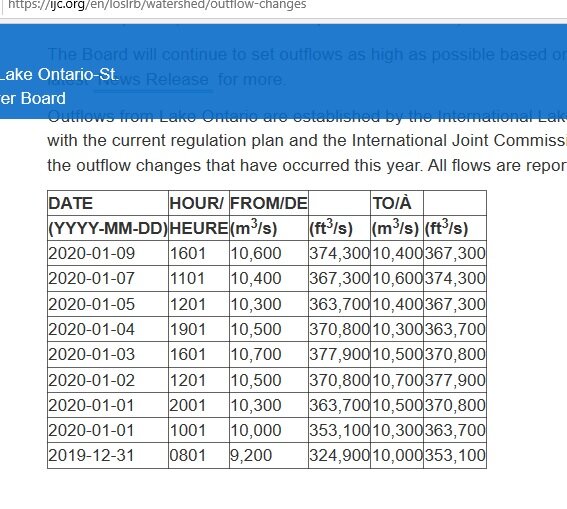
outflow:

Ogdensburg
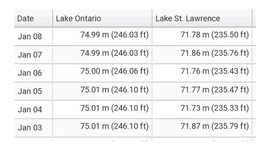
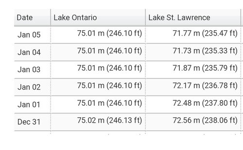
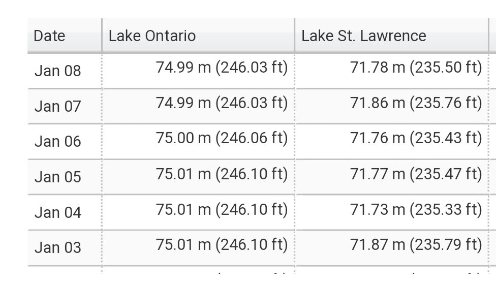
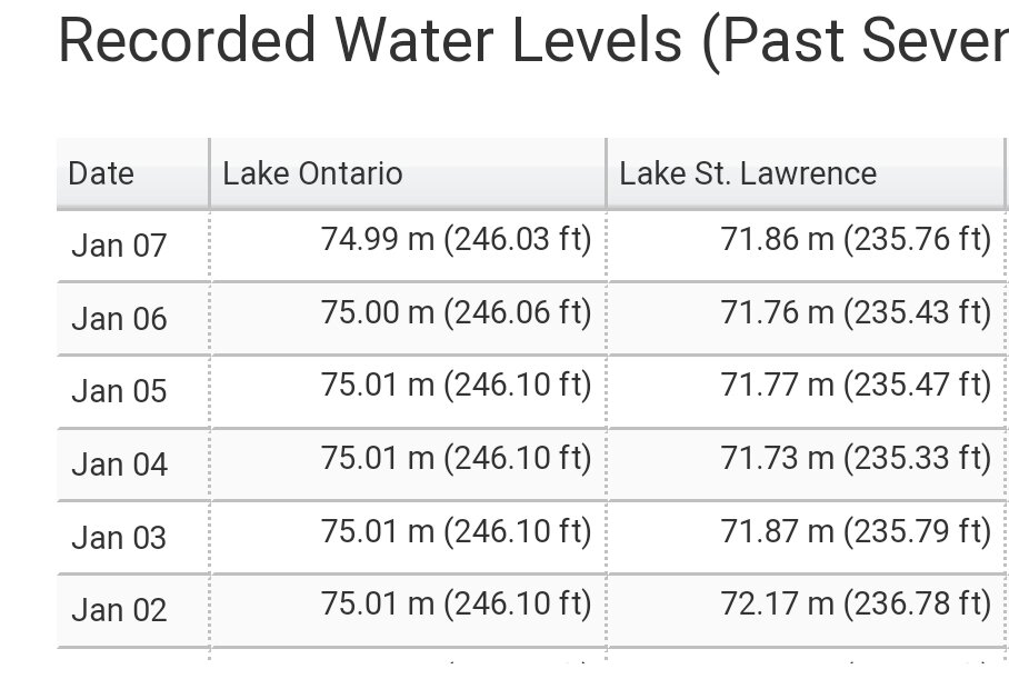
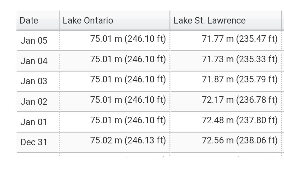
Lake st. Lawrence is holding steady at 235. Current has to be insane dropping 8 ft from ogdensburg to there but as long as its maintaining that depth they can keep it cranking. Hopefully warm weather persists so that can keep this up as long as possible. The rest of the great lakes are in rough shape.
https://www.fox2detroit.com/news/great-lakes-water-levels-could-be-even-higher-in-2020
-
Yea it doesn't take long. A stiff east usually drops flow big time on that river. That's the one that will leave you searching for a launch with water down below the dam. I've had the water drop so fast on Erie that we had our 20 foot duck rig go from floating in 2 foot of water to grounded up on the rocks high and dry in minutes with an east blow. On the other side stiff wests have forced me to have to have a guy jump off on shore and back the trailer down the ramp so I could power load the boat in the buffalo harbor many times over the years. Nothing like coming back to the launch to a dock that's now 2 feet under water. At least now they've replaced everything there with floating docks and a ramp that's big enough to account for water fluctuations. Those surges are no joke.Such a strong gere on east end probably helps to hold some water back from river.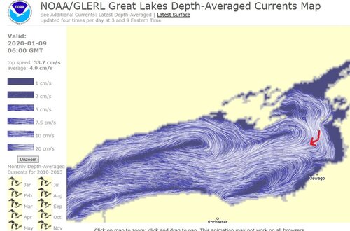
I've seen Vincent go up a good 12" & Rochester down the same, due to winds, in just a few hours.
Sent from my SM-G965U using Tapatalk
-
People forget it's not just a setting at the dam to get a specific outflow number. The outflow is calculated based on what comes through the moses sauders power dam, combined with what goes over the long sault spillway, and what goes through the massena and Raisin river diversions. Those numbers are all combined and they make up the "total outflow" number that we are given. That's how winds can effect flow, it's not just push the button to get a set number.
-
10 minutes ago, Todd in NY said:
Every bit of news coverage I see that talks about outflows from the Moses Saunders dam NEVER mentions the water levels on Lake St Lawrence, or the affects of higher outflows on Lake St Lawrence. It's like their only giving us part of the story, or the part they think people want to hear.
https://www.wwnytv.com/2020/01/08/water-outflows-unprecedented-rates-regulators-say/
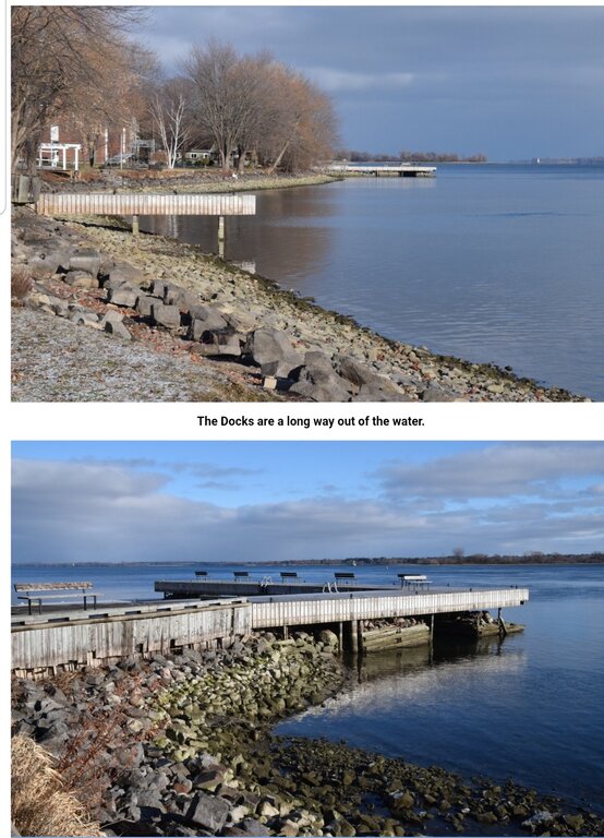
It is mentioned in there actually. Very last line. "Low water levels up river." Guess it's not the news they want to focus on. Hopefully somebody can get a drone up and get some footage from up above while it's this low, I heard some of the old roads are exposed and the water is low enough where the old homes that are still down there underwater would show up from up above maybe.
Its kind of big news up there to see the dam rip like this in January. They've never opened the long sault spillway like it is right now this time of year. Normally the area below that is the first to freeze. The long sault is the dam in the photograph used in the article. Idk I think it's cool to see anyway.
-
1
-
-
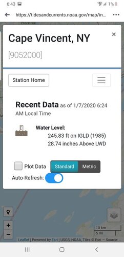
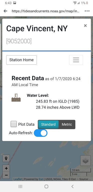
Yes. 100%. My post was relating water levels from cape Vincent to ogdensburg and then ogdensburg to lake st. Lawrence showing how the river drops as you head down river and how drastic the drop is at the narrows of the river right now compared to its gradient further east. That has nothing to do with the wind direction currently. Of course lake ontario levels fluctuate with the winds and its ripping out there right now. I've been listening to waves crashing all day.Look at todays gauge readings at Cape Vincent, Alexandria Bay and Ogdensburg. You can see when the wind direction changed from SW to NW.
Sent from my SM-G965U using Tapatalk
-
Stiff north west winds cause the water to drop the further west you go now? It's been exactly thr same for 5 days. You see the Cape Vincent graph? That's wind. The difference between ogdensburg and St. Lawrence? Yea that's not wind.Wow.What?
Sent from my SM-G965U using Tapatalk
-
What? Wow.Shows the effects of the wind on a larger body of water
Sent from my SM-G965U using Tapatalk
-
28 minutes ago, LongLine said:
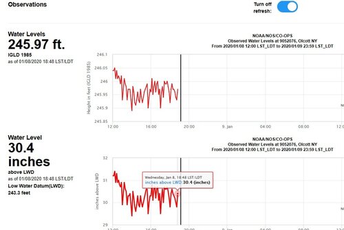
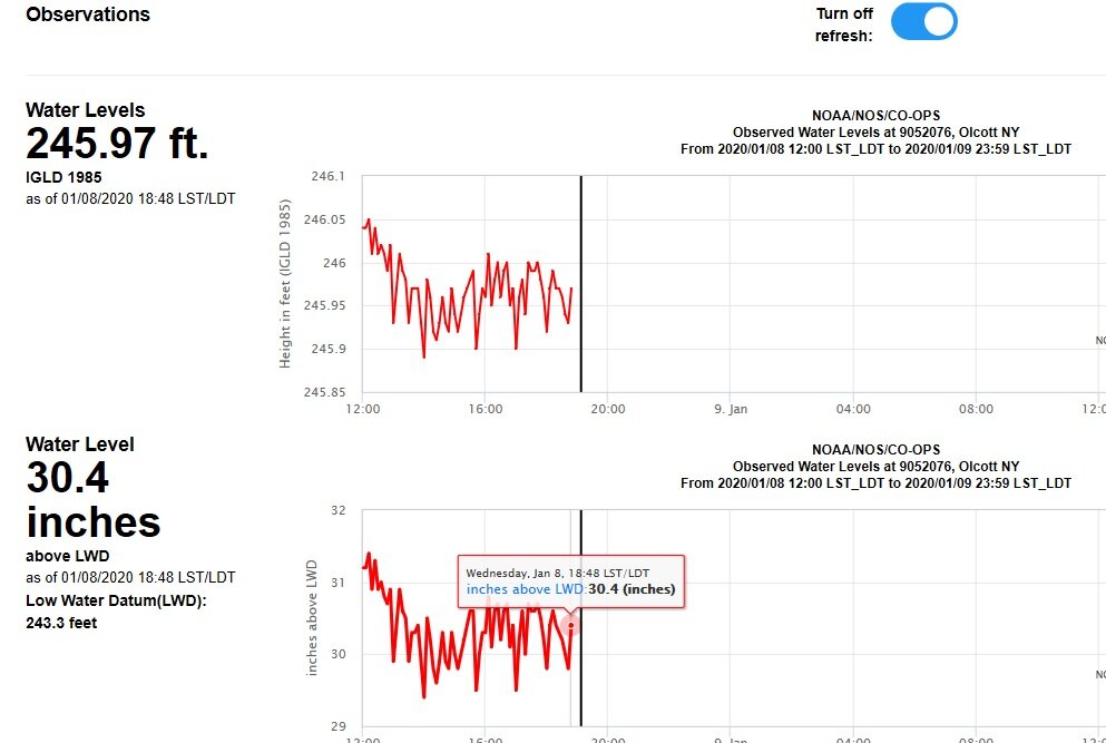
Olcott about 1/2 hr ago:
Longline those are the only live gauges I can find also. Lost a lure has access to live gauges on lake st. Lawrence but it's a couple feet off from what gets published the next day. He also has live outflow numbers also that we cant see publicly if we need them.
-
2 fit from Cape Vincent to ogdensburg. That's about 55 miles. Then a 9 ft drop from there to the Gauge in Lake St. Lawrence probably only 25 miles down river. Shows how restrictive the river is at that point.
-
7 minutes ago, Fishnut said:
They cost more to go up river with a high flow rate but aren’t they seeing a savings on there way out? ( going down river)
Sent from my iPhone using Lake Ontario UnitedThey claim costs are actually increased going down as well. Thrust and speed have to be increased for steering and they have to use tugs to assist in areas they normally wouldnt. I believe Chinook explained it all better than I can a few pages back.
I know personally when I launch at the dam many times I run 18-20 miles down to St. Francis proper to start fishing. With the high current this past year I gain a couple mph going down but I have to use considerably higher rpms to stay on plane coming up. Even in my 19ft glass skeeter fuel costs go up probably 20% or more making that long run at 4500-5000 rpms over the normal 3-4000. You know how that goes as a boat owner. Gallons per hour goes up exponentially.
-
On 1/7/2020 at 9:51 AM, lost a lure said:
Data from a gauge you probably dont have access to.
Sent from my SM-G950U using Lake Ontario United mobile app
Your gauge that I dont have access to is 2 feet different than the one that's used to measure Lake St Lawrence. Looks like they are managing flows to keep it at 235.

-
Yea just saying I dont have access to anything but public data. What is flow at now at the dam?I know the information you posted is public. I am talking about the numbers I posted
Sent from my SM-G950U using Lake Ontario United mobile app
Sent from my SM-G965U using Tapatalk
-
Nope. Just public data.Data from a gauge you probably dont have access to.
Sent from my SM-G950U using Lake Ontario United mobile app
Sent from my SM-G965U using Tapatalk
-
Your talking something the size of the west river of the Niagara through one of the most heavily populated places in canada to prevent something that's happened twice in 60 years. The river is miles wide in parts down there. It would make the seaway project itself seem small. Personally I think we've messed with nature enough. We arent always going to be able to keep the river within its banks no matter what we do. Look at the Mississippi and the devastating floods they experience even with limitless levys and flood gates along its entire stretch. Ma nature is just cunty at times and when we live here for the good, we have to deal with the bad. Hopefully it's a dry spring and all can return to normal soon.
-
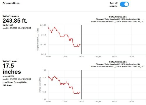
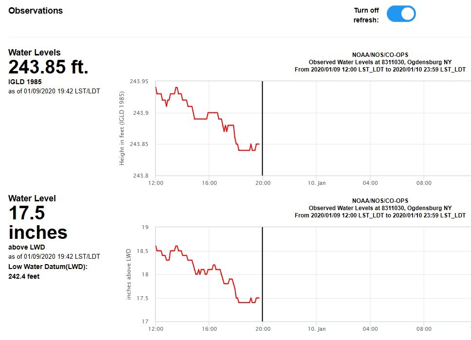
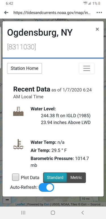
I found Ogdensburg levels finally. You can see how bad the river gets restricted at that point even with the floodgates wide open. Ogdensburg at 244 feet still. Just 2 weeks ago was about even with lake st. Lawrence. 2 days ago it was almost 10 feet different.

-
26 minutes ago, lost a lure said:
What is the current level?
Sent from my SM-G950U using Lake Ontario United mobile app
They havent updated in 2 days. It was steadily dropping almost a foot a day. If I had to guess I'd say 234. We will know this week. Residents are all saying its the lowest they've ever seen.
-
6 minutes ago, lost a lure said:
237.66 as of 6 a.m. 1/7/2020
Sent from my SM-G950U using Lake Ontario United mobile app
Ok I just looked it up and where did you find that number? I hasnt been updated since the 5th like I said and it was 2 feet lower then?? Ur telling me it went up 2 feet in 2 days? Did they shut the dam off?
-
1 minute ago, lost a lure said:
237.66 as of 6 a.m. 1/7/2020
Sent from my SM-G950U using Lake Ontario United mobile app
Thats good its slowed then. It went from 243 to there quick if you look. How much did they reduce flow? Hopefully they can keep it up another week or more without reduction for minimum or ice. The pics are really cool to see.

-
Just now, lost a lure said:
What is the current level?
Sent from my SM-G950U using Lake Ontario United mobile app
They havent updated in 2 days. It was steadily dropping almost a foot a day. If I had to guess I'd say 234. We will know this week. Residents are all saying its the lowest they've ever seen.
-
Just now, lost a lure said:
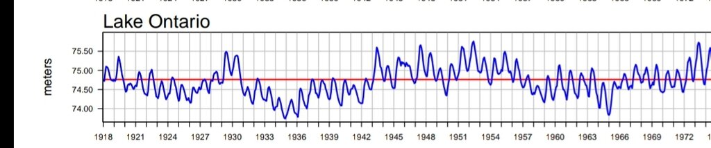
As I stated previously the Lake Ontario levels where both low and high before the seaway was built.
Sent from my SM-G950U using Lake Ontario United mobile app
Yes.. extremely high and extremely low.


MINIMUM BOAT FOR DEVILS HOLE DRIFTS
in Open Lake Discussion
Posted
Your gonna end up in a bad situation trying to salmon fish up there in a 16 footer. Water is still at summer levels during salmon season. What if you have to chase a fish between the plants? If you want to fish devils spend the 6k. It's not worth risking your life.