
Stillwater
-
Posts
292 -
Joined
-
Last visited
Content Type
Profiles
Forums
Events
Gallery
Store
Posts posted by Stillwater
-
-
Well I have some good news...
I have been working back and forth with a Navionics Customer Service representative and based on my input they will be making some improvements to the Navionics+ Eastern downloadable charts for the St. Lawrence River. The improvements will include the missing chart sections on the river just east of Chippewa Point / Oak Point area and also east of Ogdensberg Bridge. These areas did not have the sonar chart details like the Mobile App and Web charts. Also to be updated will be any missing Community Edits including ship wrecks, etc. Once these changes have been made I will notify on this thread so people with downloaded Navionic+ charts for the river can update their chips.
I also requested that the sonar chart contour lines be fixed / upgraded between Rock Island heading east to Chippewa Bay where they are broken and jumbled. They have opened 2 work cases for this and will notify me when it is complete and available for download.
I have been very pleased with Navionics responsiveness and the overall look and feel of their product for my Hook5 plotter.
Looking forward to fishing with it this summer. Hope your reset clears up your tracking delay Chowdaire.
-
Great video. Amazing how rocky and rugged the bottom is in the section near the channel. This area would be tough on fishing line and bottom bouncers!
Sent from my SAMSUNG-SM-G870A using Lake Ontario United mobile app -
That is not good. Have you talked to Lowrance about the delay? I hope they would do something about it. I only used mine once on the ice so I do not know if the gps will delay or not. If it has a delay they will be hearing from me.
Sent from my SAMSUNG-SM-G870A using Lake Ontario United mobile app -
I have read about that delay and you may want to check to make sure you have the latest software version. I think it was addressed in an update last fall?
Sent from my SAMSUNG-SM-G870A using Lake Ontario United mobile app -
Well I took the chip out of the Hook5 and downloaded a smaller area of lakes. This cut down the size of the download quite a bit. The download was for all 3 types of info: nautical charts, sonar charts and community edits (same as I did two times previous). Then I downloaded only the community edit updates on top of that.
I put the chip in the Hook5 and checked for the community edits like ship wrecks and fishing spots, etc. and low and behold they showed up but only with the chart set to Navionics (and not Fish - n - chip). This is the opposite from what you said you had with the Hook7 Chowdaire. Not sure why they would be the opposite but I have no edits with mine set on Fish - n - chip.
I am still not getting the same quality of contour lines that the mobile app map has for some sections of the SLR. Oh well it will be functional like it is. I still want to hear back from Navionics to see what they say. Seems like a software issue not a Hook5 issue?
Thanks for your suggestions guys.
-
Thanks Chowdaire, I do have it on Fish & Chip. I may try to down load again to see if that works.
Wallyandre, I was chatting online with Navionics service. They opened a case # for my issue. I will let you know if they resolve it.
Sent from my SAMSUNG-SM-G870A using Lake Ontario United mobile app -
Thanks for the reply. I did download the communiy edits and there wasn't very much from what I can see. No wrecks like on the Web and mobile app versions. The contour lines were bad as well as I mentioned. It would be nice if you could get the same quality in the SD card download as they have on the Web and mobile apps.
Sent from my SAMSUNG-SM-G870A using Lake Ontario United mobile app -
St. Lawrence River Navionics maps?
I picked up a new Hook 5 chart / sonar unit with Navionics+ east chip. Downloaded the maps for New York, Ohio, etc. including the SLR. Question for those who have Navionics+ for the river... Do you find there are stretches of the river where the contour lines are broken and uneven? I find that along from about Rock Island east to before Ogdensberg the map contour line quality changes a few times. Some stretches have smooth contours and others have choppy broken and more geometric looking lines. Also my mobile phone app has better quality map content and shows details like ship wrecks, etc. that my download to chip does not pick up.
Interested in what other people have experienced in terms of contour line detail and quality. Thanks.
-
Very nice! Congratulations and thanks for sharing the great pictures.
Sent from my SAMSUNG-SM-G870A using Lake Ontario United mobile app
-
Thank you for the update Kevin. Another effort seems to be in order!
Marty.
-
How has the fishing been in August so far? Thinking about trying again sometime between now and mid September. Thanks in advance for any reports.
-
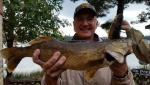
Great picture. Nice catch.
Sent from my SAMSUNG-SM-G870A using Lake Ontario United mobile app
-
Some really great eyes caught recently by Justin, Kevin and EsoxAC3 and from the photos they are biting in the daylight! Great job by all.
Sent from my SAMSUNG-SM-G870A using Lake Ontario United mobile app
-
Nice catch and in 20 minutes you had a very productive outing.
Sent from my SAMSUNG-SM-G870A using Lake Ontario United mobile app
-
Edit to my last post... Captain Bob Flavin. (no within same post edit using phone from what I can see).
Sent from my SAMSUNG-SM-G870A using Lake Ontario United mobile app
-
Thanks for the tips. I am at the north end. Hope to get out tomorrow.
Sent from my SAMSUNG-SM-G870A using Lake Ontario United mobile app
-
I interpreted their reference of it to a "feel good" stocking program to be sort of a high brow put down of the great work being done by concerned sportsmen. From some of the background history I have read about Captain Bob Flavia and Mr. Bouchard the DEC resisted them since the beginning in 1989. Not surprising they are not praising it now. Reluctant participation is better than none... I guess.
Sent from my SAMSUNG-SM-G870A using Lake Ontario United mobile app
-
Very Nice catch lyk2fish, how deep were you getting the bows? I may give it a try next week.
Thanks.
Hear of any walleye being caught on Owasco this year?
Sent from my SAMSUNG-SM-G870A using Lake Ontario United mobile app
-
Hat's off to all the SLR walleye stocking pioneers and volunteers. Unless some other data is shared it appears that the primary cause for the walleye population growth is this "feel good" stocking program.
Sent from my SAMSUNG-SM-G870A using Lake Ontario United mobile app
-
Thanks for sharing this. Learning a lot of great things about them. Roaming must be in their DNA?
Sent from my SAMSUNG-SM-G870A using Lake Ontario United mobile app
-
According to the SLR Valley Sportsmen's Clubs face book page they have stocked about 1 million walleye total so far. That has got to have made a major contribution to the overall population in the upper and lower river sections. Fish naturally love to swim upstream against the current. Ogdensburg stocked fish are probably migrating up river. Kevin's proposal for a tagging study would be able to confirm this for sure. Neat pictures of netting walleye to collect eggs.
https://www.facebook.com/St-Lawrence-Valley-Sportsmens-Club-218012358215701/
-
I have done a little looking on the DEC website and found a related "St Lawrence River Fish Communities" page. At the bottom of this page there are 3 links to .pdf documents. Take a look at the middle one labeled "2015 St. Lawrence River Fisheries Update". This contains graphs showing population trends for the major game fish species. It is interesting that the Walleye population really grew in the last 15 years. It peaked in 2009 and is currently looking like it is on the increase again. This may be in line with the stocking efforts for the SLRWA that has been underway. Glad to find this information. Looks like their are a couple more links within this .pdf with more background as well. Good rainy day reading. Good luck everyone. I hope to fish the river again in late August or September.
-
Congratulations on a great fish. Thanks for sharing. Is it your biggest ever?
Sent from my SAMSUNG-SM-G870A using Lake Ontario United mobile app
-
Maybe someone from SUNY ESF would like to take it up as a masters or Phd thesis project. You would think that the DEC fisheries at the Cape Vincent research site and world class research boats and equipment would jump all over this one. To me the walleye is a very unique and valuable game fish that still has a lot of unknowns surrounding it. This is an example of the gap in available science / information. The US and State government spends a lot of money to study many things that are far less useful and even wasteful. If you look at the DEC fisheries website they post their annual research and fisheries updates. This would be higher on the list than many that I have seen. Oh well. I did read that they were slow to get on board with the SLRWA efforts to help boost the walleye. Maybe a not invented here view?
St. Lawrence River Navionics maps?
in Walleye
Posted
Yes, I have a few photos of the spots where it goes from good sonar chart detail to poor detail. First area starts by Oak Pt. And goes east to Delack Pt. The next section starts by Chimney Pt. And heads east from there. See attached photos.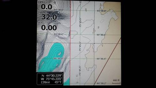
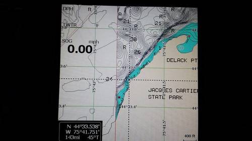
Sent from my SAMSUNG-SM-G870A using Lake Ontario United mobile app