
Shipwreckworld
-
Posts
21 -
Joined
-
Last visited
Content Type
Profiles
Forums
Events
Gallery
Store
Posts posted by Shipwreckworld
-
-
NOAA is proposing to designate the Lake Ontario National Marine Sanctuary (LONMS) in eastern Lake Ontario to recognize the national significance of the area's historical, archaeological, and cultural resources and to manage this special place as part of the National Marine Sanctuary System. On January 19, 2023, NOAA filed a Notice of Proposed Rulemaking on the Federal Register. Federal Register :: Proposed Lake Ontario National Marine Sanctuary; Notice of Proposed Rulemaking
NOAA in its Proposed Rules is looking to add layers of prohibitions and permits that would supplement existing section 233 of the New York State Education Law. This NYS law currently protects any object of archaeological, historical, cultural, social, scientific, or paleontological interest situated on, in, or under lands owned by the state of New York. In the Proposed Rules NOAA looked at the impact on the for-hire fishing businesses that operate in or on Eastern Lake Ontario. They stated, “it is assumed that this proposed rule would affect a substantial number of small entities." The Proposed Rules would also apply to fishing, boating, diving, research, and education.
Everyone should participate in the process by familiarizing themselves with the plan and expressing their views on it during the comment period and at the local meetings. We do not need more regulations, there are too many now.
Public meetings:
· Oswego, NY, Feb. 28 Lake Ontario Event and Conference Center: 6:30 p.m.-8 p.m.
· Wolcott, NY, March 1, Wolcott Elks Lodge No. 1763; 630 p.m.-8 p.m.
· Watertown, NY, Date: March 2, 2023, Jefferson Community College; 630 p.m.-8 p.m
-
Tall Tails unfortunately the information you have been told regarding the sanctuary preventing off-shore windmills is not correct. I am a member of the sanctuary Advisory Committee and have been in direct contact with New York State officials that would be involved in off-shore windmills. They have stated that the sanctuary would not prevent future off-shore windmills from being constructed.
The point of this post is not about windmills but the fact that NOAA does not want to be upfront with the public with their proposed regulations at the time they announce the plans for the Lake Ontario marine sanctuary and then submit them only after all public comments are closed in September. What sanctuary regulations is NOAA attempting to hide and from public comment?
-
The marine sanctuary designation would not prevent the development of off-shore windmills.
The Public Service Commission is in charge of decisions concerning windmills.
The New York State Office of Parks Recreation and Historic Preservation would also be involved.
This situation has been previously fact checked with NYS.
The point of this post is that NOAA does not intend to provide the public with their proposed regulations at the time they announce the plans for the Lake Ontario marine sanctuary and then only after public comments have been closed. That is not right so what regulations does NOAA want to hide from the public?
-
 1
1
-
-
Within a few weeks NOAA will post on the National Register their proposed plan for the Lake Ontario National Marine Sanctuary which covers a portion of eastern Lake Ontario and the St. Lawrence River.
We understand that NOAA will only post their regulations for the proposed sanctuary after the public comments have been closed in early September.
If the new proposed regulations for the Lake Ontario marine sanctuary are similar to those posted for the proposed Wisconsin marine sanctuary* then they will create the following:
1) Restrictions on fishing in areas near shipwreck and shipwreck wreckage sites
2) Restrictions and possible permit requirements for tethered devices which could include underwater drones, towed surveying equipment, fish cams etc.
3) Anchoring restrictions near shipwreck wreckage sites
4) Other restrictions still unknown to the public
By not publishing regulations with the proposed Lake Ontario National Marine Sanctuary plan, NOAA is preventing the public from reviewing and possibly objecting or commenting on them during the public meetings to be held in mid-August.
What is NOAA trying to hide from the public?
Please let’s hear your comments – we will pass them along to NOAA.
Or you can inform NOAA ([email protected]) directly how you feel about this decision to post regulations only after the time for public comments on the Lake Ontario National Marine Sanctuary plan is closed.
*Reference: Section 5.4.1: Proposed Wisconsin - Lake Michigan National Marine Sanctuary Draft Environmental Impact Statement and Draft Management Plan (windows.net)
-
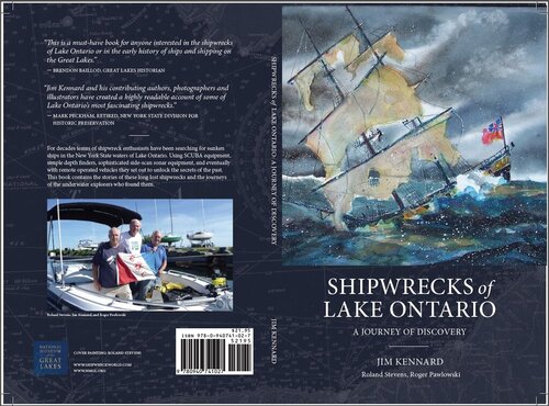
My new book Shipwrecks of Lake Ontario is now available. A special Rochester book premier event will be held on June 19th at 6:30PM.
For details on ordering the book and to register free of charge for the book event visit the shipwreckworld website:
http://www.shipwreckworld.com/articles/shipwrecks-of-lake-ontario
-
1
-
-
My guess is that this is an old channel marker which probably was off of the Niagara River some time ago and was dragged by the ice to this location. I have seen this before.
There are only a few shipwrecks that we have located in Lake Ontario that still have the mast still standing. We have found large trees and several high pinnacles of rock in some locations that protrude off the bottom that can cause a snag.
If anyone is curious about a snag you can email ( [email protected]) me the location and I can check out our side scan records for that area of the lake or go and check it out if we have not covered that area. See www.shipwreckwold.com for our shipwreck discoveries off of the southern shore of Lake Ontario. Cheers, Jim
-
Awesome stuff. I love your videos of these wrecks.
From a fishing perspective, do you ever see salmon hanging out on these wrecks at that depth?
Thanks for sharing,
Chris
Hey Chris,
Thanks We have not seen any salmon at those depths.
If anyone has seen a curious bump on their depth finder or has hung up on something in the lake I would appreciate hearing about it.
Please email me: [email protected]
All info will be kept confidential.
Jim
-
The British steamship Nisbet Grammer, the largest steel steamer to have foundered in Lake Ontario has been discovered by a team of shipwreck explorers thirty miles east of Niagara, NY in a depth of over 500 feet of water. The Nisbet Grammer was enroute from Port Colburne to Montreal with a load of grain when she was struck by the steamship Dalwarnic in a dense fog.
Read the full story with pictures and video: www.shipwreckworld.com
-
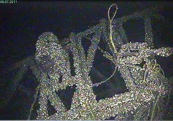
We saw a Steelhead swimming around the wreck. Estimated to be around 30 inches. No hangs seen on the dagger-board schooner wreck.
There are no plans to raise the ship.
-
Our shipwreck search team has recently discovered a rare dagger-board schooner in Lake Ontario.
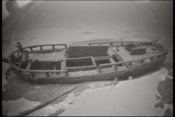
Read the story and view the pics and video on the Shipwreckworld website.
See: Early 1800's Dagger-board Schooner Discovered in Lake Ontario
NOTE: We are always interested in hearing from anyone that has hung their gear up on something or has observed a curious bump off the bottom.
Please contact me directly with information at: [email protected]
All communications will be kept confidential.
-
Great Lake Lure Maker: I am also finding it hard to believe that the temperature would be nearly 49 degrees. My experience as a diver is that over +100 ft depth in the early part of the season it is closer to 39 to 40 degrees. The ROV has had problems with the depth and temperature sensor over the past few weeks. It was just sent back for repair and calibration. Jim
-
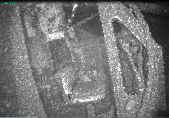
The houseboat is over +300 fow . Looking forward to getting more details for a story for Shipwreckworld.com. Will show the video . This houseboat wreck is a mess waiting to catch fish lines, anchors, and remote operated vehicles (never to return !!)
-
Thank you. Yes this must be the Chug -A-Lug. It is in over 300 ft of water. Perhaps they printed something about the loss in the Pall Times. When I have more information I will put the story and video up on www.shipwreckworld.com. Thank you to Tall Tails (Capt Brian) and Rustyrat for your fast reply. Jim
-
Recently we located a sunken houseboat or party boat north of Oswego with the name Chug-A-Lug.
We are interested in learning the details of the loss of this boat.
Video of the sunken boat will be put up on the Shipwreckworld website in the near future.
We would appreciate receiving any information on the Chug-A-Lug . Please send email to: [email protected]
Chug-A-Lug - stern
-
Thanks for the congrats everyone.
We have seen quagga mussels in depths as much as 600 ft. The quagga mussels are found in deeper depths and the zebra mussels in the shallower depths.
We have not seen hardly any fish in Lake Ontario on shipwrecks in depths much over 150 ft. And beyond 300 ft, I don't recall seeing any fish life. The temperature is around 39 degrees at those depths.
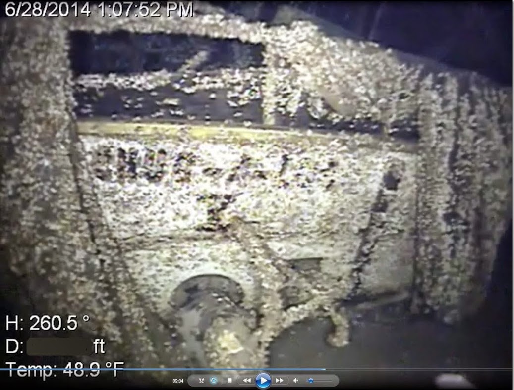
The company that lost the deck cargo was dissolved in 1993. A friend in the marine salvage business in Chicago told me that this was not the only deck cargo this company had lost in the Great Lakes while they were in business!! Jim
-
A lost deck cargo that we discovered this summer in Lake Ontario has now been identified.
Read the story and view the underwater video. No fish seen at this depth.
http://www.shipwreckworld.com/articles/ ... ke-ontario
Cheers, Jim
-
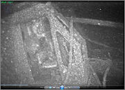
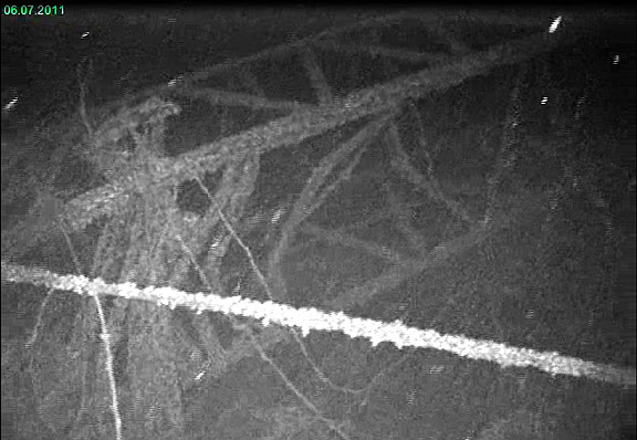
In early July, off of 30 Mile Point in 550 ft of water, we located a deck cargo consisting of two large crane sections, trailer, tanks, cable, and other assorted items.
Does anyone recall the details of when a barge loaded with this material may have been lost?
This cargo looks like it has been on the bottom for a long time, maybe up to 50 years. Actually saw a small fish around the crane at this depth.
See the images of the crane section including one with the cab:
-
I believe what is happening to your depth readings is being caused by severe thermocline.
This is a thin but distinct layer in which temperature changes more rapidly with depth than it does in the layers above or below.
The month of August is probably the worst month for thermo layers to occur in our lakes.
There might actually be several thermo layers in depth. This month the thermocline may extend down to around 85 feet or so.
The thermocline causes sonar signals to be reflected back because there is a density difference of the warmer and colder water above and below the thermo layers.
Your sonar is probably picking up the first strong return signal from this thermo layer and locking on to it as if it were the bottom.
If you have a temperature probe with a +100 feet of line drop it down slowly and you can observe where the thermocline(s) are located.
Hope this helps explain what you are seeing.
NOTE
Should you have encountered any bumps or hangs off the bottom of any lake please contact me.
I will check them out and post them on the WRECK FINDER portion of our website: http://www.shipwreckworld.com
-
I would like to ask the Lake Ontario fisherman, boaters, and sailing folks to contact me should you go over any curious bumps off the bottom of the lake or encounter any hangs.
Most likely these bumps are probably bait fish but there is always the possibility that one just might be a lost shipwreck.
I am part of a small team of shipwreck, fishermen, and sailing enthusiasts.
Over the years we have discovered a number of significant shipwrecks off of the southern shore of Lake Ontario.
We post the locations of many of these shipwrecks for divers and fisherman on our Shipwreckworld WRECK FINDER.
Knowing where shipwrecks or hangs are located can save your fishing gear.
Please email me directly should you have encountered any bumps or hangs off the bottom of Lake Ontario.
I will check them out and post them on our website: http://www.shipwreckworld.com
-
Name: Jim
Location: Fairport, NY
Home Port: Rochester, NY
Boat Name/Type:
I fish for: Shipwrecks
==================
I am part of a small team of shipwreck, fishermen, and sailing enthusiasts. Over the past 8 years we have discovered a number of significant shipwrecks off of the southern shore of Lake Ontario. See our website: http://www.shipwreckworld.com for articles and images of these shipwrecks. Earlier this year we launched WRECK FINDER on our website to provide both divers and fisherman the locations of shipwrecks in Lake Ontario. Knowing the location of a shipwreck can be helpful to avoid getting gear snagged in that area or it can provide a location where there will be fish to be found. As we locate or learn of more shipwreck locations in Lake Ontario we will continue to post this information on the WRECK FINDER portion of the Shipwreckworld website.
I would like to ask the community of fisherman, boaters, and sailing folks to contact me should you happen to go over any curious protrusion off the bottom of the lake or encounter any hangs. Many protrusions will probably be bait fish but there is always the possibility that one just might be a lost shipwreck. We have the general locations of over 200 shipwrecks that are still believed to be in the lake spanning a period of nearly 200 years. Some shipwrecks were lost without any known location. A short description of what you saw (depth, etc) and your guess at the location, or even better the GPS co-ords would be appreciated. I will update the WRECK FINDER on Shipwreckworld as new information comes forward. Hopefully, this will be a good aid to all that need to know where gear could get hung up in the lake.
Please contact me directly at: [email protected]

NOAA is proposing new rules to restrict fishing and the operation of underwater drones over shipwreck sites.
in Open Lake Discussion
Posted
Windmills are not out. We have confirmed that with New York State.
If the marine sanctuary were approved NOAA would provide information regarding the underwater resources within the proposed area for windmills.