

LongLine
-
Posts
3,873 -
Joined
-
Last visited
Content Type
Profiles
Forums
Events
Gallery
Store
Posts posted by LongLine
-
-
Saw maybe 6-8 cormorants swimming & diving in 165 FOW on Thurs off Long Pond. Also maybe 2 dz small alewives swimming in circles on surface, obviously wounded. Didn't mark any pods though. I always thought those birds were better hunters.
-
Canadian law does not require periodic monitoring of effluent as US law does. That's a big reason that the Hamilton harbor spill happened. No one checked for the gate that was left open over many years! Expense is a big reason they're not going to dredge that creek where it happen, and cleanup the 20 billion liter spill that has been draining into the lake. Wonder why Hamilton harbor has had those algae blooms?
-
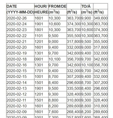
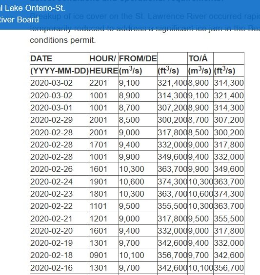
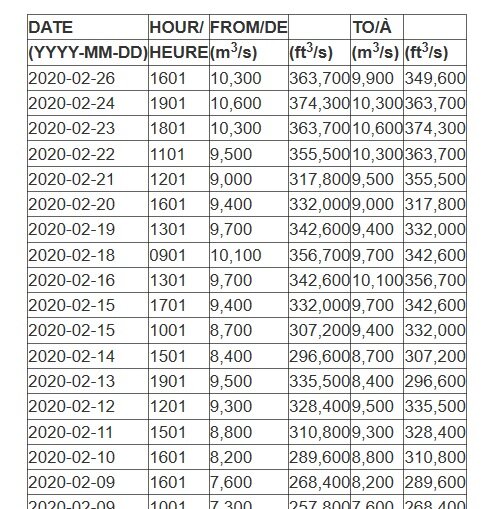
The Niagara is naturally choked by that shallow section above the falls. (i.e 1500 wide x 17 ft deep) Falls site/people say 168K cuft/sec is what they want for high tourist hours in summer but Buffalo water keeper says average has recently been around 210K Cu ft/sec. St Lawrence can flow considerably higher. What really hurts are the additional smaller rivers that really add up. i.e Rochester currently at 12K, Oswego at 17K & Lord knows what the Ottawa is throwing at the big river. They need to keep the St Lawrence well over 300K
-
-
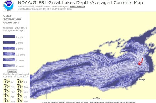
Check out the MODIS imagery of the lake. Erie is green & so is the south shore of Ontario yet offshore & northern shore of Ontario is dark. GL Currents map shows pretty strong easterly currents along the southern shore and strong westerly currents along the North shore so you know where the Erie water is going.
-
Higher runoff, seems to me, logically leads to more "stuff" being washed in the lake. Question is "what's the stuff?" - Good "stuff" or bad stuff?" Articles that I've seen indicate a rise in pharmaceuticals & plastizers. Obviously NYS phosphorus ban in soap & fertilizers has helped reduce phosphorous loading from NY side but what about the effects from Lake Erie & the Canadian side?
Erie has algae blooms, which I believe have been blamed on phosphorus loading and the Canadians don't have Federal laws like the US does concerning secondary wastewater treatment nor the same fertilizer laws. I remember a few news articles about raw municipal waste being dumped directly into the lake because treatment plants overflowed in Canada. It's also my understanding that only a few Canadian cities have waste water treatment anything like the US has. (I'm thinking Kingston & Windsor) Hamilton being the most guilty polluter on Lake Ontario.
But back on point -something to think about: lake Ontario has very wicked gyres, (circulations, hence mixing - with offshore generally a little slower than nearshore) especially in the winter time. (which has been reversed at least once this winter according to the GL Currents monitoring website) Therefore I would think that high water levels would have a diluting effect of pollutants from the other two main sources, on phosphorous & water quality studies. i.e same or greater tonnage of "stuff" but much more water. (I don't know how many "gillions" of gallons 3 ft or 4 ft of surface water represents)
Come on Spring!
-
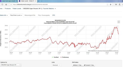
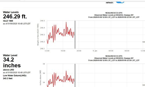
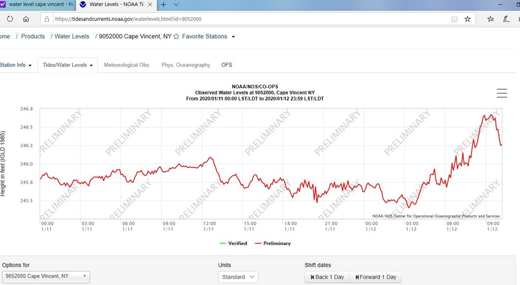
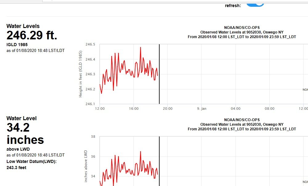
Currently bouncing 246.2 to 246.5 at Rochester.
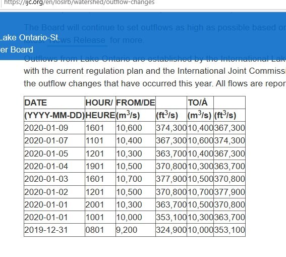
Recent Outflows:
Tom B.
(LongLine)
-
Just remember to lower a stacked rigger slowly, so the lines don't tangle.
-
7 to 10 ft for me
-
-
So those fish in the pic came into the cone and then dove way down...right?
-
At 3 am Cape Vincent at 245.4. At 8:45 am 246.6.
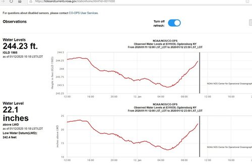
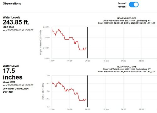
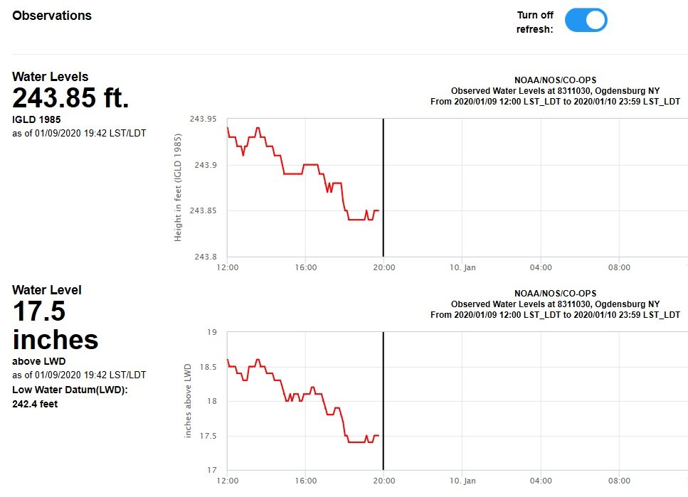
At 5:12am Ogdensburg at 243.4. At 10:18am at 244.2
winds greatly affect current flow. Gyre back to normal direction this time of year but current very strong. Near 20cm along S shore.
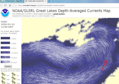
I'm sure waves on top of that level & gyre doing damage. Probably a lot of spray ice
-
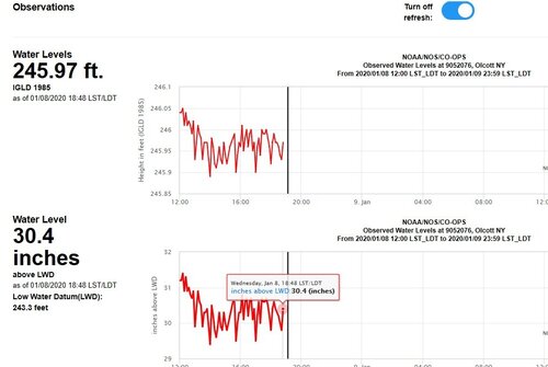
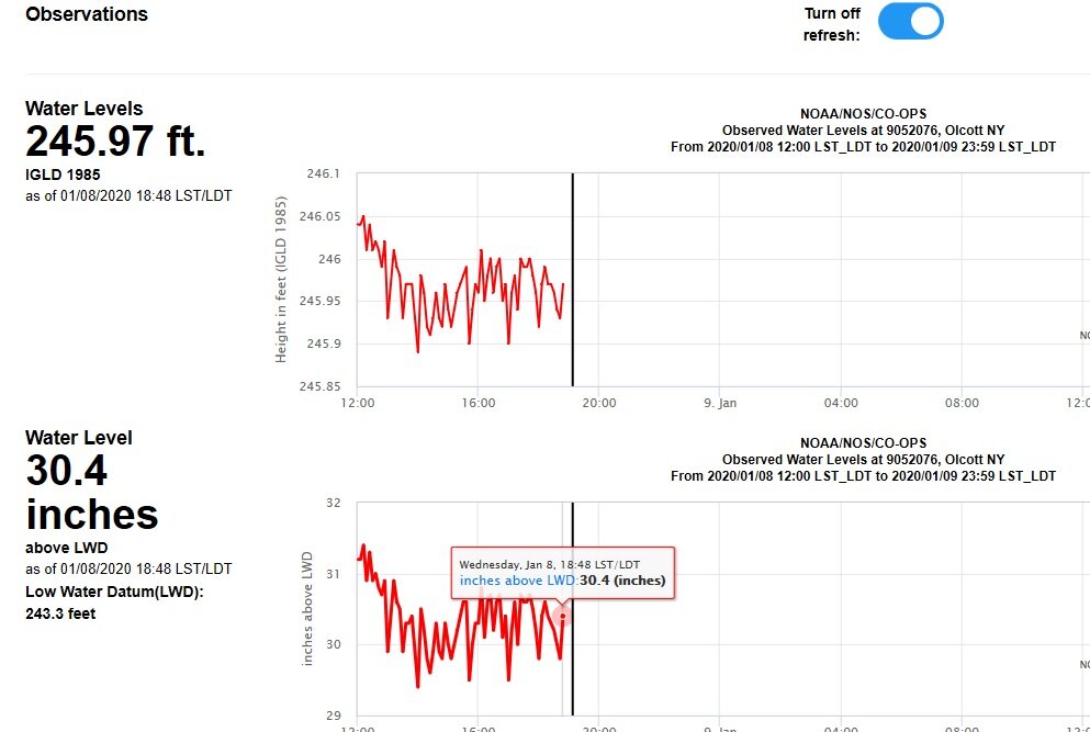
At 7:48 water level at Cape Vin was 245.73. At Olcott was 246.24. That's a 6" difference with ENE wind at only15 knots.
-
1 hour ago, horsehunter said:
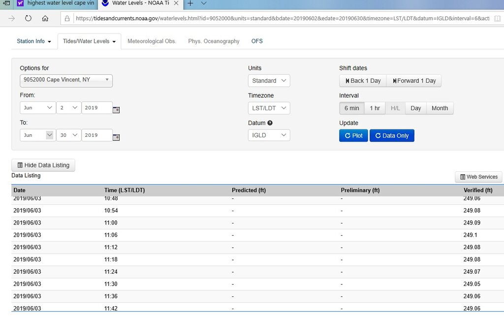
Does anyone know what the maximum level reached in 2019 and when for the east end of the lake?
June 3, 2019, max was 249.1 Ft at Cape Vincent.

July remained in high 248's, Aug stayed in low to mid 248's
-
gyre going back to normal (counterclockwise)
outflow:

Ogdensburg
-
Marks on fishfinders can be interesting to interpret. If I was seeing a lot of marks like the one on the left and the center, I'd check the angle that the transducer makes to the water level as my boat sits on the water. Thinking that it was tipped backwards too far. I'm having trouble visualizing in 3-D how a fish can be first seen in the cone shallow then go deeper. (unless he was dive-bombing towards the center of the cone) If tipped too far backwards then the first two fish could have been swimming horizontally but perpendicular away from your boat. (hence further out of the cone) If a perfectly vertical cone passes over a stationary fish, it will show up deeper then appear shallower then deeper again. Like an inverted arch. (checkmark). If he was coming up from the bottom then the mark would start deep then go shallower. i.e mark sloped the other way than on your screen. Someone help me on this?
Also remember that length of the mark does not necessarily mean length of fish, rather it means he spent a longer time in the cone. i.e. the one on the right was probably a follower.
-
Such a strong gere on east end probably helps to hold some water back from river.
I've seen Vincent go up a good 12" & Rochester down the same, due to winds, in just a few hours.
-
Rigg'rs & 320's … Don't leave home without them.

-
Fish will come out of temp often. If you see followers, shorten a lead on at least one rod.
-
I've run solo for a long long time. (with 8 1/2's) With any rod, after you've lost your 1st two decent fish, you'll have learned what you need to do to get them in the boat.
-
 1
1
-
-
I replace every year. I also cut a bunch off after a decent fish.
-
Welcome to the nut-house. I'm in room 220.
-
1
-
 2
2
-
-
Olcott about 1/2 hr ago:
-
Oswego about 1/2 hr ago:


Snakehead or Bowfin?
in Open Lake Discussion
Posted
yep, Bowfin.