
Beards247
-
Posts
15 -
Joined
-
Last visited
Content Type
Profiles
Forums
Events
Gallery
Store
Everything posted by Beards247
-
 Nice! Puttered around Henderson Bay, turned a few perch in Henderson Harbor. Nice 18' smallie out by the islands
 -
I worry about Wescotts opening to the lake. It's typically shallow, so low water would be even sketchier.
-
IMO the best option is Henderson b/c it has the floating docks - but not sure how far you will have to back in (i.e. close to the drop off edge of the cement ramp). I can't speak to Jefferson County launch, but Sackets was OK for launching, but bring a freaking step ladder to get in and out of the boat at the wall.
-
Updated the spreadsheet with this weeks numbers. We gained .07 or almost an inch this week, 8 inches since March 20th the first time they cut the outflow.
-
I was able to launch pretty easily last week, but getting in and out of the boat was more of an adventure than I thought.
-
Thanks for posting @mudflat Updated the spreadsheet just to say I did - a little pointless since there was virtually no increase in water level. Howling at the moon - but I'd love to see an explanation of changes. And, the average outflow for this time of year is 240k - why are we 260K or higher? We should be average or below. If the pattern holds from previous, the reduction in flow on 4/10 should add about 2.5 inches in a week. They post new numbers on Thurs or Friday so we'll see. Hopefully the rain this week is heavy enough to add some too. Today's rain in Syracuse was only a soaking rain, no real run-off.
-
The surest way to be proven wrong on the internet is to claim you are right, LOL. Of course Erie Inflows, trib/rain, and St.Lawrence will change that guess. So each week I'll plug in the actual numbers from the previous week and re-guesstimate. These are the sites I use, gives data of the past week (updating on Thurs or Fri). Thanks for posting yours. https://ijc.org/en/loslrb/watershed/water-levels https://ijc.org/en/loslrb/watershed/flows I wish they'd release explanations for each outflow increase/decrease - I want to believe they are smart engineers/scientists, but increasing the St. Law outflow now seems really stupid.
-
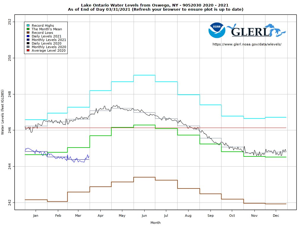
It looks like the IJC releases updated water data on Friday's. Since the St.Lawrence outflow was cut to 260,600 on March 20th, LO water level is going up on average .03 inches per day (.083 = 1 inch), with a couple rain events added, in 2 weeks LO has added almost 5 inches, but still over 1/2 a foot lower than average for this week. So from the low on March 20, I guesstimate LO will add at least 1 foot by April 19th and 2 feet by May 20th which will put LO in-line with seasonal average water levels. Which still seems low to me, but the previous 3 years were 2-3 feet above average water levels so I think my perspective is off. * Guesstimate assumes St. Lawrence outflow, Lake Erie inflow and tributary/rain do not change. Actual numbers will account for any changes. I'll aim to update this weekly on Saturday updated numbers (grey shaded is guesstimate) https://docs.google.com/spreadsheets/d/1HJfG1WgxjrmZQ7HSjEdZxiaEUThlU02Spb9JzMFSM3c/edit#gid=0
-
 According to the official measurements, 2.6 inches March 22nd to March 28th. Just under 1/2 inch per day (.43 inches). Be interesting to see how long they keep the LO nozzle pinched for.
 -
I hope to find out this weekend, plan on playing off of your good idea and taking pics of the launches.
-
It is the difference between water levels March 22 and Mar 28 from the table at the top of this page. Water level on Mar 22 was 244.32 feet (bottom left of the table), Water level on Mar 28 was 244.52 feet (top left of table) Difference of .20 feet, which is just short of 3 inches (.25 would be 3 inches) * * 12 inches in a foot, so a quarter of that is 3 inches, or .25. If you wanted to see more than a weeks comparison, the interactive graph at the bottom of the page shows this year compared to high low averages along with 2020 and 2019 data.
-
This website does a great job of showing LO current water levels, changes to outflows and the forecast range based on wet average or dry conditions. According to those charts LO is only 8 inches below average... it sure seems lower than that. Maybe the past 3-4 years of high water has changed my memory. Like @mudflat said, outflows have been cut and the lake has gone up (almost) 3 inches in the last week. Hopefully they can keep that trend going. @Seaox23 thanks for the link. All the great lakes are down.
-
Thanks for the pics of the launches - I agree, I don't think Henderson will work for my boat either (similar size/style to yours). I had been thinking I'll be using East launch at Sackets b/c at least that's deeper... but I think the cement ending will be an issue there too. FWIW, Re: IJC... the GL region from Huron to Ontario has had 2 consecutive seasons of low precipitation (Last summer and Winter) and likely a third, this Spring. All of the great lakes are low or way below averages for this time of year. IJC has been bone headed and needs to be changed, but this isn't their fault. It's just Mother Nature.
-
for sale : usa Storm thundersticks, Smithwick's, rapalas
Beards247 posted a topic in Classifieds - Buy, Sell, Trade or Rent
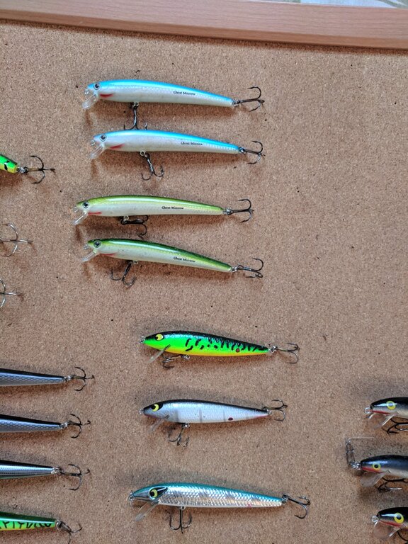 Go here for more details on contact info https://syracuse.craigslist.org/spo/d/cicero-brown-trout-lures-smithwick/6884066035.html
 -
Initially, I thought about just getting another basic unit to replace my ailing 10 year old Garmin 240 Blue. Humminbird has a monochrome that also has Down imaging Humminbird® 581i HD DI Sonar/GPS Combo or the Lowrance® Elite-5 DSI Sonar with GPS for about 400. Staying with MonoChrome is no biggie - my eyes are still good and it's worked fine for 10 years, so color isn't a functional improvement, but that side imaging... that really interests me but that also means stepping up in price/functionality. Here's my summary of research so far. I've read many forum posts about who likes DI vs SI, and mostly those with experience use DI mostly but SI is great for getting to know new water quickly. Since I don't fish a lot, getting to know water quickly is valuable. So far the features that interest me in order of importance: A reasonable price to feature ratio 2D See structure and fish Ability to watch vertical jigging (as a friend demo'd on his HDS 5) Mark spots on a map (ideally Add/manage/delete spots and tracks on computer) SI - review water faster and mark interesting spots DI - greater detail on what's down there Expandable Chart Capabilities Video input (LW 9 Insight) Make my own maps ---- Great feature, but not relevant for me ---- i-link with MinnKota trolling motors (HB) Also, which manufacturer... Humminbird vs Lowrance. I've read quite a bit and seen the staunch advocates on each side. Somewhere in the reading someone likened the debate to Ford vs. Chevy, which is probably about right. I came away with the general perception that HB's learning curve is easier compared to LW, but LW offered more flexibility and maybe (though hotly contested) better sonar readings. HB seemed to provide better customer support, but there are reports LW is trying to catch up in this area. From my own observations, LW also costs more when comparing feature set to feature set. So I went to Bass Pro Shops in Auburn. By far, the coolest ones were the LW touch series, 9-12. Fast, sleek, and with every feature on my wish list, sorta. For 2400.00 bucks you can get the base model, but only the 2700 bundle gets you the Side Imaging feature. That touch screen however, is fantastic - I could have played with it for hours. Humminbird's 9 series lacks the video input (but does have video output) and lacks that incredible touch screen, but has a much lower price point - 1500.00 (and apparently a hack for custom maps). That amount will still dip into my beer budget for a long time but my waist and fishing will probably benefit from it - assuming I pull the trigger. So far Old Blue streaks and all is still on the boat. What do you guys use? What features to use most or like best?
