

lost a lure
-
Posts
1,237 -
Joined
-
Last visited
Content Type
Profiles
Forums
Events
Gallery
Store
Posts posted by lost a lure
-
-
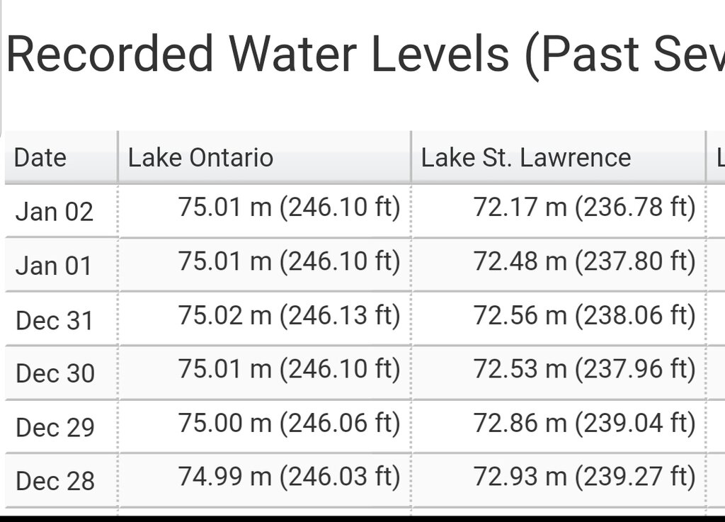
The level on the upstream side of the Iroquois Dam only fluctuated up and down approximately 4 inches from this A.M. to P.M. with the wind change and approximately .5 inches on the downstream side. If you look back when the levels where higher the wind affected the levels more.
-
Look at todays gauge readings at Cape Vincent, Alexandria Bay and Ogdensburg. You can see when the wind direction changed from SW to NW.
-
12 minutes ago, iiwhistlerii said:
What? Wow.
Sent from my SM-G965U using Tapatalk
Wow.What?
-
1 hour ago, iiwhistlerii said:
2 fit from Cape Vincent to ogdensburg. That's about 55 miles. Then a 9 ft drop from there to the Gauge in Lake St. Lawrence probably only 25 miles down river. Shows how restrictive the river is at that point.
Shows the effects of the wind on a larger body of water
-
Don't tell anybody I told you, but the flow is 10,600. Not sure if they posted it yetYea just saying I dont have access to anything but public data. What is flow at now at the dam?
Sent from my SM-G965U using Tapatalk
Sent from my SM-G950U using Lake Ontario United mobile app
-
I know the information you posted is public. I am talking about the numbers I postedNope. Just public data.
Sent from my SM-G965U using Tapatalk
Sent from my SM-G950U using Lake Ontario United mobile app
-
Data from a gauge you probably dont have access to.Ok I just looked it up and where did you find that number? I hasnt been updated since the 5th like I said and it was 2 feet lower then?? Ur telling me it went up 2 feet in 2 days? Did they shut the dam off?
Sent from my SM-G950U using Lake Ontario United mobile app
-
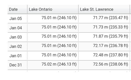
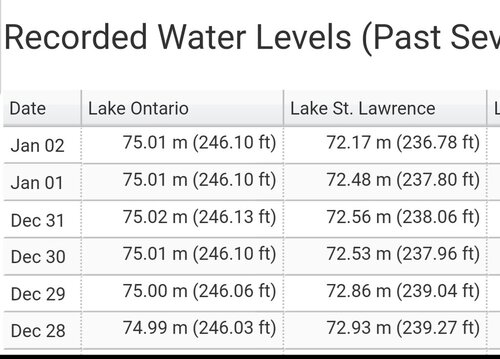
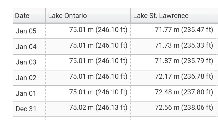
237.66 as of 6 a.m. 1/7/2020They havent updated in 2 days. It was steadily dropping almost a foot a day. If I had to guess I'd say 234. We will know this week. Residents are all saying its the lowest they've ever seen.
Sent from my SM-G950U using Lake Ontario United mobile app
-
What is the current level?231 feet and change before it effects water supplies
Sent from my SM-G950U using Lake Ontario United mobile app
-
As I stated previously the Lake Ontario levels where both low and high before the seaway was built.Iroquois dam isnt the bottleneck. Iroquois dam was put in place after they eliminated the worst part of the bottleneck and created the locks. That whole area used to be Rapids before they created the seaway and the lakes. Have you ever looked at water levels prior to the seaway? Yes lake Ontario could have been much higher at times without the flood control and ability to even out flows using the lakes reservoirs .
Sent from my SM-G950U using Lake Ontario United mobile app
-
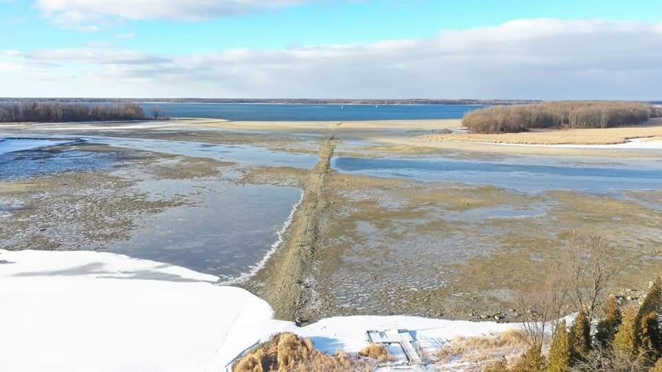
What is the "set minimum" for Lake St. Lawrence?From the army corps of engineers web site. Or how about the fact that water went from the docks to 200 feet out this week at Wilson hill and Ogdensburg hasnt changed at all. You think these pictures are fake? Lake Ontario is at 246 and holding and lake st. Lawrence should hit set minimum by the weekend.
Sent from my SM-G965U using Tapatalk
Sent from my SM-G950U using Lake Ontario United mobile app
-
9 hours ago, iiwhistlerii said:
So lake Ontario and the upper st. Lawrence is at 246 feet and holding and Lake st. Lawrence has gone from 243 feet to 235 feet this week but u want me to believe the difference is only 11"??? Did lake Ontario drop 8 feet too?? Can you see chimney shoal out of the water in Ogdensburg??


Sent from my SM-G965U using Tapatalk
Where did you take your measurements?
-
6 hours ago, iiwhistlerii said:
My point is if you look at it from all angles I honestly feel like it's been pretty equal. People from lake Ontario argue nature wouldnt have saved them if the dams werent there. They forget that same argument applies here. Have you ever looked at the lake ontario levels from before the seaway was built? Nature would have washed away their property 40 years ago without the seaway stabilizing lake levels.
Long term health of the lake is impossible without natural shorelines and natural erosion. Armoring the entire shorline and eliminating natural seasonal flooding will slowly but surely turn this lake into an empty lifeless swimming pool.
Sent from my SM-G965U using Tapatalk
Levels were both low and high before and after the seaway was built. Would the 2019 level have been as high without the dams? According to your theory the flow would have been higher when the water level was higher, especially without the Iroquois Dam "bottleneck"
-
19 hours ago, iiwhistlerii said:
My argument is that flows cannot be sustained above what they were without dropping lake st. Lawrence. Remember your whole iroquois dam argument? Well the dam has been wide open all fall and Lake st. Lawrence just dropped 7 feet in 7 days under these flows. You call that sustainable? If they didnt absolutely prove my point for me idk what will explain it to you any better. You wanted to see that in october? Dont worry, most launches and docks are only a couple hundred feet from water there now. Would have been fine. Oh but none of that matters to you because you dont live on that portion of the river. Your part is all that matters. I'd love to see how your tune would change if u were a few miles northeast.


The open the Iroquois Dam comment was to provoke a response from anyone who knows how it actually works or thinks they do. I never said the high flows were sustainable without the level of Lake St. Lawrence dropping. Once again "none of that matters to you because you don't live on that portion of the river" are your words not mine. My tune is not changing no matter where I live.
'
-
7 hours ago, iiwhistlerii said:
So lake Ontario and the upper st. Lawrence is at 246 feet and holding and Lake st. Lawrence has gone from 243 feet to 235 feet this week but u want me to believe the difference is only 11"??? Did lake Ontario drop 8 feet too?? Can you see chimney shoal out of the water in Ogdensburg??
Sent from my SM-G965U using Tapatalk
11" below lwd and the drop in water level are two different things. Lake Ontario did not drop 8 feet. You can see part of Chimney Island shoal.
-
As of 05:00 1/6/2020 Lake St. Lawrence is 11.42" below lwd down stream of the Iroquois Dam. Sent from my SM-G950U using Lake Ontario United mobile appMy argument is that flows cannot be sustained above what they were without dropping lake st. Lawrence. Remember your whole iroquois dam argument? Well the dam has been wide open all fall and Lake st. Lawrence just dropped 7 feet in 7 days under these flows. You call that sustainable? If they didnt absolutely prove my point for me idk what will explain it to you any better. You wanted to see that in october? Dont worry, most launches and docks are only a couple hundred feet from water there now. Would have been fine. Oh but none of that matters to you because you dont live on that portion of the river. Your part is all that matters. I'd love to see how your tune would change if u were a few miles northeast. -
5 hours ago, iiwhistlerii said:
Do a google search man. Its public knowledge and common sense. I even lose 6mph on top end trying to go into that current and it takes me 4000 rpm to stay on plane where usually I can do it at 3 when I'm just cruising into the current. Nobody wants those rapids below the dam. You argue the shipping industry wants lower flows but then argue they want higher water. Guess what, those 2 things dont go together. With higher water come higher flows, they definitely dont want this.
Sent from my SM-G965U using Tapatalk
I did not argue that the shipping wants lower flows or higher water. Those are your words. When are you going to realize that major corporations don't tell the truth about their profits? What happened to your argument about the water flows could not reach 10,400?
-
9 minutes ago, iiwhistlerii said:
Yes.. 3-4 million per day loss in business revenues. BUSINESS REVINUES from the SHIPPING INDUSTRY.
And who is telling the Standard what to print? The shipping industry
-
1 hour ago, jimski2 said:
39 posts, all about out flow rates. What about the Lake Ontario in flow volumes? Your concerns about out flow rates are meaningless unless you have the numbers on Lake Erie flow rates along with canals and tributary flow volumes.
Sent from my iPhone using Lake Ontario United mobile appWe have those numbers. Nothing can be done about the inflows. The outflows are higher than inflows now.
-
Flow increase from 10,300 to 10,400 on 1/5/2020 at 12:01.
-
Flow was lowered from 10,500 to 10,300 at 19:01
-
I did in no way imply that you were making up the messages. Simply stated that it was funnier than Hanks comment and you turned it around.
-
5 hours ago, iiwhistlerii said:
Far less entertaining... plus I've gotten multiple messages from guys on the site commending me for taking on the impossible task of convincing those scorn that there may be more to this than they are willing to see. Lots of people appreciate the info and like to learn how the system works whether they chose to agree or not. We are all adults, as long as people dont start taking things personal it's all good educational banter.
Multiple messages commending you. That's funnier than Hanks snowball comment.
-
 1
1
-
-
11 hours ago, iiwhistlerii said:
Oh and please tell me again about how they slowed flow in august to help shipping and not because lake st. Lawrence was beginning to drop without the water being as high. They tapered down the flows as flow from lake Ontario slowed as it dropped. Here is what happens with 249 ft flows when we are at 246ft... lake st. Lawrence losing a foot a day and at a historical low that would have went over real well in August. Lake ontario is holding steady as water is working it's way through the bottleneck of the river. Probably at about 8,000, it's natural drainage rate for this level.
Flow was decreased on 12/28 until 12/31. Lake St. Lawrence level decreased.

Is there hope ?
in Open Lake Discussion
Posted
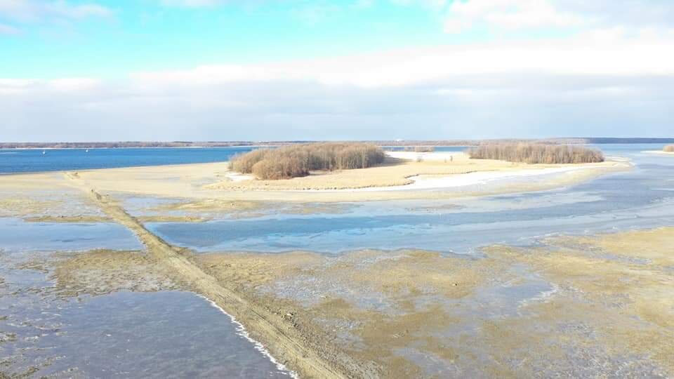
Some old stone foundations are visible and the old roads.