

Andre wallyandre
-
Posts
880 -
Joined
-
Last visited
Content Type
Profiles
Forums
Events
Gallery
Store
Posts posted by Andre wallyandre
-
-
That is from my App but it's exactly the same:
-
So it seems it's not the Simrad that is responsible but more likely you're boat electrical system.
-
Take a look at this short video it may help you to scroll faster in the menu; if that video doesn't help take a look on the Lowrance yotube for some more tips:
-
On 10/12/2016 at 8:20 PM, samcastoff said:
hds 10 with structure scan module an lss1 transducer, power cords, cover.. like new ....900$ wilson ny 716-471-5545
Excuse for the direction that you're post went.
The Structure Scan 1st generation is something that the bass fisherman are always looking for.
-
Did you update it with the latest update?
http://www.lowrance.com/en-US/Software-Updates/Elite-60/
What kind of problem do you encounter?
-
3 hours ago, pap said:
Hell ya thanks, for the heads up, they probably are swamped with Lowrance products since C.S. Is just about worthless!! I have Lowrance products but I can guarantee you one thing it's my last!! When our military is using Raymarine!! If they used Lowrance from my personal perspective, let's see, they would need to leave on constantly, when it's not froze up, it's only takes about 5 minutes to lock onto 15 satellites where most others use 32, if they used 32 you'd need to activate it before your first coffee of the day. One would need to take a 6 month class on how to operate the damn thing, my toilet paper is thicker than Lowrance's instruction manual. LOL those of us who own on can relate to my words, it would take a tech nerd to jump right in the drivers seat of these units. I've heard the touch screens are much easier?
Witch Lowrance model are you running?
-
1 hour ago, MikeyP said:
Good to know since Lowrance won't service the generation 1 units any longer.
It's even difficult to get a television fix after 3 years and there is a lot of those electronics things that just can't be fix.
-
Hydraulic is maybe the ultimate but going hydraulic then AP it becaomes very expensive so I think going with the Cable steer ap from Lowrance is something to look.
http://www.lowrance.com/en-US/Products/Auto-Steering/Outboard-Pilot-Cable-Steer-Pack-en-us.aspx
-
If you are using a Lowrance Gen-2 you could get a Lowrance AP for a cable system. They do have one for hydeaulic and one for cable steer
-
More related to the simnet network or the data wires are not in the right connector
-
Are you sure the autopilot computer is powered? After verifying correct polarity have you moved the fuse to the correct position?
Are you sure the SimNet wires are connected to the correct terminals?
Is the SimNet configuration correct with terminators at the right positions?
Also double check the SimNet connections at the autopilot computer terminal block, maybe even cut the loose wire end, strip the outside insulation back and redo it. Could be that one of the small wires got nicked and is preventing communications or causing an intermittent fault.
Did you connect the red and black wires in the SimNet cable to the corresponding terminals on the AC42? These are the "Net-C" and Net-S" wires for powering the SimNet backbone with 12V. You should not have two 12V power sources on the SimNet. Try leaving your other SimNet power source connected and disconnect the red and black SimNet cable wires at the autopilot computer terminal strip.
-
Start with this but the last sentence in red was the problem the guy encounter with his AP-24
Did you check fuse on the computer?
I can put a lot of infos but I'm pretty sure it's related with the Simnet but ore likely the data wires
- SimNet not configured correctly
- Simnet not terminated correctly
- Simnet voltage too low
You need one connection from the fuse panel to the SimNet backbone.
Figured out had data wires in wrong port on terminal there is a spare terminal in there.
-
The Simrad AP-24 is consider the est AP on the market.
When you say: it doesn't work; could you elaborate a little onwhat is not working?
Link with NMEA2000 or NMEA0183?
-
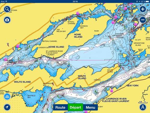
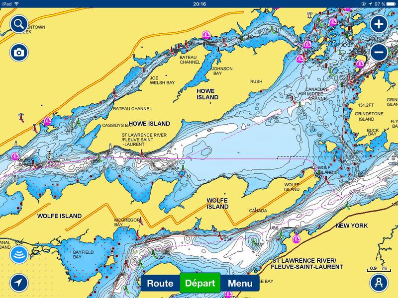
I fish mostly Lake Champlain, lake Ontario in spring for browns and the St-Lawrence river from Montreal and Three Rivers around a 60 miles stetch and the Navionics are very accurate except in certain very shallow area and I always run my Navionics app link by wifi with my Gen-3 so a couple of weeks later it's all done and I don't care sharing my finds. But that is me.
I also chart 4 new lakes last summer so the guys that use a Navionics will get a map for those lakes. That's my nature to be generous and this is why I'm sharing a lot over the net but they are things that I keep for myself specially my 10lbs walleyes spots.
-
Purchased hook 7 may . Sonar worked plotter was not working properly.
Lowrance Navionics took 3 months to correct.
Check out Furuno. Much better units.
The problem related with the plotter has been corected on 10/26/2016 with this update:
http://www.lowrance.com/en-US/Software-Updates/hook-software-20/
No CHIRP with the Furuno
-
If Navionics were so much of a junk they will not stay on the market!
-
With the new software coming you can create you're map and the datas are recorded on you're Navionics card; if you decide not to share it's easy you just don't update you're card.
You can get a bundle with the HOOk series and the Elite Ti
-
Id recommend a unit that allows you to make your own map. You will find features that arent on any map, especially on the st lawrence.
Justin Okrepki
NYSDEC licensed guide #7324
http://www.otiscolakeguideservice.com/
(607)-349-1750
On the next update from Lowrance you will be able to draw you're map directly on you're Lowrance. It will be possible with the Gn-3, Gen-2 Touch and Gen-2 non-touch.
-
With any map supplyers the rivers are quite often not chart or poorly chart but for the St-Lawrence it is very accurate.Using a Gen-3 you can improve the maps by linking you're Gen-3 to a smartphone using the Navionics App ($15 for the app) and once you update you're app and you're Navionics+ everything will be updated and more accurate.
Take a look at the last link in my post; https://webapp.navionics.com/?lang=fr#boating@9&key=mwhmGr_loM
-
Navionics+
But some model are coming in bundle; bundle mean that you can get a Navionics+ much cheaper when you are buying a bundle. Any idea on what brand & model Santa will bring to you?
http://www.navionics.com/en/navionics-plus-2
Don't know exactly the area you are fishing but you can get a idea of what you are getting by looking at the webapp:
https://webapp.navionics.com/?lang=fr#boating@9&key=mwhmGr_loM
-
The problem that you mentionne was real but is been corected with the latest software update found here:
http://www.lowrance.com/en-US/Software-Updates/hook-software-20/
Plus you will benefit of the CHIRP technology. There is a built-in map but if you want something better you can get the model: 000-12666-01 With that one you are getting a Navionics+ card. You may pay $50 more but you are getting a $150 card value.
http://www.lowrance.com/en-US/Products/Fishfinder-Chartplotter/hook-7-en-us.aspx
-
Here is what is coming out for Lowrance Live Mapping with SonarChart Live- What I know so far, subject to change…
➢ See below for effected units.
➢ Lowrance NOS 56 software update.
➢ Lowrance Units covered are-
• HDS Gen 3 12, 9, 7 Version 4.5
• HDS Gen 2 Touch 12, 9, 7
• HDS Gen 2 12, 9, 7
• Elite Ti version 2.5
• Lowrance Carbon
➢ SonarChart Live data recorded in Lowrance and displayed live on screen.
➢ SonarChart data is not recorded to the hard drive of the sonar, it is recorded to the Navionics card and Navionics card is required. (See below for required cards).
➢ Create High Definition 1’ contours.
➢ Requires a Navionics mapping card with an active chart update subscription (Freshest Data).
➢ Navionics Cards needed-
• Hotmaps Platinum
• Platinum +
• Navionics +
• Navionics + Regions
• Navionics Updates
➢ Data recorded in Lowrance and stored on card is not shared to Navionics.
➢ Genesis / Lowrance nor Navionics gets NO LOGS or Data from Lowrance Plotter/Sonar. Data not shared.
➢ Adjust SonarChart contour density.
➢ Update Navionics Mapping card in Lowrance Plotter via WI fi connection between Mobile device and Plotter.
➢ Download updated charts and transfer routes and markers/waypoints via the innovative Plotter Sync capability of Navionics Boating apps without having to remove the Navionics card.
➢ If you choose to do SonarChart Live and want to update your Navionics SonarChart data on card or mobile device app you have to connect affected Lowrance Units via Wi fi to Navionics Mobile app and do SonarChart Live in the mobile device, which is then uploaded to Navionics and processed into the community SonarChart layer. You then do a Freshest Data update to card or mobile device.
➢ Added functions-
• You can do plotter sync.
• Shallow Water Highlight.
• Depth Highlight.
• Easy View.
• Transparency.
• Navionics Dock-to-dock Autorouting creates intelligent, detailed routes, even through narrow passages and channels. -
Image on a good quality 7" will always look crisper on a 7" vs a good quality 12" and also if you are running a gen-2 12" the screen is not has crisp then a Gen-3 that is like the Elite Ti
If we compare apple to apple the Garmin and the Elite share a 7" 800X480 so they should be quite similar
Garmin antenna is a 5Hz vs 10
With the Garmin you got to live with the Garmin only choice map and w/o all the capabilities of the NK 2000 on the Elite and again Garmin is w/o the touch screen
-
Now in 9" & 12"
Take a look:
navionics
in Open Lake Discussion
Posted
Option then View and enable FishN Chip. When FishNchip is enable you loose the buoyes