

iiwhistlerii
-
Posts
407 -
Joined
-
Last visited
Content Type
Profiles
Forums
Events
Gallery
Store
Everything posted by iiwhistlerii
-
 Over and over I get the impression that more than 1 person here believes the IJC is somehow "backing up" the whole system. If this is what you actually believe it's time for you to seriously take the time to read about how water passes through the great lakes system. This is like having to explain to a college kid how babies are made. It's not a stork dropping the little bundle of joy on your porch I can tell u that.
 -
You actually believe that slowing the flow in the st Lawrence and lake Ontarios water level has any impact on the water levels on the other great lakes? What do u think they are slowing down Niagara falls? Is this actually what u believe? Please take the time to research how the system works before replying again. That's embarrassing.
-
Or because it rained. Feel free to explain why Erie, Huron, Michigan Superior and St. Clair are higher for any other reason.
-
I love it. The Ottawa was so high it was at risk of dam failure most of the spring and did have levy failures in multiple places and somehow you manage to dumb that down to 2". Sad. You gripe about the 30" high that we were. Well guess what, we are down to 18" over average thanks to the increased flows. You know who's still 30+" over average? Erie, St. Clair, Michigan and Huron. All lakes who's water levels are left to mother nature to decide. Crazy!! How could natural lakes be that high from just weather!? Good chance theyll all be higher over long term avg than ontario is again this year.
-
Tom I'm not sure what planet you are even on anymore. 2"? What on avg for the year? It's a river that rapidly rises and falls. When it's high it's high and then it drops. Water lines on the Ottawa were 9 foot over normal in spots. Litterally water to 2nd story roofs in spots. Please take the time to look at images and read the news from the past 6 months before responding. This is getting old.
-
Tom I really wish I could ignore facts and what is going on around the rest of the great lakes as well as you can. Ottawa broke records for flow, flood level and length of time above flood stage this year. Multiple times actually and in ever area of the river. Especially below the carillion dam. Keep ignoring the things that contradict your argument tho that's fine.
-
You cant because it's never been this high. Thus record. Same with lake Erie residents, also at record. Same with huron and michigan, same with st. Clair, same with the Ottawa. You seeing a trend here?? All at record levels. Plan 2014 isnt to fault here is my point. Natural levels would be much higher and levels with the previous practices would be exactly the same as what they are now. 2014s new parameters and practices havent even come into play yet and we are chopping off peoples heads without actually doing the research and making the comparisons that would actually assign proper blame. I dont know these people, if I had taken all this time to read what I've read and see what I've seen and thought for 1 second I could blame it on someone controlling a flood gate I would put the blame squarely where it belonged. It's just not the case. Sent from my SM-G965U using Tapatalk
-
Lol. Nope. Avid fisherman who's spends about 120 days a year on the water here on the great lakes. I spend my days from lake st. Clair, Lake Erie, Georgian bay, Niagara River, lake ontario, The st Lawrence and the Ottawa. It opens your eyes to what is really happening when you get to see it from all angles. I spent almost 40 days below that dam this season between july and Nov. I've spent a lot of time between massena and Montreal in the last 10 years. Its pretty obvious to anybody who's been down there that flow is increased and water has been higher for the last 3 years. With all that being said I live in Niagara county and I can hear the waves of lake Ontario from my back porch. When you observe it from all angles and do the research it changes your opinion on the situation.
-
Spot on comparison. A bunch of people ignoring facts hoping to effect regulation on fear based bs and not actual circumstance. Sad. Sent from my SM-G965U using Tapatalk
-
Let me know where on any graphs you see all time record highs on all the great lakes above lake Ontario and an all time record high on the Ottawa (that shares much of the same weather that affects our drainage basin) at the same time... oh yea, you wont, because this set of circumstances is unprecedented. 2014 doesnt just allow for higher highs. It also allows for lower winter lows. That seems to be the part everyone wants to ignore. Sent from my SM-G965U using Tapatalk
-
Omg it has nothing to so with shipping this time of year. They need high water levels for the ships down below. Winter water levels are for safe ice formation on the river itself. They never "close the gates", normal power production allows for a natural flow through the river. Using the spillway to increase flow has to be done responsibly just as it has been for over 50 years. When we keep putting up unreasonable solutions with faulty logic and poor understanding of the overall system we look like idiots as lake Ontario residents. You watched the water come up just as Lake Erie watched thier water come up and residents of ever great lake watched the water come up. It's a 300,000 mile drainage basin. Precipitation is to blame. Sent from my SM-G965U using Tapatalk
-
Feel free to use that logic to explain the same high water levels on every other great lake. Apparently anyone with an IQ of more than 6.5 should know environmental factors can't cause this.[emoji849] Feel free to explain that to those living along lake Erie, Superior, Huron, Michagan and St. Clair who don't have anybody to throw blame at but mother nature. Sent from my SM-G965U using Tapatalk
-
Exactly. It's all a cycle. We've been here before experiencing the highs and in a few years we will be griping about the lows. I just hope everyone redesigning docks and launches are keeping that in mind this time. It gets old listening to chicken little in panic mode all the time. The sky isnt falling. Sent from my SM-G965U using Tapatalk
-
These statements arent fiction. I'm not sure why everyone feels this is a conspiracy. None of this currently effecting shipping. That argument doesnt even come into play in this situation. They been dumping water as fast as safely possible since last winter. I can attest to this as I spend much of my time fishing the area around cornwall island and lake st. Francis. Water levels there have been kept much higher in the fall the last 3 years than they were in the previous 10. Everything effects water levels down below, wind, rain, outflows. It's very temperamental and water release is constantly monitored and adjusted to try and maintain a stable level and not wipe out entire islands on st. Francis or areas of montreal.
-
The example of an event caused my mother nature is right there in front of us. All of the great lakes are dealing with this, some worse!. What better example do we need as proof that mother nature is causing it? Also again, flows are currently at safe maximums until ice forms and solidifies. Ice up below cornwall isnt far off. This is common practice to keep water levels below the dam steady during ice formation for safety. It's nothing new and has nothing to do with plan 2014 Sent from my SM-G965U using Tapatalk
-
We dont control lake levels on the upper great lakes, mother nature does. So how do we prevent lake shore flooding there? We rely on mother nature and adapt. There is no "plug" here on lake Ontario. We modified our outflow in a way that is far from natural. We dredged shallow areas of shallow Rapids to create the seaway and dammed up and created slow moving lakes/reservoirs out of what once was a wild flowing river. Currently we let out as much water as possible without negatively affecting those who live along the "drain" below the dam. Right now the "plug" is pulled. Water is being let out at a natural rate, it's always being let out at atleast a natural rate. Plan 2014 actually allows us to let out more during the winter months than the previous plans did if you take the time to actually read how the changes work. It allows for lower lows each winter here on lake Ontario to keep the area below the dam higher because traditionally we've let the lower st Lawrence drop so low in the fall they cant even use thier boat launches to get thier boats out by November. With current water levels plan 2014 doesnt really matter, its parameters are out the window and they just scramble to let out additions water whenever they can. Everyone wants the spillway open earlier, or maximum flows year round like they did theoughout the summer to occur at other times of the year but it's just not possible without negatively impacting others far worse than the negative impacts we are experiencing here. You cant just let everything loose in march when half the river is still ice covered down below or when flows on the Ottawa are at peak levels. The impact down there is far greater than people realize. Water levels can and do rise 10+ feet and if we were to increase flows as the ice let's loose the ice jam flooding could be catastrophic to those areas. People keep complaining we didnt do enough all summer but none of them actually have spent anytime fishing below the dam and seen that water levels have actually been way up over where they traditionally have been for 3 solid years. Basically it all comes down to one thing. When every single great lake and water shed in the north east is at record water levels we are foolish to believe that lake ontario should not be at record levels. It's like believing ur neighbor to the north got a foot of snow, the one to the south got a foot of snow but you should be able to see ur grass still. It just doesnt work that way. If everything both above and below is higher than ever, guess what, so are we. What can we do at this point? Pray for a dry spring and a little reprieve from mother nature and keep in mind it's not just lake ontario fighting this battle and we arent even the ones being effected the most by the situation. Id love to be able to jump on the boat with everyone else and impulsively blame the IJC and plan 2014 but when I sat down and read everything and then took the time to analyze all the available data and compare it to the years past it really is the only logical conclusion. The implementation of plan 2014 in 2017 and the fact that in coincided with record lake levels is nothing more than coincidence.
-
Record levels.... Just about everywhere.
-
I'm not sure what I'm even arguing here. 66 and 67? Not even close to previous records. The all time record high for 3 out of 5 great lakes is 2019 and most of them set all time monthly highs throughout the year as well. The data is available and clear and many many articles have been published on that data. I've posted the graphs you referred to as reference. 2019 smashed all time records. Instead of comparing 2018 to current lake levels let's compare the long term average... superior +14, michigan/huron +37, st. Clair +30, erie +36 and ontario is at +18. Every one of these lakes dealt with the same problems we did all summer long, somebody them higher water levels, greater populated areas, bigger cities, more damage and for a longer period of time. You know who they have to blame, mother nature. The ships you keep referring to are running from the ocean to Montreal. You think they are holding water back now to make sure they can make it to Montreal? I just dont understand the current thought process. I understand plan 2014 will in fact let out more water and allow our winter levels to go lower in order to keep that portion high enough for those ships when needed but none of that comes into play with the conditions the past 3 years. Those ships are from Port of Montreal to the ocean only. Theyd never make it through the seaway any further. I keep presenting factual data with references to back it up and you keep telling me it's wrong without any facts. It's a very confusing argument.
-
-
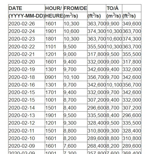
You can see here where we are today compared to the other great lakes. Lake ontario has actually faired better than the rest since July thanks to the water that was let go over the long sault all summer. Everyone needs to remember that theres nothing natural about the "drainage" that occurs as water leaves lake ontario through the st. Lawrence anymore. We created multiple reservoirs out of the river when we dammed it up and dregged massive areas that were once shallow rapids allowing more water to flow through those areas if left unchecked. Theres nothing "natural" about just letting the water go now. We have to regulate it to keep tolerable levels both above and below the dams.
-
Frogger look at the lake levels of the other great lakes from this summer. We werent even the highest over normal. Right now we here on lake ontario are one of the lowest over normal. Everyone has been feeling this since 2017. For some the impact has actually been much much worse.
-
Todd in everyone of my posts I've stated facts and every rebuttal has been to tell me my facts are wrong. I stated lakes had all reached record highs, I was told I was wrong, I stated current water temps and actual reasoning for keeping steady water levels in the lower st. Lawrence this time of year, again was told I was wrong. I was even told I was wrong about the shipping channel depth above Montreal. Facts stacked on facts to help explain why things are done the way they are and why none of it has anything to do with plan 2014 because we havent reached scenarios where its parameters even come in to play yet. All I get is an argument about ships coming into port of Montreal which have nothing to do with any of this. I get that everyone is upset with the current water levels but everyone is dealing with them from Superior to Quebec city. In the end we've spent 100 years armoring shorelines and destroying an ecosystem. I understand the lake ontario stocked fishery thrives as we dump them in by the millions but the native fisheries that truly depend on natural spawning grounds and back bays on the st. Lawrence can only be helped by this experience. We are experiencing natural high water just like everyone around us, the nutrients being washed into the lake will help baitfish to theive. New spawning grounds will be created as a result of shorline changes and backwater bays being flushed and brought back to life are all something we should be happy about as outdoorsman. You can only put walls around the lake and treat it like a swimming pool for so long because eventually all you'll have left is an empty lifeless swimming pool.
-
8.2 m above Montreal. Like I said, I've observed 27ft in the channel. Those ships will never come above Montreal without dredging and plan 2014 hasnt even come into play yet with these water levels. Take off the tinfoil hat and look at facts.
-
-
Tom once again you're forgetting that the whole world doesnt revolve around lake Ontario. Water temps at Montreal are 36. Water temperatures directly below the long sault dam spillway in pollys bay and the area above Hawkins point are only 34. Harbors and bays froze up on both the upper and lower st. Lawrence days ago and that area below the long sault dam will be solid very soon. When the flows are up for summer and over 10,000 they are letting water spill over the spillway on the long saulte dam. This time of year the area above Hawkins point is a bay of trapped water sitting below the long sault dam as they dont let water rage over the spillway this late in the season. All the water being let through at this time of year will come through the moses Saunders dam below Hawkins point. In the summer the water level in that area can fluctuate 6+ feet in an average day and sometimes even more. It's very much like the area occupied by our power plants in the Lower Niagara. Allowing the water to fluctuate down there that much daily creates horribly dangerous conditions with ice this time of year. Thus winter water levels coming into play on Nov 1st and lasting until April 1st in these areas. Last I knew the shipping channel above port of Montreal is only 27ft deep in spots so unless they start dredging we never have to worry about seeing any type of panamax on lake ontario.

