
dremarquis
-
Posts
498 -
Joined
-
Last visited
Content Type
Profiles
Forums
Events
Gallery
Store
Everything posted by dremarquis
-

"heads up" on the Woodville launch (Canandaigua -south end)
dremarquis replied to Sk8man's topic in Finger Lakes Discussion
hey Les, thanks for the heads up. I wonder if there are still some rocks in all that muck. Last year i ruined a prop at about 2-3 mph about 15-20 yds from the ramp. dre -
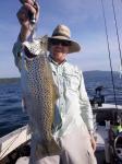
that 3rd photo looks like a monster steelie - how much did it weigh? andre
-
where to buy twillie tips?
dremarquis replied to dremarquis's topic in Questions About Trout & Salmon Trolling?
thanks everyone! andre -
 everyone - thank you so much for all your input - you guys ROCK! Sk8man wrote: I think that because of a variety of real life situational factors not taken into account in most of the chart info I've seen (e.g. directional current forces/speed, type of attractor and lures combined with a diver etc.) a lot of the info on the charts is questionable at best. I think Les is right on with this, but i still like to have some charts as a reference point, and steelydan and others really helped me out thanks again, dre
 -
I've been running my wire dipsey rods without twillie tips and need to get some, but i can't find them anywhere - even on the web. Does anyone know where i can order some? thanks, dre
-
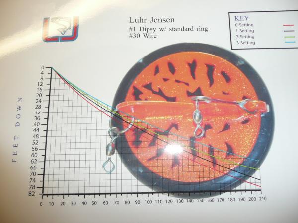
Hi all, i had my first 2 trips of the year on lake O yesterday and today and they were great (by my standards). Sat - went our of sandy creek and caught 6 kings (up to 32#) and 3 steelies (up to 10#) 400-500fow and some on wire dipsey (size #1) on a 0 setting out 300 feet. today i went out of i-bay and got 4 kings - all low to upper 20s - around 200 fow all on on wire dipsey (size #1) on a 2 setting out 330 feet. the dive charts i have stop at 150 feet of line out does anyone have a dive curve/depths for the #1 dipsey (ideally for settings 0, 1, 2, & 3) and also ideally for wire - i know the charts that come with the dipsey are less deep that the same feet out with wire. if you don't have such a chart, can you estimate how deep a wire dipsey (size #1) on a 2 setting out 330 feet is? and a wire dipsey (size #1) on a 2 setting out 330 feet? thanks very much, andre
-
 HI All, i mostly fish the fingerlakes but like to hit Lake O at least once each year for some bigger fish. I usually fish out of sandy creek. my experience is that the bite is usually very early and then not much else happens after 9:30 or 10a. Is that your experience too? I'm wondering if i should fish all day or do what i normally do (fish from first light till 10 or 11a then call it a day) thanks, dre PS - from reading the posts, it seems the temps have been moving a lot - any idea what depths the kings are now/tomorrow?
 -
you're funny Chuck! that's a good ideer, only that prize money is already gone - a new VRO fuel pump, new head gasket, new truck and trailer tires more than ate it up!!!
-
Hi all, i have a humminbird 570 that won't power up. I know it's the unit and not connections, because i have one on each boat and the other unit works on both mounting brackets. Humminbird charges a $75 service fee to repair it. Do any of you know of someone able to do such repairs and if they are cheaper than that? thanks, andre
-
i heard someone say recently (with regard to the hydrilla in cayuga) that the hydrilla could ruin the bass fishery there. that seems pretty unlikely to me because i grew up bass fishing in texas and the best bass fisheries there were FULL of hydrilla - i mean thick with it (30 fow and you could nearly walk on it). We would not only fish the edges, but use plastic worms with 1 oz weights - drop it right in the stuff and pull out LOTS of 6-9# largemouths (40# line and NO drag) perhaps things are different in a colder climate? i doubt it. I think it's the home owners who don't want it around their docks and water skiers etc who don't like it. I'm not saying they don't have a point, but i do not think hydrilla hurts bass - i think it helps. andre
-
 thank you VERY MUCH!!!
 -
precision trolling question
dremarquis replied to dremarquis's topic in Questions About Trout & Salmon Trolling?
Thank you John! -
does anyone have the dive curve for Rapala Taildancers (especially the 30' taildancers, but also 20' & 15')? i have the 6th edition of Precision Trolling, but i think that was published before Rapala came out with the Taildancer. if you could post or email me a PDF of any of those dive curves (the 30' is what i want the most), i would really appreciate it! thanks, andre
-
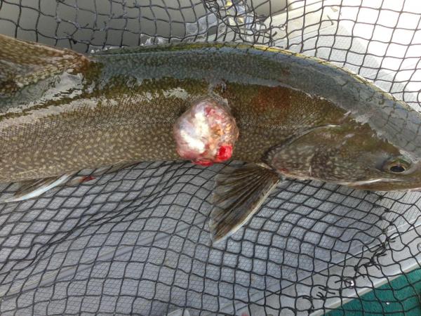 So i took the laker with the lesions to the region 8 DEC and Pete (forgot his last name) talked to me. I am very disappointed with the whole thing. He said he didn't think it was anything serious, probably a virus with a secondary infection (which manifested as the 3 lesions). I asked him if he'd take the fish to do pathology work on it and he said he wouldn't because they don't have a lab there! I am surprised they wouldn't send it to a lab to determine whether or not it was something serious or not. Let's hope he was correct and it wasn't anything too serious. Gambler - where did you catch the 34# laker? dre
 -
I was fishing Canadice yesterday and caught a 3-4# laker that had 3 nickel-quarter size lesions on it. I fish Seneca a lot, so i know what lamprey marks look like, and i am quite sure these were not from lamprey. I don't have time to post pics at the moment, but i put the fish on ice and am taking it to DEC in a few minutes. 2 sick fish from hemlock and canadice in a few days has me a bit concerned.... dre
-
Canandaigua woodville lauch update
dremarquis replied to dremarquis's topic in Finger Lakes Discussion
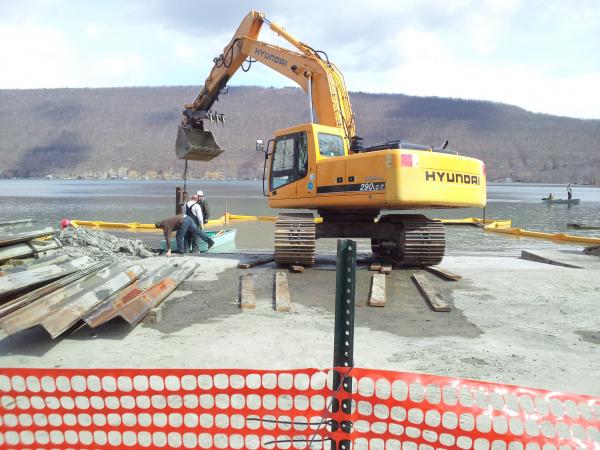 why can't they use the old docks? i launch out of woodville a lot and the docks seemed fine to me. I'm glad they extended the ramp, but what was wrong with the docks? dre marquis
 -
which fingerlakes will be involved with the salvation army derby?
-
Hi all, Last march i purchased Carlisle F78-14ST tires for my 19' Crestliner. They are load range C (up to 1760#). With my kicker, 2 batteries, trolling motor and other gear, i'm sure i'm either pushing or exceeding the load range and my tires show it - major cupping on the insides, and my trailer is in excellent condition (i measured from the tongue to the center of each hub and and difference was 1/8"). my question is what tires have you had good experience with? (i'm quite sure my next set will be load range D, but i have not been able to locate any 14" tires that are D rated). i may be able to switch to 15" tires but i'm not sure. thanks, andre
-
i am excited about the National Lake Trout Derby, but would also love to fish the Red Cross Derby again. Does anyone know if it will be held this year? andre
-
thanks for the input. does Hank work at Port Bay Marina and Campground? (that's all i could find on the web) can anyone give me his phone# thanks, andre
-
I need some work done on my yamaha. Can you recommend a mechanic who is competent with yamaha 4 strokes? thanks, andre
-
I need some work done on my yamaha. Can you recommend a mechanic who is competent with yamaha 4 strokes? thanks, andre
-
Canandaigua woodville lauch update
dremarquis replied to dremarquis's topic in Finger Lakes Discussion
it needs a dredging for sure - i ruined a prop last summer going about 2 mph - hit a pile of rocks