

iiwhistlerii
-
Posts
404 -
Joined
-
Last visited
Content Type
Profiles
Forums
Events
Gallery
Store
Posts posted by iiwhistlerii
-
-
3 minutes ago, LongLine said:
Yes, the water is high. The Ottawa average was 2" higher than last year. Can we get past that now? (even though that's nothing compared to over 30" higher on Big-O)
Some people want to believe tabloid clippings while others prefer reputable data/measurements. As we know which camp 2014er's are in and which I'm in, here's one of your tabloid articles from the Bay of Quinte that's kind of interesting especially what a past member of the St law' Riv' Control board says about 2014. (2014 is biased, etc....)
www.inquinte.ca/story/quinte-residents-rally-against-ijc-plan-2014
Here's a blurb from the USDOT submitted by the SLSDC:
www.transportation.gov/transition/slsdc-top-policy-issues
" Since the IJC's December 2016 announcement of the approved Plan 2014, environmental groups and shipping industry representatives have expressed support for the new water regulation plan. The only group at this point that has expressed concerns or opposition to Plan 2014 are landowners on the south shore of Lake Ontario whose homes will likely be flooded as a result of the new plan.
SUBMITTED BY: Saint Lawrence Seaway Development Corporation
LAST UPDATED: January 6, 2017"IJC knew there was going to be flooding and did nothing about it as their plan caused the expanded flood plain by not handling the inflow as historically would have been.
As has been mentioned many times before: why no answer to Gambler's question? (obviously due to the higher trigger levels of 2014. '58 would have opened those gates wider a lot earlier.) What is the pro-2014er answer to the question? (They beg that question an awful lot)
IJC claimed they were changing the plan due to environmental concerns as pro2014r's have also claimed. Here's their fact sheet:
https://legacyfiles.ijc.org/tinymce/uploaded/LOSLR/Plan2014FactSheet_EN.pdf
Yet they are now being sued by the NYSDEC for damage to the Riparian area above & below the dam and around the lake. The IJC misled a lot of people with mis-information just as the 2014er's are trying to do now in justifying their brainchild.
Someone once said that you can't convince someone that their position is flawed, even with mounds of reputable data because they emotionally own that position for whatever reason. So with that in mind, iiW' , even though you've posted a lot of untruths, I sincerely wish you a Merry Christmas and Happy New Year, hopefully it won't be underwater.
Tom B.
(LongLine)
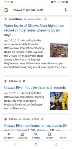
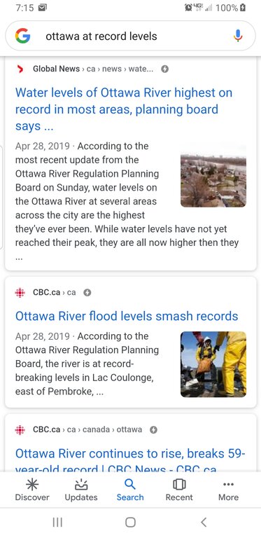
Tom I'm not sure what planet you are even on anymore. 2"? What on avg for the year? It's a river that rapidly rises and falls. When it's high it's high and then it drops. Water lines on the Ottawa were 9 foot over normal in spots. Litterally water to 2nd story roofs in spots. Please take the time to look at images and read the news from the past 6 months before responding. This is getting old.
-
Tom I really wish I could ignore facts and what is going on around the rest of the great lakes as well as you can. Ottawa broke records for flow, flood level and length of time above flood stage this year. Multiple times actually and in ever area of the river. Especially below the carillion dam. Keep ignoring the things that contradict your argument tho that's fine.
-
You cant because it's never been this high. Thus record. Same with lake Erie residents, also at record. Same with huron and michigan, same with st. Clair, same with the Ottawa. You seeing a trend here?? All at record levels. Plan 2014 isnt to fault here is my point. Natural levels would be much higher and levels with the previous practices would be exactly the same as what they are now. 2014s new parameters and practices havent even come into play yet and we are chopping off peoples heads without actually doing the research and making the comparisons that would actually assign proper blame. I dont know these people, if I had taken all this time to read what I've read and see what I've seen and thought for 1 second I could blame it on someone controlling a flood gate I would put the blame squarely where it belonged. It's just not the case.Maybe not in the IJC. A ship’ s pilot perhaps ? You obviously have an interest in keeping the water level at P-2014 levels. I don’t have all the graphs and charts that you present. What I do have is 70 years of experience on LO. My family owned a camp on N Sandy Pond through the 50’s and early 60’s down the road from the Wigwam. I have been on the S Pond for over 20 years In all those years , I can never remember water levels this high. You can spout all the reasons that the level is good. But I suggest you don’t do it face to face with a camp owner standing in knee deep water in his bedroom the property owners have got to band together and start a class action lawsuit against the IJC and P-2014. The threat of losing money is the only thing that will stop the Seaway and ship owners
Sent from my SM-G965U using Tapatalk
-
1 hour ago, chinook35 said:
Are you a member of the IJC ?
Sent from my iPhone using Lake Ontario United mobile appLol. Nope. Avid fisherman who's spends about 120 days a year on the water here on the great lakes. I spend my days from lake st. Clair, Lake Erie, Georgian bay, Niagara River, lake ontario, The st Lawrence and the Ottawa. It opens your eyes to what is really happening when you get to see it from all angles. I spent almost 40 days below that dam this season between july and Nov. I've spent a lot of time between massena and Montreal in the last 10 years. Its pretty obvious to anybody who's been down there that flow is increased and water has been higher for the last 3 years. With all that being said I live in Niagara county and I can hear the waves of lake Ontario from my back porch. When you observe it from all angles and do the research it changes your opinion on the situation.
-
Spot on comparison. A bunch of people ignoring facts hoping to effect regulation on fear based bs and not actual circumstance. Sad.Time to unfollow this topic. It's as bad as listening to someone who believes that gun control will stop gun crime
Sent from my SM-G965U using Tapatalk
-
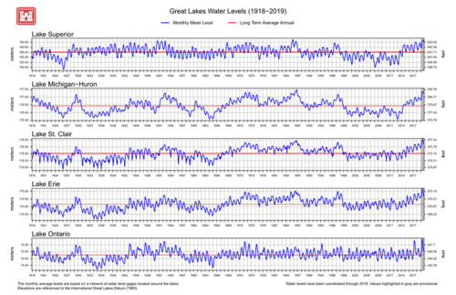
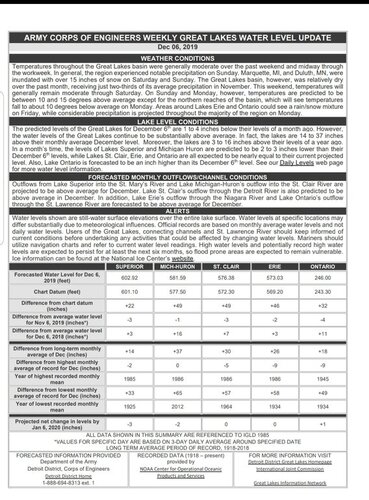
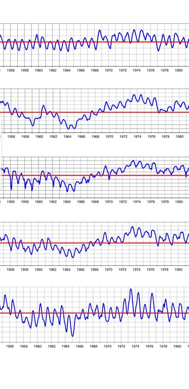
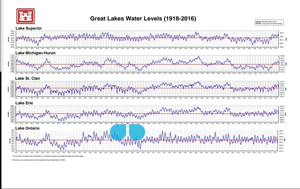
Let me know where on any graphs you see all time record highs on all the great lakes above lake Ontario and an all time record high on the Ottawa (that shares much of the same weather that affects our drainage basin) at the same time... oh yea, you wont, because this set of circumstances is unprecedented. 2014 doesnt just allow for higher highs. It also allows for lower winter lows. That seems to be the part everyone wants to ignore.iiW - OMG listen to yourself. Of course water levels are cyclical! Look at the Army Corps graph you posted, which supporters of P-2014 refuse to do. They show great variation, on the high side in the last 50 years EXCEPT Ontario which shows much less variation over that same period. (except '00-'12 for all the lakes) WHY? Because the Seaway water control was doing a pretty good job! It effectively got rid of the water in Ontario!
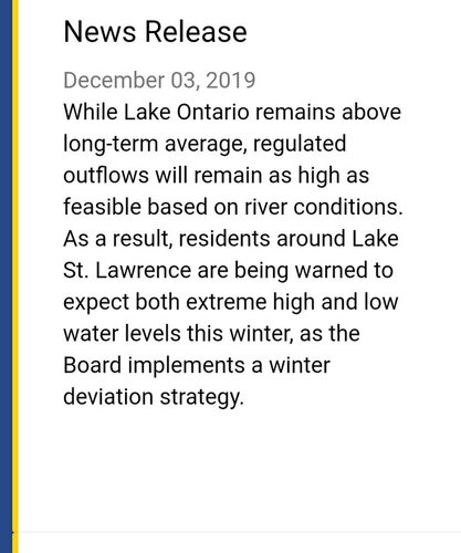
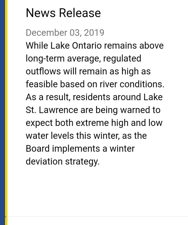
When the Seaway was constructed, the water control plan reduced the flood plain of Lake Ontario. (and did it for over 50 years) D-2014 allows that flood plain to increase as it is not getting rid of the water via higher trigger points. The IJC could have gotten rid of the water but it didn't as outflows were not increased soon enough and not kept going long enough.
Yes, they don't open the gates full from the end of Dec onward, but they should have and could have from Sept thru early Dec but they DIDN"T.
Up til the 1st of the year, shipping has everything to do with it. There's still a lot of ships out there and they have to move, which is the IJC's #1 priority. It was proposed at the early Nov IJC meeting that shipping should be suspended for the rest of the year but was shot down.
Sent from my SM-G965U using Tapatalk
-
11 minutes ago, HB2 said:Yea, but we can control it somewhat
When they closed the gates in Dec the first year in anticipation of it passing , the problems in LO started . I watched the water come up .
Suspend shipping now and open the gates to MAX . If they are serious about fixing the problem . ESPECIALLY with high water that cannot be controlled upstream .
Omg it has nothing to so with shipping this time of year. They need high water levels for the ships down below. Winter water levels are for safe ice formation on the river itself. They never "close the gates", normal power production allows for a natural flow through the river. Using the spillway to increase flow has to be done responsibly just as it has been for over 50 years.
When we keep putting up unreasonable solutions with faulty logic and poor understanding of the overall system we look like idiots as lake Ontario residents. You watched the water come up just as Lake Erie watched thier water come up and residents of ever great lake watched the water come up. It's a 300,000 mile drainage basin. Precipitation is to blame.
Sent from my SM-G965U using Tapatalk
-
Feel free to use that logic to explain the same high water levels on every other great lake. Apparently anyone with an IQ of more than 6.5 should know environmental factors can't cause this.[emoji849] Feel free to explain that to those living along lake Erie, Superior, Huron, Michagan and St. Clair who don't have anybody to throw blame at but mother nature.The sky isn't falling but the shoreline sure is washing away and a whole lot of people are getting flooded out .
And it sure is hard to run a business on the water for some .
Conspiracy ? We were told this was for environmental reasons and anyone with an IQ of more than 6 1/2 knows better .
Sent from my SM-G965U using Tapatalk
-
Exactly. It's all a cycle. We've been here before experiencing the highs and in a few years we will be griping about the lows. I just hope everyone redesigning docks and launches are keeping that in mind this time. It gets old listening to chicken little in panic mode all the time. The sky isnt falling.Not that many years ago water levels on Lake Huron and Georgian Bay were so low that peoples docks and boathouses were many yards from the shoreline. It wasn't that many years ago scientists were predicting a coming ice age. I don't want to play poker with mother nature I wouldn't stand a chance. The farmer wants rain, the golfer wants sun, the sailor wants wind, I want a light breeze how does she decide who to please and who to disappoint. I'm just thankful for any day I can stand upright and roll with the punches.
Sent from my SM-G965U using Tapatalk
-
These statements arent fiction. I'm not sure why everyone feels this is a conspiracy. None of this currently effecting shipping. That argument doesnt even come into play in this situation. They been dumping water as fast as safely possible since last winter. I can attest to this as I spend much of my time fishing the area around cornwall island and lake st. Francis. Water levels there have been kept much higher in the fall the last 3 years than they were in the previous 10. Everything effects water levels down below, wind, rain, outflows. It's very temperamental and water release is constantly monitored and adjusted to try and maintain a stable level and not wipe out entire islands on st. Francis or areas of montreal.
-
The example of an event caused my mother nature is right there in front of us. All of the great lakes are dealing with this, some worse!. What better example do we need as proof that mother nature is causing it?
Also again, flows are currently at safe maximums until ice forms and solidifies. Ice up below cornwall isnt far off. This is common practice to keep water levels below the dam steady during ice formation for safety. It's nothing new and has nothing to do with plan 2014
Sent from my SM-G965U using Tapatalk -
We dont control lake levels on the upper great lakes, mother nature does. So how do we prevent lake shore flooding there? We rely on mother nature and adapt. There is no "plug" here on lake Ontario. We modified our outflow in a way that is far from natural. We dredged shallow areas of shallow Rapids to create the seaway and dammed up and created slow moving lakes/reservoirs out of what once was a wild flowing river. Currently we let out as much water as possible without negatively affecting those who live along the "drain" below the dam. Right now the "plug" is pulled. Water is being let out at a natural rate, it's always being let out at atleast a natural rate. Plan 2014 actually allows us to let out more during the winter months than the previous plans did if you take the time to actually read how the changes work. It allows for lower lows each winter here on lake Ontario to keep the area below the dam higher because traditionally we've let the lower st Lawrence drop so low in the fall they cant even use thier boat launches to get thier boats out by November. With current water levels plan 2014 doesnt really matter, its parameters are out the window and they just scramble to let out additions water whenever they can. Everyone wants the spillway open earlier, or maximum flows year round like they did theoughout the summer to occur at other times of the year but it's just not possible without negatively impacting others far worse than the negative impacts we are experiencing here. You cant just let everything loose in march when half the river is still ice covered down below or when flows on the Ottawa are at peak levels. The impact down there is far greater than people realize. Water levels can and do rise 10+ feet and if we were to increase flows as the ice let's loose the ice jam flooding could be catastrophic to those areas. People keep complaining we didnt do enough all summer but none of them actually have spent anytime fishing below the dam and seen that water levels have actually been way up over where they traditionally have been for 3 solid years.
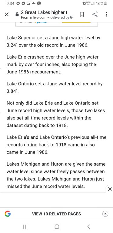
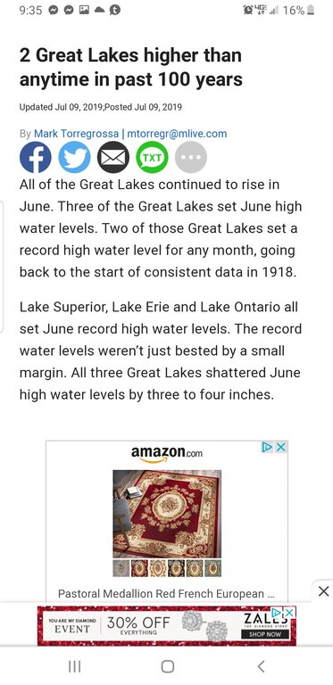
Basically it all comes down to one thing. When every single great lake and water shed in the north east is at record water levels we are foolish to believe that lake ontario should not be at record levels. It's like believing ur neighbor to the north got a foot of snow, the one to the south got a foot of snow but you should be able to see ur grass still. It just doesnt work that way. If everything both above and below is higher than ever, guess what, so are we. What can we do at this point? Pray for a dry spring and a little reprieve from mother nature and keep in mind it's not just lake ontario fighting this battle and we arent even the ones being effected the most by the situation. Id love to be able to jump on the boat with everyone else and impulsively blame the IJC and plan 2014 but when I sat down and read everything and then took the time to analyze all the available data and compare it to the years past it really is the only logical conclusion. The implementation of plan 2014 in 2017 and the fact that in coincided with record lake levels is nothing more than coincidence.
-
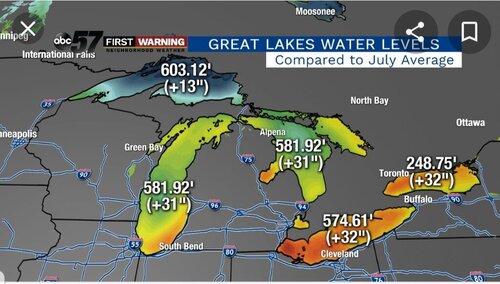
Record levels.... Just about everywhere.
-
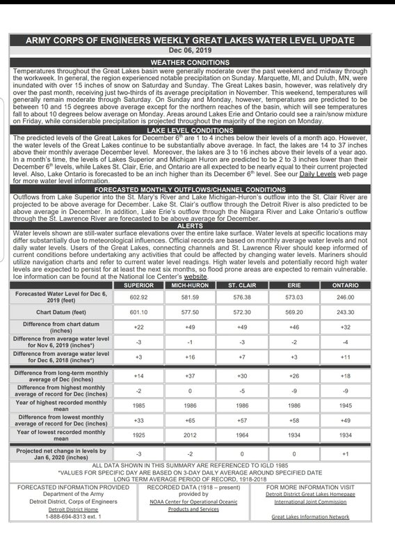
I'm not sure what I'm even arguing here. 66 and 67? Not even close to previous records. The all time record high for 3 out of 5 great lakes is 2019 and most of them set all time monthly highs throughout the year as well. The data is available and clear and many many articles have been published on that data. I've posted the graphs you referred to as reference. 2019 smashed all time records. Instead of comparing 2018 to current lake levels let's compare the long term average... superior +14, michigan/huron +37, st. Clair +30, erie +36 and ontario is at +18. Every one of these lakes dealt with the same problems we did all summer long, somebody them higher water levels, greater populated areas, bigger cities, more damage and for a longer period of time. You know who they have to blame, mother nature. The ships you keep referring to are running from the ocean to Montreal. You think they are holding water back now to make sure they can make it to Montreal? I just dont understand the current thought process. I understand plan 2014 will in fact let out more water and allow our winter levels to go lower in order to keep that portion high enough for those ships when needed but none of that comes into play with the conditions the past 3 years. Those ships are from Port of Montreal to the ocean only. Theyd never make it through the seaway any further. I keep presenting factual data with references to back it up and you keep telling me it's wrong without any facts. It's a very confusing argument.
-
-
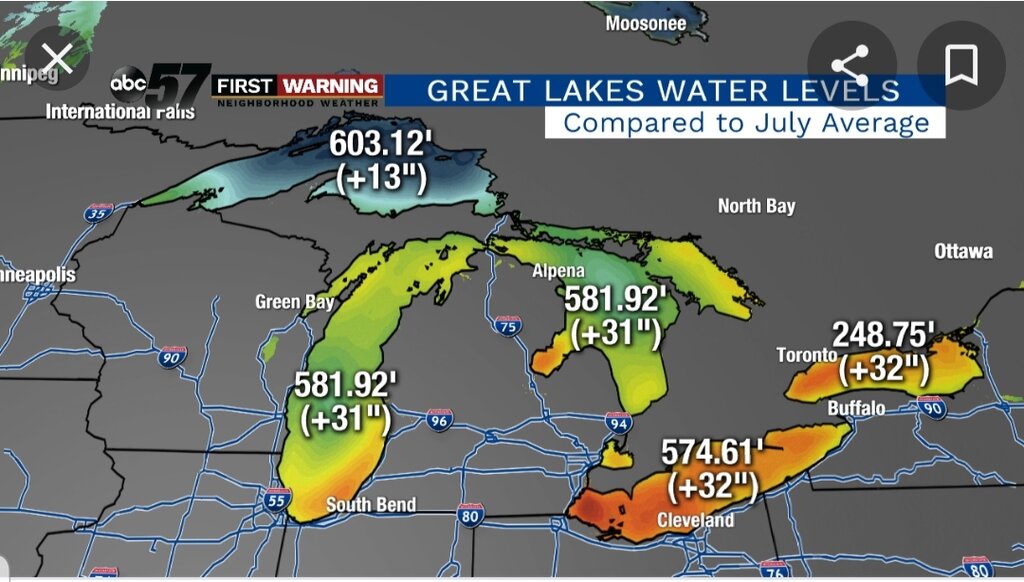
You can see here where we are today compared to the other great lakes. Lake ontario has actually faired better than the rest since July thanks to the water that was let go over the long sault all summer. Everyone needs to remember that theres nothing natural about the "drainage" that occurs as water leaves lake ontario through the st. Lawrence anymore. We created multiple reservoirs out of the river when we dammed it up and dregged massive areas that were once shallow rapids allowing more water to flow through those areas if left unchecked. Theres nothing "natural" about just letting the water go now. We have to regulate it to keep tolerable levels both above and below the dams.
-
Frogger look at the lake levels of the other great lakes from this summer. We werent even the highest over normal. Right now we here on lake ontario are one of the lowest over normal. Everyone has been feeling this since 2017. For some the impact has actually been much much worse.
-
15 minutes ago, Todd in NY said:
What makes you right, and everyone else wrong? Maybe it's you who is wearing the tin foil hat.
An adult discussion can & should take place without pounding your chest and bashing other members.
Todd in everyone of my posts I've stated facts and every rebuttal has been to tell me my facts are wrong. I stated lakes had all reached record highs, I was told I was wrong, I stated current water temps and actual reasoning for keeping steady water levels in the lower st. Lawrence this time of year, again was told I was wrong. I was even told I was wrong about the shipping channel depth above Montreal. Facts stacked on facts to help explain why things are done the way they are and why none of it has anything to do with plan 2014 because we havent reached scenarios where its parameters even come in to play yet. All I get is an argument about ships coming into port of Montreal which have nothing to do with any of this. I get that everyone is upset with the current water levels but everyone is dealing with them from Superior to Quebec city. In the end we've spent 100 years armoring shorelines and destroying an ecosystem. I understand the lake ontario stocked fishery thrives as we dump them in by the millions but the native fisheries that truly depend on natural spawning grounds and back bays on the st. Lawrence can only be helped by this experience. We are experiencing natural high water just like everyone around us, the nutrients being washed into the lake will help baitfish to theive. New spawning grounds will be created as a result of shorline changes and backwater bays being flushed and brought back to life are all something we should be happy about as outdoorsman. You can only put walls around the lake and treat it like a swimming pool for so long because eventually all you'll have left is an empty lifeless swimming pool.
-
 1
1
-
 1
1
-
-
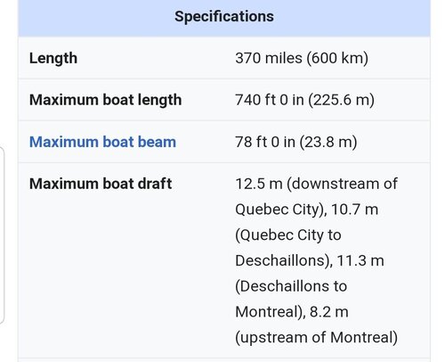
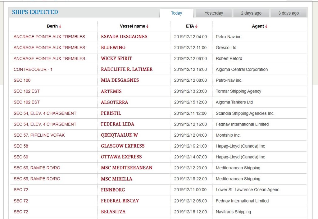
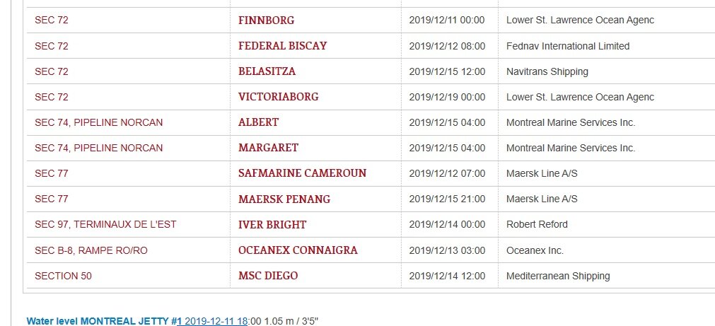
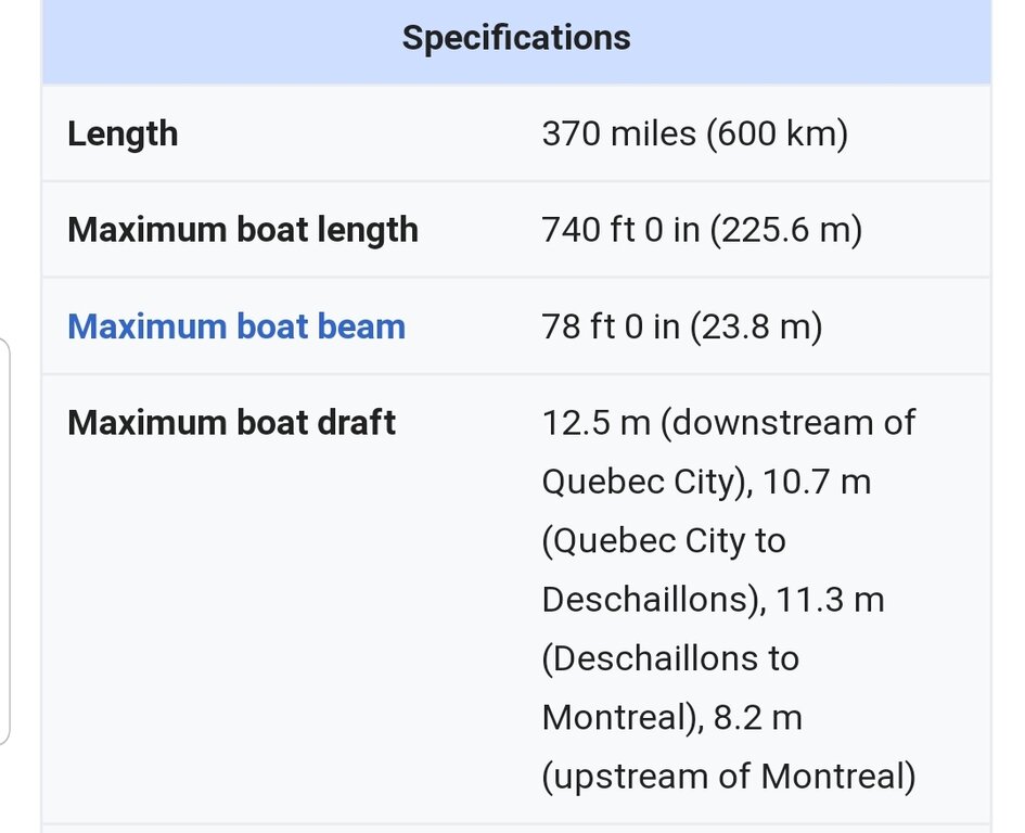
8.2 m above Montreal. Like I said, I've observed 27ft in the channel. Those ships will never come above Montreal without dredging and plan 2014 hasnt even come into play yet with these water levels. Take off the tinfoil hat and look at facts.
-
13 hours ago, LongLine said:
No you're right the world doesn't revolve around Lake Ontario, however you're forgetting that the purpose of the US/Canada treaty of 1909 that formed the IJC is to protect shipping on the Great lakes, particularly thru the St Lawrence Seaway. Now if sections are frozen or nearly as shallow as you claim then the these ships won't keep their scheduled arrivals in Montreal as the port expects them:
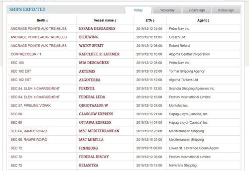
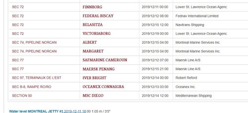
Especially the one whose last port was in Spain or the one from Portugal or the one whose last stop was Tangier. I'm sure that Maersk won't appreciate their bigger ships being stranded in ice and unable to get back out to the open ocean. Especially those over 35,000 tonnes, whose draft is well over 30 ft. (keyword: "Port of Montreal" then follow the left hand column headings & tabs)
The IJC & the plan supporters forgot that the world, for those people living around it & using it, is Lake Ontario. The current water plan was designed to help shippers, not the environment and certainly not the people BOTH around the lake and along (both up and down) the St Lawrence.
J2 - yes, and additionally, moving water requires much colder temperatures to freeze than standing water which is why a waterfall freezes AFTER the pond it feeds freezes. However Lake Ontario is not a small pond. Ice forms on Big-O at the shoreline first due to wave spray then builds outward due to the spraying effect. It's very rare for it to freeze over and when it has, it's been due to an extended calm period and a very prolonged deep freezing air temp. Most people think Big-O evenly streatifies, but it doesn't. The layers are very jagged i.e ups & downs like a mountain range.
-
11 minutes ago, LongLine said:
On 12/7/19 the outflow was 8,830 m3/sec. Except for 3 days in Oct, this is the lowest it's been since 5/31/19. In June, July & Aug it was over 10,000. according to the IJC water level site:
https://ijc.org/en/loslrb/watershed/outflow-changes (scroll down for previous years)
According to the GLFC water temp site: There is currently a very small pocket of water south of St Vincent being shown in the low 40's, however the deep section of the lake north of Sodus is in the 50's. (Yellow green) Normally this time of year the section off Sodus is in the very low 40's. The water currents map is also showing a strong twin gyre movement of water so IMO, it's going to be a while before we see substantial ice forming due to water temps.
There are "Panamax", Post-Panamax", "Panamax Plus" and a "New-Panamax" style container ships. The "Post-Panamax" which they celebrated in Montreal only requires 11-13 m or 36-43 ft of draft. The "New Panamax" is the one that requires the 50 ft range draft and they haven't come in...yet. (that I know of. I believe it's a length issue)
Tom B.
(LongLine)
Tom once again you're forgetting that the whole world doesnt revolve around lake Ontario. Water temps at Montreal are 36. Water temperatures directly below the long sault dam spillway in pollys bay and the area above Hawkins point are only 34. Harbors and bays froze up on both the upper and lower st. Lawrence days ago and that area below the long sault dam will be solid very soon. When the flows are up for summer and over 10,000 they are letting water spill over the spillway on the long saulte dam. This time of year the area above Hawkins point is a bay of trapped water sitting below the long sault dam as they dont let water rage over the spillway this late in the season. All the water being let through at this time of year will come through the moses Saunders dam below Hawkins point. In the summer the water level in that area can fluctuate 6+ feet in an average day and sometimes even more. It's very much like the area occupied by our power plants in the Lower Niagara. Allowing the water to fluctuate down there that much daily creates horribly dangerous conditions with ice this time of year. Thus winter water levels coming into play on Nov 1st and lasting until April 1st in these areas. Last I knew the shipping channel above port of Montreal is only 27ft deep in spots so unless they start dredging we never have to worry about seeing any type of panamax on lake ontario.
-
Tom B. With all due respect what reaction did you expect to take place in 2017 when the plan was in place less than 90 days and the lake level was preparing to reach all time highs just as areas of Montreal were being wiped out from floods on the Ottawa. Lake superior set monthly high records this year in May, June, July, August, September and missed october by 1.1 inches. The flood damage on every great lake is just as bad if not worse than we are dealing with here on Ontario. As somebody who regularly fishes Erie, St. Clair, the Niagara, Ontario and the St. Lawrence both above and below the dams and the Ottawa one thing I can tell you for sure is every one of them is experiencing the highest water levels they've ever dealt with. When you see water lines 9 ft above normal on boat launches and on 2nd story rooflines on the Ottawa you realize just how much water we have dealt with in the almost 300,000 miles that make up our drainage basin. Everywhere I've fished this year I've gotten to hear about how "it's the highest they've ever seen it in 50 years or 60 years of fishing there" but only here on lake ontario do we expect to be an exception because we have somebody to blame. We arent an exception here on Ontario because of some boards control over a spillway at a dam. 1 dry spring and itll be a non topic as everyone moves on to griping about how thier slip is bone dry and all the new poorly designed permanent docks are too high to use.
-
1
-
1
-
-
Huh? Lake Superior, Erie and Ontario all hit all time record highs this summer and Lake Michigan and huron weren't far away. Lake St. Clair also reached an all time high this summer. Since the summer high levels Lake Ontario has dropped more than any of the other lakes. Pay attention to the media all you like. My opinion on our situation is based 100% on research and fact and not just dock talk.
-
Ok. Now you do realize winter water levels on the lower portion of the st Lawrence exist for a reason right? It needs to freeze over at a certain level down there to prevent damage and once it does freeze over water levels need to remain stable. We are nowhere near plan 2014s winter lows and are letting out as much as possible to get there without causing damage down below. Plan 2014s winter levels havent even come into play yet. Hell the plan went into effect in Jan of 2017 and without any real changes we were facing record lake levels by April of that year. That's mother nature's fault plain and simple. Its not as simple as just opening the spillway over the long saulte dam all winter. Lake Ontario is right in line with all the other great lakes right now as it should be. When every major body of water surrounding us is at record levels, we will be at record levels no matter what plan is in effect. Seems pretty logical. The problem is while all the other great lakes are dealing with the exact same issue we here on lake Ontario feel we have somebody we can blame. In 5 years we will all be complaining about the water being 5 feet low and them letting too much out. Just hope your marina was smart enough to install floating docks this time.

Is there hope ?
in Open Lake Discussion
Posted
I love it. The Ottawa was so high it was at risk of dam failure most of the spring and did have levy failures in multiple places and somehow you manage to dumb that down to 2". Sad. You gripe about the 30" high that we were. Well guess what, we are down to 18" over average thanks to the increased flows. You know who's still 30+" over average? Erie, St. Clair, Michigan and Huron. All lakes who's water levels are left to mother nature to decide. Crazy!! How could natural lakes be that high from just weather!? Good chance theyll all be higher over long term avg than ontario is again this year.