

goin hungry
-
Posts
160 -
Joined
-
Last visited
Content Type
Profiles
Forums
Events
Gallery
Store
Everything posted by goin hungry
-
Cayuga New to trolling, no luck yet on Catuga. Any help?
goin hungry replied to sstout's topic in Finger Lakes Discussion
 Also, turn often. This allows you to see if they hit on the outside (faster lure speed) or inside of the turn (slower lure speed) then adjust accordingly. Sent from my E6782 using Lake Ontario United mobile app
 -
Cayuga New to trolling, no luck yet on Catuga. Any help?
goin hungry replied to sstout's topic in Finger Lakes Discussion
Also, don't know if you're talking about speed at the surface or the ball, but these speeds should be at the ball. Down speed probe is vital.With the current in these finger lakes you can be doing 3mph on surface but closer to 1 at the ball. Mix up your trolling directions too. Some days we kill em going one way and nothing the other. They must face upstream Sent from my E6782 using Lake Ontario United mobile app -
 Way to go. You are a true sportsman for releasing that beautiful fish and taking the effort that you did Sent from my E6782 using Lake Ontario United mobile app
 -
Agreed Sent from my E6782 using Lake Ontario United mobile app
-
 Good report! that laker looks like it has legs!! Seneca sea monster? [emoji15] Sent from my E6782 using Lake Ontario United mobile app
 -
 Way to get into the fish and get the kids involved! That ff screen is so good it looks like it's set on simulation mode! [emoji2] Sent from my E6782 using Lake Ontario United mobile app
 -
Navionics+ card on Humminbird Units
goin hungry replied to goin hungry's topic in Finger Lakes Discussion
 I'm no expert and haven't seen the garmins in action, but from what I understand they may in fact come pre loaded with some better maps without buying a separate card. For my unit it came with basic nav maps, but I had to buy a separate navionics+ card to get the ability to have more detailed maps. Even then, those maps weren't completely accurate, but they update to accurate 1ft contours as I record and update my sonar logs. More expensive units can update automatically right in the boat as you're trolling, but those units weren't out yet when I bought mine. If you don't use side scan or down imaging, then yes, if recommend that you get a good quality down sonar (I haven't seen but heard the Chirp sonar available on many models now is latest new technology and is good) and get one that has ability to either have contour maps downloaded or updated. As I said with my unit, even tho the nav program that I purchased came with 1 ft contours for some lakes, they weren't entirely accurate. With update ability you can get it exact, which is important for many lakes like the finger lakes where you can have very steep and abrupt drop offs and rises. Now that I have my Seneca maps updated current and exact, when I come up on sharp rises and points, I don't drag my balls through the mud anymore! (Unless I want to) Sent from my E6782 using Lake Ontario United mobile app
 -
Questioning Navionics accuracy for small lakes
goin hungry replied to muskiedreams's topic in Finger Lakes Discussion
Right - using Sat signal I think? The other option involved instant update to your smartphone or mobile device from a ff that is wifi or Bluetooth enabled - as your sonar reads bottom it will transmit directly to your handheld and update the maps in real time. I've never used or seen either in action, just what I've seen on the web Sent from my E6782 using Lake Ontario United mobile app -
Questioning Navionics accuracy for small lakes
goin hungry replied to muskiedreams's topic in Finger Lakes Discussion
Keuka - I do like my unit and the navionics program, but it all could be much more user friendly. Yes, if you Save and upload your own sonar logs you will get the 1 ft contours for that area that will be visible in your ff unit after you upload the data to navionics and then reinstall your card in the ff the next trip. This should then also then update to the "community" - meaning that others that update their cards should get the benefit of your uploads too, but I'm surprised that there isn't better info for the finger lakes given how many guys fish it, but maybe not enough techies are uploading their data... If you have a sonar unit with wifi like the helix then your charts automatically update while you're driving I have been told. Looks pretty cool if you check it out on navionics website. Sent from my E6782 using Lake Ontario United mobile app -
Navionics+ card on Humminbird Units
goin hungry replied to goin hungry's topic in Finger Lakes Discussion
PM sent Sent from my E6782 using Lake Ontario United mobile app -
Navionics+ card on Humminbird Units
goin hungry replied to goin hungry's topic in Finger Lakes Discussion
That's true - you definitely want to ensure that it's compatible with your unit, tho from what I've seen, these cards are widely comparable with most units. Even if it is, however, you might not get all "features" that are available, so just be aware of that. For instance, on my Humminbird 9 series, I can update my sonar logs just fine, but there is another feature for points of interest that the community can also add to, and my unit isn't compatible with that feature. That said, I wouldn't want it anyway, because I want my own points of interest without clutter from everyone else. Frogger, of you're interested I can PM you where I recently bought my card. Sent from my E6782 using Lake Ontario United mobile app -
Questioning Navionics accuracy for small lakes
goin hungry replied to muskiedreams's topic in Finger Lakes Discussion
While it's true that sometimes you get basic maps, if you record and update your sonar logs you'll get the detailed contours on any body of water. Sent from my E6782 using Lake Ontario United mobile app -
Questioning Navionics accuracy for small lakes
goin hungry replied to muskiedreams's topic in Finger Lakes Discussion
If you update then everyone else should be able to see it, like Swarthout point as mentioned above. Once you get the hang of it it takes 5 seconds to start a sonar log recording, then you just stop and restart a new one every half hour or hour or so and it doesn't impact fishing at all, provided you have your ping rate set to high or auto, as I mentioned in my previous post. Seeing to one ping per second as navionics recommends will render your sonar useless Sent from my E6782 using Lake Ontario United mobile app -
Questioning Navionics accuracy for small lakes
goin hungry replied to muskiedreams's topic in Finger Lakes Discussion
My understanding is that there is currently a WiFi enabled app that you can instantly link to navionics that will allow your maps to update I do agree that it is a bit of a hassle and that not many guys seem to be uploading their sonar logs, but I recorded and update every time I go and hopefully everyone can benefit from that new detailed knowledge. Might be worthy of a test try - maybe you screen shot the maps that come with the program, then scan and upload your Waneta or lamoka maps and see if they show the updates on other guy's maps. It should update for everyone if it's truly a "community" update. I only got the program a month ago and have been playing with it and figuring it out. Sent from my E6782 using Lake Ontario United mobile app -
Questioning Navionics accuracy for small lakes
goin hungry replied to muskiedreams's topic in Finger Lakes Discussion
I have navionics+ and also update to the community function every trip. Basically, those maps will get you started, but then you need to record and upload your specific sonar logs. Then the next time you go out you will have all accurate information. I was surprised myself to see that some areas that I know are heavily fished by serious guys doesn't have more information in their maps, but I think many guys don't take the time to record their loss and update their maps for the community. I can see why too - the instructions you get from navionics, and what's available on the web, really don't show all that you need to know and do to use the program and your sonar to it's fullest potential with the program and sonar that I have. Here is a link to a post that I recently did on the more advanced info that you need to know to make use of it on Humminbird, but I'm sure some of it carries over to other models too: http://www.lakeontariounited.com/fishing-hunting/index.php?/topic/57511-Navionics+-card-on-Humminbird-Units I know it seems like a lot and can be frustrating that you paid a pretty penny for technology that isn't quite there yet, but after you do update your maps with your logs it's worth it, and I know that the technology will only get better - like the way you're already able to update your maps instantly if you have WiFi capability through certain phones and sonars. Sent from my E6782 using Lake Ontario United mobile app -
Hey guys, I posted this in another section - thought it should go here too... http://www.lakeontariounited.com/fishing-hunting/index.php?/topic/57511-Navionics+-card-on-Humminbird-Units Sent from my E6782 using Lake Ontario United mobile app
-
 Awesome thanks! Yup, we love the small pink ones for bows on finger lakes Sent from my E6782 using Lake Ontario United mobile app
 -
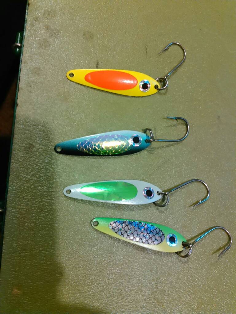
Sorry, autocorrect in the subject line - should read "name of these spoons" Sent from my E6782 using Lake Ontario United mobile app
-
Can somebody tell me the name of these spoons? We have always called em pinfish but we can't find any by that name anywhere and need to replace a couple that we've lost. Thanks! Sent from my E6782 using Lake Ontario United mobile app
-
 Gonorrhea Sent from my E6782 using Lake Ontario United mobile app
 -
-"High-Maintenance" (It reminds me of a girl I used to know...) -Gwen Stefani -candy froggy Sent from my E6782 using Lake Ontario United mobile app
-
 It's like I always say, those last 3" make all the difference
 -
 That's the simulation view screen! Lol
 -
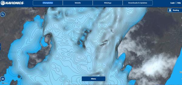
I have an 899 HD Di SI Humminbird Fishfinder and recently got the Navionics Plus chart card. In trying to set up and use the card I found that there is some information out there but not enough to really use it effectively so I thought I'd post here in case any guys are using the card and having the same troubles I encountered. I do find that it is a great tool for getting very accurate bottom readings because you can record your sonar on two logs, upload them to your laptop, and then in a day or two, you go back and Navionics will have updated the map for the area that you fished so you can update your card with that new very accurate information. This is particularly helpful in the Finger Lakes where you can have drastic depth changes in very little distance. If you go online you'll be able to find many tutorials on how to basically use the card, so this post is going to go a few steps beyond that. You'll want to find other tutorials as to how to configure your unit (such setting the unit menu to "advanced" and what not. The hummingbird website has a good step by step tutorial for that if you Google it). Ok, now on to the stuff I didn't know after buying the card and researching the instructions that came with it... First in order to get your Humminbird unit to even recognize the card you need to have it plugged into the unit properly and then you need to go on to your chart View menu tab and scroll down. If the card is properly inserted a menu item will pop up that says chart select, if that menu item is not found on the sonar charts screen, then the card has not been properly inserted. I know this sounds really simple, but I found myself struggling with it several times out on the water. What I have found is it's best to go to the charts menu, and then stick the card in, push it in until it clicks, and then you will see the menu add a selection for selecting the sonar chart. The next item I struggled with was getting Humminbird unit to actually read the card. In order to do this you need to select the sonar chart named "right side fish n chip". For whatever reason, even when the card is properly inserted the unit will not read it in the "auto" mode setting. Seems odd to me, but that's what it is. Next, and something that isn't very apparent when you first buy the navionics card at the store is that you need an additional SD memory card to actually record to. So you need 2 cards - the navionics card that you buy, as well as a blank SD card to record to that you have to purchase separately. The first time I was out on the lake I didn't have the second blank card, so it wouldn't record, and I spent 2 hours on phone with customer service while the other guys fished because the unit or the instructions really don't tell you this info! Try to get and use a card for this that is at least 8gb size, because every hour of recording is 1gb size, but it's nice to have the extra room in case you forget to clear your logs from the last trip. I use a 32gb card that I got at rite aid on sale for $15 down from $60 - they go on sale there if you keep an eye out. This blank card should be inserted into the left side slot on your unit, with the gold tabs of each card facing to the right. Ok, now you have both cards properly inserted you need to record your logs. This is an area that took me some time to get down, but with practice it only takes a few seconds. First, if you're on split screen mode (which you will be if you have sonar on one side and the map on the other side of your screen) be sure that the "active side" is set to your map side. This is done by hitting the menu button, and then you select between left or right. I find I'm constantly going back and forth between left and right as active during the day, so get proficient at it. Reason is, say you want to change your max bottom depth - then the sonar side needs to be active in order to get to the proper menu screen to change that. If the map side is the one that's active then you can't do that. The same thing goes for changing the map settings, if the "sonar" side is set to active, then you can't adjust your map settings. Next in order to do a recording log you have to get to the recording log screen. The online tutorials will show you how to get to the screen, but you will be constantly going back and forth in and out of that screen as you do your logs. Therefore I recommend that you set the recording screen as one of your One Tap menu buttons that way, you can push one button to quickly get to that screen to start a recording, and then hit another one touch button to return to your favorite sonar and mapping screen, without wasting much time cycling between views. Next, and this is VITAL - The tutorials tell you to set your recordings at one "ping" second. What they don't tell you however, is that by setting it at 1 ping per second, you will actually slow your chart speed way down to the point that your sonar almost becomes unusable because it doesn't read fast enough. It took us several trips of making no fish at all to realize this. So set your ping rate to a higher number, or to auto, which is what we use. This will ensure that your sonar still functions the way that you are used to seeing it run while you're recording. If you don't do this then you'll still get good logs, but your sonar will be useless for fishing the whole time you're out there... Next, I recommend that you start and stop recording logs every 30 mins or so. The reason for this is that sometimes you lose bottom, or the readings are kept properly, and when you upload them to hummingbird they will reject them. I generally take 20 or so recordings per trip. If we have rough water and I lose bottom, then a couple of those logs will be rejected. If I only did one recording all day instead of multiple recordings, then the whole thing would be rejected and that day's work lost. To stop recording just push menu button (with the map side active) and the first option still be to stop recording. Push the ride toggle button to select stop, then hit your one-touch button to return to the recording screen and quickly start another recording log. This will make your logs seamless. Then hit your other one-touch button to return to your sonar and chart View. If your unit is properly recording to your card there will be a red dot on the top of your screen and it will say "recording". Finally, when you're done fishing, you need to take BOTH cards out of your unit and home with you. You plug the navionics card into your computer and the app will start, then you swap out that card for the SD card that you recorded to, and the app with pop up with an "upload charts" option. Select that and your data will be uploaded. Once the data is uploaded, delete all the files from the SD card (NOT the navionics card- if you wipe that one you've just lost your mapping program). Now you wait. Navionics will send you an email that has a link to your uploads page. Bookmark this page or save the email - they don't email it to you again after the first time, so you'll need it for later uploads and downloads. After a couple days you go back to your uploads screen and it will tell you that your recording logs are either rejected (lost bottom, etc), still pending, or ready. If they're ready, then you insert your navionics card and then go back and re-download the area that you made logs of. This is what saves the new information to your navionics card, and then when you go back out all of that updated and detailed information is note at your fingertips on your unit. Remember to bring your navionics card and your blank SD card back to your boat, and then you start the process all over again for new recordings. Overall I do like the technology. However, I think it's a lot of work and rather cumbersome. They're coming out with a new mobil app as well as program that works instantly with the newer units that have wifi connectivity, that way as your trolling your charts automatically update - very cool stuff. I was also surprised that it appears not a lot of guys use the upload technology to make the program better. I thought the South end of Seneca would be all mapped and current by now, but it wasn't. That large hump just south west of the salt plant had claimed a few of my spoons and it was still not reflected very well on the existing charts. Well not any more - I've updated all my charts in that area so that anyone with the navionics program should now have accurate 1ft contour maps for that area.
-
Agreed. Used to be you'd find bait ball every 200 yards, especially on South end. Now we're lucky to mark one or two pods the down there all morning...