
bayofquintecharters
-
Posts
85 -
Joined
-
Last visited
Content Type
Profiles
Forums
Events
Gallery
Store
Everything posted by bayofquintecharters
-
X5 on the torpedo swivels. I've been using them for 4 years now and love them. I like the rounded end and the secure clasp. The only thing is they can be a little tricky to open. You'll get a technique where you open and twist in one motion. By the end of a season I have indents in most of my nails from opening them. Lol. Scott Sent from my iPhone using Tapatalk
-
 Interesting. There are definitely some Furuno units that support Navionics. There are some that do not. Anyway sounds like you got it sorted out. Scott Sent from my iPhone using Tapatalk
 -
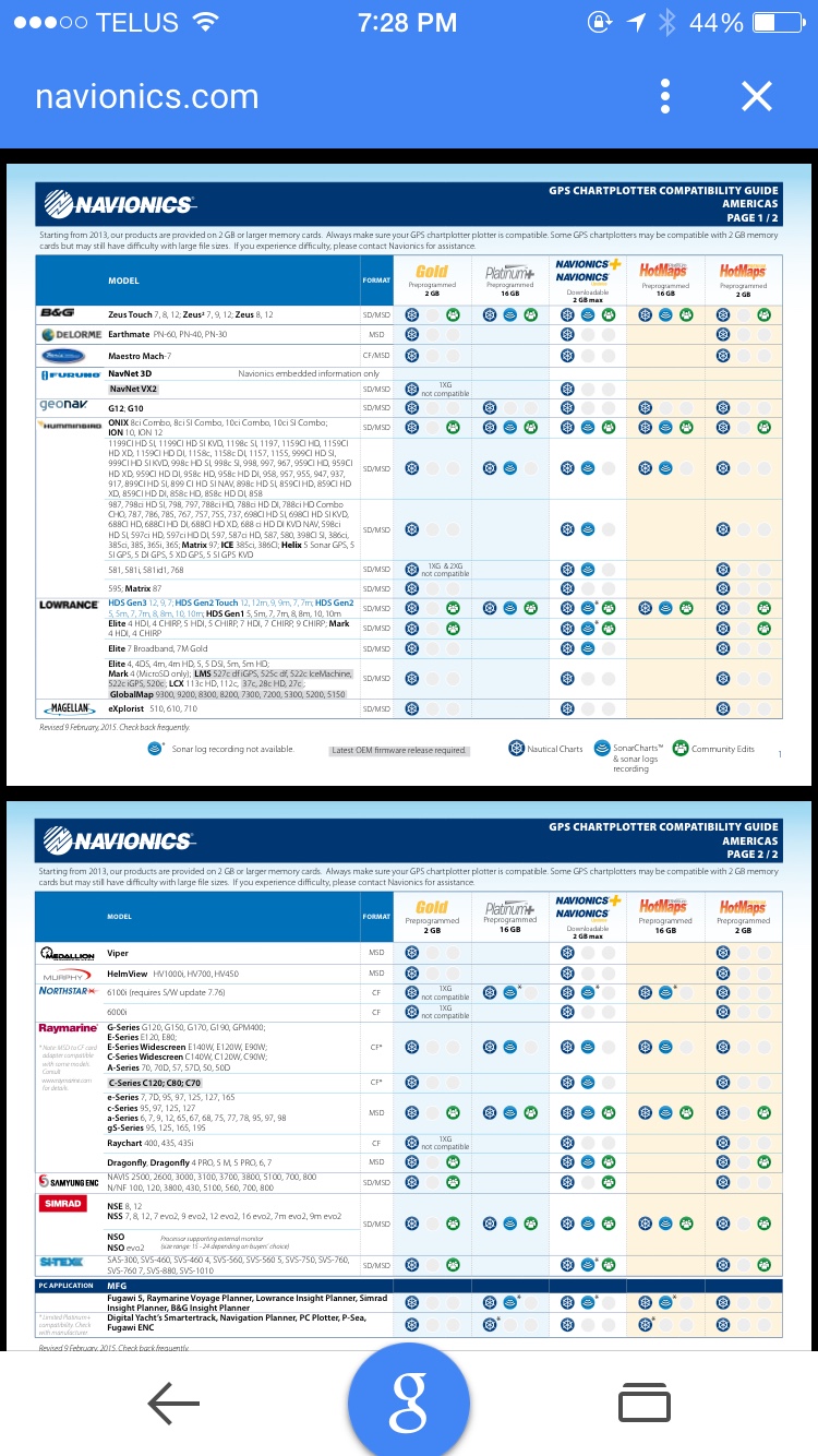
What model unit do you have? The Nav+ card which is available just about anywhere is compatible with certain Furuno units. Let me know what unit you have and I can confirm. Scott Sent from my iPhone using Tapatalk
-
I have run it both way in boats. In my experience it will work without an external antenna, although a lot depends on your specific boat. That being said, with the antenna you will lock into your position faster and have better reception on cloudy days etc. Sent from my iPhone using Tapatalk
-
 Sign up below for a 1 hr seminar on Chartplotter basics. I will start from the beginning with powering up a unit then move to making your chartplotter work for you by using split screens, setting up pages, shallow water shading, managing trails and tracks. I will be working with a Simrad NSS unit which has a very similar interface to the Lowrance units. Other manufacturers will be a little different but most have the same capabilities so you should pick up something useful. I will also touch on sonar basics, touching on different types of transducers, proper transducer installation, understanding how sonar works, cone angle calculations, and dead zones. I will also touch on Chirp technology and how it is different from traditional sonar. Please register for Chartplotter basics with tips and tricks on Apr 24, 2015 8:00 PM EDT at: https://attendee.gotowebinar.com/register/7477859210107914242 It is easy to be intimidated by modern chartplotters (gps/fish finder). Learn the basics of how your sonar works. Learn the basics of setting up your chartplotter from selecting and adjusting screen sizes, setting ping speed, scroll speed, how to select a map coverage area, and some more advanced map options. This seminar will appeal to the basic and intermediate boater. After registering, you will receive a confirmation email containing information about joining the webinar. Brought to you by GoToWebinar® Webinars Made Easy® Scott Walcott Navionics Marine Specialist Owner/Operator Bay of Quinte Charters
 -
Fishhawk and Lowrance transducers close to each other?
bayofquintecharters replied to codybuehler's topic in This Old Boat
 From Fishhawk's website. Scott Sent from my iPhone using Tapatalk
 -
Old sword found in Lake Ontario
bayofquintecharters replied to bayofquintecharters's topic in Open Lake Discussion
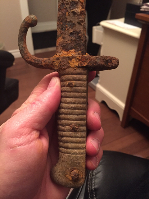 Wow. That was easy. Lol. It looks identical to that for sure. Wonder how the heck it got into Lake Ontario. Thank you very much Thun. How did you come across that page? Sent from my iPhone using Tapatalk
 -
I just came across an old sword that I found as a teen in Lake Ontario. I forgot I had it and just curious if anyone has any ideas of the date and authenticity of it. For all I know it may be a toy or replica that some threw in the lake. The handle seems to be solid brass so I don't think it was a toy. I know nothing about swords but thought someone may recognize the style and have an approximate age. Sent from my iPhone using Tapatalk
-
I wouldn't be without one. Sent from my iPhone using Tapatalk
-
The all stainless marine ones last a lot longer, but are about 3 times the price. Sent from my iPhone using Tapatalk
-
It isn't all about power. I agree a 600 watt is plenty but a thru hull transducer will have a cleaner clearer return compared to an in hull. It does boil down to what is "good enough" for you as the game of having the best never ends. As for drilling a thru hull. Although it is intimidating, it really isn't that bad just measure 5 or 6 times to make sure you aren't to close to stringers etc and drill her through. It is certainly doable. There are lots of videos to help you step by step. Scott Sent from my iPhone using Tapatalk
-
Great info on this thread. Just to throw my vote in the hat. I like the 19 strand torpedo wire. In fairness I haven't used a lot of other brands. I started with the 19 strand and it has always been good to me so I've stuck with it. Cool tip Yankee. Thank you for posting. Scott Sent from my iPhone using Tapatalk
-
Hey guys I did a webinar lastinght on charting your own lake and how to update your charts. I was supposed to record it and forgot to, so I have to run through it again and record it this time. It is tonight March 23 at 6 pm and wont be more then an hour. Probably just about 40 minutes and then you can ask some questions. Please register for Chart Your own Lake on Mar 23, 2015 6:00 PM EDT at: https://attendee.gotowebinar.com/register/5233163341139465473 Navionics SonarCharts gives users a dynamic community based layer that can be easily modified by submitting sonar logs. The new relationship between Navionics and Vexilar allows for SonarCharts live and the instantaneous creation of charts for uncharted waters or for increased accuracy and detail. After registering, you will receive a confirmation email containing information about joining the webinar. Brought to you by GoToWebinar® Webinars Made Easy® Scott
-
Garmin SonarCharts - Free beta cards available
bayofquintecharters replied to bayofquintecharters's topic in This Old Boat
Some of Garmin's maps are great some of them are not as good as the Navionics coverage. I have found the inland lakes are usually better with Navionics. I think the biggest advantage Navionics has is the ability to upload your sonar logs and regenerate the charts. The system is really slick and easy. It takes just minutes to upload your logs and the charts are updated with your data. It's very easy and efficient. The best thing to do is compare the two for your body of water. You can see exactly what the Navionics data will look like by going to the webapp and viewing your area. Just go to Navionics.com and click webapp on the top right. Zoom in on your lake and make sure to click the little blue sounder icon on the bottom right corner that turns on the SonarCharts data. Zoom in enough to see the detail and decide if you want it or not. That's the best advice I can give. As for the software update. Anything new that garmin puts out will not support the Navionics card. If you have a unit that supports it and you don't want to lose the ability to use the Navionics card then just don't do the software update. Scott Sent from my iPhone using Tapatalk -
Garmin SonarCharts - Free beta cards available
bayofquintecharters replied to bayofquintecharters's topic in This Old Boat
I just found out a whole spreadsheet of names that I submitted to receive cards didn't get them. I have resubmitted the spreadsheet that somehow went MIA so if you haven't received a card and you had submitted your name. My apologizes. It should be coming soon. Please don't be shy to shoot me off an email to follow up. The feedback I have received about the cards has been fairly positive. Here are some screen grabs from the 901 card that covers the great lakes. Scott -
Garmin SonarCharts - Free beta cards available
bayofquintecharters replied to bayofquintecharters's topic in This Old Boat
Sorry guys the beta program is now closed. To those that got a card let us know how it works and what the charts look like. Sent from my iPhone using Tapatalk -
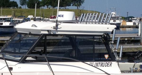 I have the NSS8's. Great units. Just take your time and do a good job with connections etc. Radar installation really matters to get good even returns. Do some research on how to properly mount the dome. Don't over stress about it. You can always correct it. You will LOVE radar overlay. Scott Sent from my iPhone using Tapatalk
 -
Under $500 would be lowrancs elite 5 HDI. If you're used to a lowrancs product you'll probably prefer a lowrancs product. Sent from my iPhone using Tapatalk
-
I know I posted this once already but wanted to post it again in case some Garmin chartplotter owners missed it. Navionics is releasing SonarCharts for Garmin and are willing to get beta cards out for free for some feedback. If you have a Garmin chartplotter please email at [email protected] with the following. Your name Mailing address Phone number Email address Chartplotter model. Scott Sent from my iPhone using Tapatalk
-
Garmin SonarCharts - Free beta cards available
bayofquintecharters replied to bayofquintecharters's topic in This Old Boat
Thank you to those that have emailed me. Still lots of cards available if you are interested in one email me. Scott Sent from my iPhone using Tapatalk -
Navionics will be releasing SonarCharts for Garmin early in 2015. This will be the same data that you see on SonarCharts layer on the webapp, the mobile app, and the fish n chip layer on chartplotters. Navionics would like to get cards into peoples hands to test them and to provide some feedback prior to the rlease. I can give 20 cards away per forum and I will be posting on several forums. If you run a Garmin chartplotter and would be willing to to provide a little feedback please email me at [email protected]. If you want to see what the data will look like go to http://webapp.navionics.com/?lang=en and zoom in on an area, click the little sounder icon in the bottom left to see the "SonarCharts" data that you will be getting. You will also be able to upload sonar logs to update and create charts. When you update your card at navionics.com you will have the charts you created on your chartplotter. I need the following info: What forum you read this on, your name, mailing address, phone number, email address, and plotter model. Scott
-
Quinte ?
bayofquintecharters replied to askMyWife's topic in Ontario, CA Fishing Reports - Lake Ontario (North Shore)
Big Mac is spot on. Exactly as he states. Scott Sent from my iPhone using Tapatalk -
For trolling I don't think you can beat the Garmin Tr 1 gold. I have the Simrad Ap 24 which is very similar to the new lowrance autopilot that is coming out. To get it to hold heading at low speeds you really need to add a rate compass. Most auto pilots will have trouble holding a heading at low speeds 3 mph +\- the TR 1 gold is designed to work at trolling speeds and is incredible. The new lowrance autopilot or the Simrad with a rate compass will work well to. But as Big Mac said you will be surprised how much you appreciate the throttle control on the Tr1. Speed is very very important to sucess somedays 0.1 of a mph will be the difference and getting that kind of control manually is very difficult. Scott Sent from my iPhone using Tapatalk
-
Navionics for your Windows PC or Tablet
bayofquintecharters replied to muskiedreams's topic in Open Lake Discussion
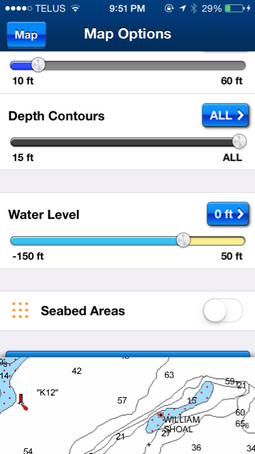 The $3.99 is for advanced map options. That gives the ability to shade different depths etc. There used to be separate $15 costs for the basic maps and nav+ that includes the sonar charts layer that increases the detail. Now you get nav+ with the basic $15 purchase. All the charts in the world are available to view for free at www.navionics.com. You just have to click the "webapp" at the top. The problem with these are that you have to have Internet access to view them. The new pc app will be the same as the ios and android apps. No data required to view and navigate with them once downloaded. Scott Sent from my iPhone using Tapatalk
 -
Navionics for your Windows PC or Tablet
bayofquintecharters replied to muskiedreams's topic in Open Lake Discussion
Excuse me for jumping in. The price for the platinum + would be for the card that goes in your chart plotter. The other prices quoted are the in app upgrades for the nav+ that gives you SonarCharts. What "app" do you have on your windows 7 PC? How long ago did you get it? The new app released that requires windows 8 is a similar app to what is currently available on android and iOS devices. This app has the Nav+ upgrade that gives you sonar charts and community edits. Scott Sent from my iPad using Lake Ontario United