

Lucky13
-
Posts
1,234 -
Joined
-
Last visited
Content Type
Profiles
Forums
Events
Gallery
Store
Everything posted by Lucky13
-
 Matt Sanderson has a new report on I-Bay out, a lot of detail on gamefish. I tried to attach it but I think it is too large, but you may be able to get a copy from Region 8 in Avon.
 -
Another 20% CUT in Chinook Stocking for 2019
Lucky13 replied to Tall Tails's topic in Open Lake Discussion
 Likely a very good question for a week from tonight, but I know the process in place for regulations changes is not rapid.
 -
Status of Seneca Lake DEC Meeting 10-2-18
Lucky13 replied to Sk8man's topic in Finger Lakes Discussion
 I will be sorry to miss this but it is a long drive home to Rochester in the dark.
 -
Another 20% CUT in Chinook Stocking for 2019
Lucky13 replied to Tall Tails's topic in Open Lake Discussion
"With stocking issues, the adult population is only going to drop more. If the levels drop below the target, don't be surprised if the lake trout stockings increase over kings." Let me see if I can get this straight. We have issues with stocking i.e. we are not getting enough little fish from the Feds to meet quotas, so the Lake trout adult population is declining, so we should expect to see more stocking. But we can’t get enough little lake trout now, what makes you think they will suddenly materialize because a “goal” changes? You should also remember that the consensus document, the Fish Community Objectives, contains the lake trout as the top BENTHIC predator, along with the King as the top PELAGIC predator, so it is unrealistic to expect the lake trout to get phased out in favor of more and more kings. Also, Lake Ontario is governed by more entities than the State of New York, both the United States and Canadian Federal entities have jurisdiction, as well as the Province of Ontario, and native species restoration is a priority at the Federal level because the thought is that it is not possible to make the judgement that the resource, Lake Ontario, has recovered from the multiple stressors to which it has been subjected over the last 100+ years if the native flora and fauna are not present, and at least on the road to recovery. So Lake Trout are a priority and indicator for the Lake Ontario Action and Management Plan (LAMP), and will continue to be “pushed” by the Federal entities. I know that DEC management follows these conversations, so I would expect that we will see a detailed table of what is expected to be stocked in 2019 under this scenario, and I have been told that the 20% cut still occurs to Lake Trout. Finally, I get this sense that at least part of the Charter Industry sees some “vast conspiracy” against the kings, and I wonder about that. What “profit” is there for Andy and Steve to shift the population demographics of LO fish? Why is it so hard to buy the idea that these guys would rather see a thriving, if somewhat smaller (and with SR natural reproduction and Canadian (unmeasured) natural reproduction, likely less than 20% less) predator base, until stability returns to the adult alewife population, than to carry the legacy into the future that they had the helm when LO “slid” the way Michigan or even Huron has. I’ll remind you of Bob Lange, at the Fisheries Congress, when participating anglers indicated they wanted lots of big salmon AND healthy warm water fisheries like perch (Bob saw these as mutually exclusive), and did not want to see any stocking cuts regardless of stress on the alewife, telling the gathered participants that if there was a crash to the bait, responsibility would fall squarely on their shoulders, not the shoulders of management. -
We used to follow ifishy's advice with some success, but also watch the nearshore areas for surface activity, splashing, anything that looks fishy, and try anchoring at near to the limits of casting range and throwing cleos, orange and silver or orange and gold were good. The browns are shore stocked and if there is insufficient flow in the streams, they will congregate around where they were put in waiting for enough water to run.
-
Another 20% CUT in Chinook Stocking for 2019
Lucky13 replied to Tall Tails's topic in Open Lake Discussion
Cuts to Lake Trout stocking are maintained at 20%, and have been deeper than that for the last two years due to Hatchery problems. Atlantic Salmon have much greater space needs in a hatchery, and according to earlier NYSDEC reports, could only be raised at a one Atlantic for 100 kings ratio. Neither is likely to ever supplant the king as alewife control, and the Fish Community Objectives have not been changed, which would be necessary for a change in “Official Policy.” We have not seen what the fishery is like under the initial cuts, and it may be virtually indistinguishable from a “normal” year, when there are some salmon in Canada, but if you guys want to keep shooting yourselves in the foot with the “Sky is Falling” prophesies, they will likely become self-fulfilling in the minds of the out of staters and locals who hire charters. There are still over 2.7 million fish going in on the US side of the lake, plus a VERY large component of natural reproduction. As to this fall’s runs, it is only the last day in September, and most south shore tributaries are just settling into temperatures conducive to salmon spawners, it is still early. Capt Perlioni said something to the effect that without predation, the alewife population will crash itself. Why didn’t this happen before the kings? We had die offs and windrows, but we had fish dying of old age due to complete lack of predators. And if the steelhead are putting such a huge dent in the YOY alewife, where are the adults coming from in the “clouds of bait” being reported all over the place? I can see having a story and sticking to it, but it should at least be logical. I will reiterate what I have said publicly, and on a PM earlier this week, if I wanted to see the end of the King Salmon in Lake Ontario, I would be pushing for a big bump in stocking, put lots more herring eating machines out there, and the alewife will crash rapidly. Some of you guys seem all to ready to take one big roll of the dice with everything on the line, and I don’t think that is wise policy. I am thankful, as King Davy has said, that we have a chance to ward off a lake wide collapse, and a management team willing to stick their necks out and take the heat to be proactive and prudent. -
Another 20% CUT in Chinook Stocking for 2019
Lucky13 replied to Tall Tails's topic in Open Lake Discussion
L -
Another 20% CUT in Chinook Stocking for 2019
Lucky13 replied to Tall Tails's topic in Open Lake Discussion
My numbers are based on the 2017 stocking table in the SOL report, and I suggest that better numbers will be available at the public meetings. If King stocking is reduced 40% from the 1.7 million fish target, NYS is still stocking 1,020,000 kings with a naturally reproduced compliment of 1.7 million kings. With the cuts Lake trout were supposed to be stocked at 400,000, but due to hatchery problems they have not hit those numbers the last two years, but I have not seen actual numbers, only heard that Lake Trout numbers will be maintained at the 20% reduction level. Based on what I've heard and the 2017 tables, stocking mix looks something like this. I am sure we will see more accurate numbers at the public meetings and please do not view these as official, they are just an estimate. King Salmon 1,020,000 Coho Salmon 232,000 Lake Trout 400,000 Brown Trout 412,000 Rainbow Trout 656,000 Atlantic Salmon 127,000 Total stocking 2,847,000 Still looks like a lot of predators to offer your potential clients. And don't forget the additional Natural Reproduction -
Another 20% CUT in Chinook Stocking for 2019
Lucky13 replied to Tall Tails's topic in Open Lake Discussion
It is my understanding that Lake trout will remain at a 20% cut. Atlantic salmon numbers are really insignificant in this analysis, less than 5% of what kings go in between stocked and natural reproduction. More cohos are stocked than Atlantics. If the bait numbers and the growth and conditions of predators analyses are correct, and nothing is done to curtail predation and insure an ample population of alewife to reproduce, you could have Lake Huron to troll on down the road. -
Another 20% CUT in Chinook Stocking for 2019
Lucky13 replied to Tall Tails's topic in Open Lake Discussion
If the steelhead have been eating all the YOY alewife, where have all the huge clouds of bait being reported come from? And when did the steelhead get taught this behavior, as it was never mentioned as a problem until recently. Some of you guys really need to get your stories straight! -
Wellesley Island NY area- Rudest boaters in the USA
Lucky13 replied to BP Swing's topic in Open Lake Discussion
I rent a place on Fourth Lake in the Fulton Chain in early August every year, on the sand bar area, which is becoming known as the "Redneck Riviera" for all the pontoon boaters and jet skiers who pull up to within 100 feet of shore, anchor, drink beer, and then "wet down" every 20 minutes (a whole other story in rude and inconsiderate). The shallow zone is clearly marked with pin buoys, and where it veers further out into the lake, there is a large lighted buoy that marks a fair size pile of boulders that were placed out in the lake in the 1800's as the end of the wooden pier that served the Eagle Bay Yacht Club, long since gone. Inside the marked area there is a 5 mph speed limit, well advertised in brochures on Fulton Chain navigation laws (there are quite a few) published and distributed all over the area by the Fulton Chain Association. One major source of entertainment at the camps is watching the obviously well off boaters run inside the pins at speeds of up to 25-30 mph, and occasionally hit the rockpile. The camp owner even has a nice collection of "parts", including a nearly complete lower unit, mounted to the point where the dock originally anchored to shore. The kayakers that like to pass within 2 feet of the end our short docks occasionally ask why all the rocks in the pile near the surface are shiny, and we tell them it is aluminum ore! You'll never get a required course as long as Marina Owners can rent out pontoon boats and jet skies! -
Wellesley Island NY area- Rudest boaters in the USA
Lucky13 replied to BP Swing's topic in Open Lake Discussion
Here's the Bay laws. I was wrong, it is within 300 feet. As to drifting if you are not anchored or tied or moored, you are underway. Section 45-AAA Special provisions relating to speed on Irondequoit bay Navigation (NAV) Share Facebook Twitter Email 1. No vessel shall be operated on Irondequoit bay, which is located within Monroe county, at a speed exceeding twenty-five miles per hour unless such vessel is being operated for the purpose of enabling a person engaged in water skiing or other water sport to be towed, in which case no such vessel shall be operated at a speed exceeding thirty-five miles per hour. 2. No vessel shall be operated in the channel between Irondequoit Bay and Lake Ontario or within three hundred feet of the shore, the channel, a dock, pier, raft or float or an anchored or moored vessel in a manner or at a speed that causes a wake that unreasonably interferes with or endangers such dock, pier, raft or float or an anchored or moored vessel but in no event at a speed exceeding five miles per hour, unless for the purpose of enabling a person engaged in water skiing to take off or land. 3. The provisions of this section shall not apply to any vessel competing in or practicing for a regatta or boat race over a specified course held by a bona fide club or racing association, provided that due written notice of the date of the race has been given to the appropriate law enforcement agency at least fifteen days prior to such race, pursuant to the provisions of section thirty-four of this chapter, and all provisions of this section have been complied with. 4. Any person who operates a vessel in violation of any of the provisions of this section shall be guilty of a violation punishable as set forth in section seventy-three-c of this article. 5. Nothing in this section shall be construed as prohibiting any town or county from continuing, adopting or enacting any other local laws, resolutions or ordinances related to persons operating a vessel within its limits, but no such municipality shall have the power to make less restrictive any of such provisions. SECTION 45-AASpecial provisions relating to reckless operation and speed on Canandaigua lake; Keuka lake SECTION 45-AAAASpecial provisions relating to reckless operation and speed on Greenwood Lake -
Wellesley Island NY area- Rudest boaters in the USA
Lucky13 replied to BP Swing's topic in Open Lake Discussion
The Coast Guard writes folks for all kinds of things around here, as does the County Sheriff. Lots of laws are flouted, red lights, stop signs and double yellow lines appear to be mere suggestions anymore. Getting the Registration Number and reporting someone goes a long way toward getting action, too. Here is some of the law for the St Lawrence. Section 102 Rules governing the operation of motor boats Navigation (NAV) Share Facebook Twitter Email The following rules for the operation of motor boats within such zone are hereby established: 1. No motor boat shall be operated within a harbor line at a speed exceeding five miles per hour. The waters of the Saint Lawrence river lying southerly of Wells Island and northwesterly of a line drawn from the easterly tip of Wells Island beginning at a point known as "The Chalet" and easterly and southerly of Saint Elmo Island and continuing southerly of Dewey Island, Nobby Island, and, terminating at the steamship dock, southerly of a point known as "Hope Well Hall"; and the waters of the Saint Lawrence river lying northerly of the mainland of the town of Alexandria, Jefferson county, New York, and southerly of a line drawn from the point of land beginning on the mainland known as Bonne Castle and northerly of Squaw Island to the southwesterly part of Cuba Island, shall constitute harbors for all the purposes mentioned in this article. 2. Every person operating a motor boat shall at all times operate the same in a careful and prudent manner and at such a rate of speed as not to endanger the property of another or the life or limb of any person. 3. No motor boat shall be operated in a reckless manner. Reckless operation shall include operating a motor boat in a manner which unnecessarily interferes with the free and proper use of the waters of said river, or unnecessarily endangers other craft therein, or the life or limb of any person. 4. No motor boat shall be operated during the period from one-half hour after sunset to one-half hour before sunrise at a greater speed than fifteen miles per hour. No motor boat shall be operated during the period from one-half hour before sunrise to one-half hour after sunset at a greater speed than thirty miles per hour. The provisions of this section shall not apply to any motor boat while actually competing in a race held under the auspices of a racing association, chamber of commerce or duly incorporated yacht club. The provisions of this section are intended to supplement other provisions of this chapter and applicable regulations. The more restrictive provision should be applied if more than one law or rule could be applied to a given situation. SECTION 101Motor boat regulation zone SECTION 103Violations -
Wellesley Island NY area- Rudest boaters in the USA
Lucky13 replied to BP Swing's topic in Open Lake Discussion
As to your question, 5 mph speed limit within 100 feet of an anchored boat, go out and anchor on Irondequoit Bay sometime and see how many observe that one (and it is 200 ft on I Bay!). -
Fulton Chain of Lakes Tournament 9/29
Lucky13 replied to Tigerhunter's topic in Musky, Tiger Musky & Pike (ESOX)
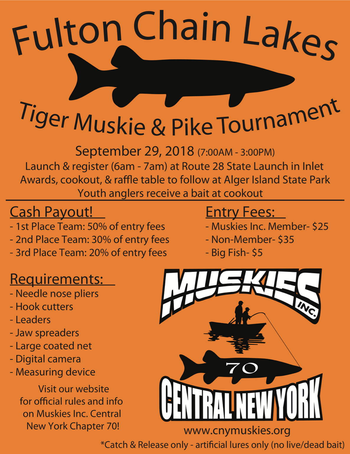 Why do you exclude Fifth Lake? And why C+R only, the pike should not be in that lake to start with, removing them would do all the Trout and Salmon anglers a favor?
 -
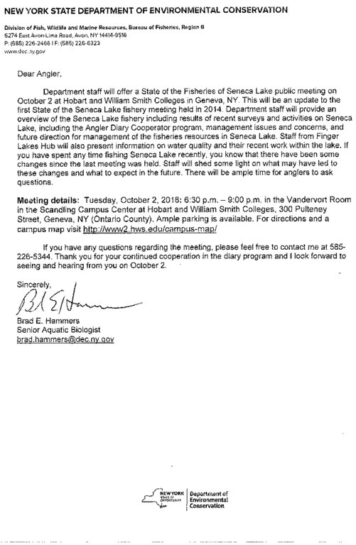
Status of Seneca Lake DEC Meeting 10-2-18
Lucky13 replied to Sk8man's topic in Finger Lakes Discussion
DEC Delivers Press Release - Information to keep you connected and informed from the NYS Department of Environmental Conservation Share or view as a web page || Update preferences or unsubscribe DEC Announces State of the Fisheries of Seneca Lake Meeting Public Meeting October 2 As part of Governor Andrew M. Cuomo's NY Open for Fishing and Hunting Initiative, the New York State Department of Environmental Conservation (DEC) announced today that DEC's Region 8 Fisheries Management Unit will present recent sampling results and summarize management efforts on Seneca Lake at a public meeting on October 2. "This public forum on the state of Seneca Lake fisheries provides an opportunity for DEC fisheries scientists to share their knowledge about fishery resources with the public," DEC Region 8 Director Paul D'Amato said. "New York provides excellent opportunities for interested anglers to interact with the managers studying these fisheries. Our staff is committed to sound management of the Finger Lakes' fisheries and strives to maintain high-quality angling opportunities and associated economic benefits." The Finger Lakes and their tributaries support thriving populations of fish, including a variety of trout and salmon, bass, walleye, yellow perch, panfish, and esocids. Seneca Lake, the largest of the Finger Lakes, comprises more than 43,300 acres. A 2007 statewide angler survey estimated 178,340 angler days were spent on Seneca Lake making it the 8th most fished water in the State. The estimated value of these fisheries exceeded $5.9 million to the local economy. The meeting, hosted by Hobart and William Smith Colleges, will be held on Tuesday, October 2, 2018, from 6:30 - 9:00 p.m. in the Vandervort Room, Scandling Campus Center at Hobart and William Smith Colleges, 300 Pulteney Street, Geneva, NY (Ontario County). Ample parking is available. For directions and a campus map, visit the Hobart and William Smith Colleges website (link leaves DEC webpage). DEC biologists will provide updates on the status of trout and salmon fisheries, warmwater fish, fishing regulations, water quality and DEC's Angler Diary Program. There will be time allotted at the end of the scheduled program for the audience to interact with the presenters. http://www.dec.ny.gov/press/77537.html -
Front of Genny 9/15
Lucky13 replied to BreakingBass's topic in New York Fishing Reports - Lake Ontario (South Shore)
 The Temperature in the River dropped into the low sixties last week (as reported downtown at Ford Street). They could have headed up on that, but it was also very muddy. As of today it is back up into the low seventies.
 -
Fat Guy in a Little Boat
Lucky13 replied to Low Baller's topic in New York Fishing Reports - Lake Ontario (South Shore)
 Are the boats that tight right at the mouth? That would say the circus will get going upstream any day now.
 -
Fat Guy in a Little Boat
Lucky13 replied to Low Baller's topic in New York Fishing Reports - Lake Ontario (South Shore)
Florence is not supposed to be a factor in our weather until Tuesday. Or not!! -
He originally asked a "simple question" about kayak trolling in the Salmon River estuary, and apparently could not handle the level of detail graciously provided by those of us who responded. We should have just told him to stay under the bridge!
-
It takes one to know one!
-
Don't post to begin with asking questions and partially reading the answers! The guy who posted about one rod two rods, and Lake Huron sounded Canadian. You sound like a EDITED. You are welcome, and...and EDITED! Topic Closed & Locked
-
The above sounds like it is Canadian. I think the OP is asking about the Salmon River in New York. He was asking about the estuary, which comes under tributary regulations, in his other post. The estuary is a part of the river regulations and begins at the lake as follows, "From the upstream most navigation buoy located between the breakwalls at the mouth of the river upstream to the County Rt. 52 bridge in Altmar." That is all of the river except the fly only sections. http://www.eregulations.com/newyork/fishing/special-regulations-great-lakes-tributaries/ Until October 15, one hook point, which also means one rod. After October 15, floating lures can have multiple points, but you will not likely be in the estuary then. If you are out in the lake in NYS, you can use three rods, but that I want to see with a kayak, it is hard enough alone in a small boat. IF you do go out in the big pond, remember that it changes VERY rapidly, and is VERY unforgiving.
-
You will finds that the difficulty in this area is deciding where to go and what to fish for, as there are so many places that hold fish and so many varieties of fish. Even if it is winter and pretty much a steelhead game, it can be problematic to decide where to go try for them, and a summer charter can also present issues of what to go after. Spring and Fall, forget about it!!!! Thanks for the compliment to the Rachacha area, we usually get told we are smug!
-
9/1 Genny
Lucky13 replied to LongLine's topic in New York Fishing Reports - Lake Ontario (South Shore)
 "My intuition tells me that if on the 4th, 9th, 6th & 14th trawls of the year, they had shifted their longitude to the right by a few degrees instead of the left, the years results might have been different." Random distribution would say that there is an equal chance of hitting the big pod or the empty one. If the pooled mean for a year is going down in relation to prior year's means, it is an indication that the overall population has declined. If there is that much more bait out there, in a random sampling you should hit more of those big pods. The trawl methods were vetted by Sea Grant, and were indicated to be representative and provide a fair measure of the bait. If they switched to a random trawl method, there would be comparability issues, and, of course, everyone would say they ran the wrong random trawl transects, unless they liked the data they saw. Back to Andy Todd, if you want to continually reject and second guess the data, maybe it is time to save some money, just dump in a big bunch of fish, and let the chips fall where they may.
