


LongLine
-
Posts
4,333 -
Joined
-
Last visited
Content Type
Profiles
Forums
Events
Gallery
Store
Everything posted by LongLine
-
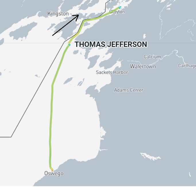 Topped off the tank, picked up the "kids" and headed back home to Virginia after a fun summer. Goodbye Jeff.
 -
 California and Oregon ceased commercial pens many years ago. Washington only allows it in a single Puget Sound estuary but has terminated that company's permit. (Estuary raising beneficial to avoiding lice due to lower salinity and flow.) Issues were more from Atlantic Salmon than Kings. Biomass, when thought of as "tonnage" of Alewife is not an issue. But (referring to the 2025 preyfish assessment) The number of age-1 has exploded whereas the number of older alewives has greatly decreased for a few years now. Additionally, the "condition" of the Alewife population has also been decreasing for a few years. Lower "condition" implies less fat & fatty acid from food supply (Fleas) and less thiaminase. Hence predators won't lose as much B1 by eating more age 1 alewife. (The higher the B1, the greater probability of reproductive success for Kings.) __________________ Atrazine is not banned in NYS (except Nassau & Suffolk counties) but is a "restricted use" chemical meaning that it's not available to general public and requires special certification to use it.
 -
"You are what you eat" Thiamine is the fancy name for B1 vitamin. It doe not "biosynthesize." I.E. A food containing B1 has to be eaten and then the "eater" has to absorb it. (Not like vitamin D in humans with sunlight or photosynthesis) Thiaminase is the fancy name for enzymes that break down B1 vitamin, interfere with absorption of B1 and associated with some fatty acids. Both come from what fish eat. Low B1 level is called "Thiamine Deficiency." High B1 yields better survival/reproduction success. DEC treats eggs with a B1 bath in hopes that the eggs will absorb it with no thiaminase present. There is no natural immunity from thiaminase, rather if a fish has high B1, then the enzyme will still decrease its B1 level but not to a level where it's detrimental to its health. Study has shown variation in alewife thiaminase activity in Lake Michigan (https://pubs.usgs.gov/publication/70037235) for unknown reason but diet suggested as a main driver. As to wild King survival, two thoughts/questions come to my mind: #1: Alewives appear to be eating more sea fleas. Has Alewife Thiaminase content decreased because of this? Hence spawning Kings and their offspring have greater B1 content to start life with? (Perhaps for a couple/few years.) #2: The Alewife biomass has increased in last few years predominately due to high numbers of age 1 & 2 fish. Human health advisories say: "don't eat fish over a certain size due to increased contamination levels." Does this imply smaller alewife do not contain as high a level of thiaminase as larger ones? Moreover, if the Kings are forced to eat smaller Alewife (as that's what's available) is their thiaminase content less and B1 level of Kings less diminished? Hence their eggs have greater B1 concentration thus greater survival?
-
Jefferson still in port. HOYI showing up next to Kaho. EPA Lake Guardian in west-central Lake Erie:
-
Guess you haven't heard about the CDNs putting restrictions on commercial trawling for herring (alewives) in order to increase the food source; or demolishing dams to open up spawning grounds; or river habitat restoration projects; or that King Salmon season was closed for a couple years and is highly restricted or Anchovy Thiaminase studies?
-
Kings in the Pacific NW have also undergone size change, even more drastic than ours.
-
few stops on the way and back to port:
-
WTF?...Maybe double checking waypoints?
-
Frustration would skyrocket with more empty coolers. (lower catch rate) Higher frustration causes less effort and return trips. Less effort means less fishermen and tells "money people" that expenditures can be better spent elsewhere. Anyone express concerns/inquires/questions to Sea Grant-Cornell Univ? Or ESF-Syracuse? Or Tunison? Or SUNY Brockport/Oswego or faculties at other institutions? Or NOAA Fisheries? Or USGS? Or USF&W?
-
Great recipe. Haven't heard from you in quite a while...Have you figured out who's smarter than a 5th grader yet?
- 1 reply
-
- 1
-

-
"Method to the madness" or "Madness to the method" ?
-
Wonder how much fuel this guy has used????
-
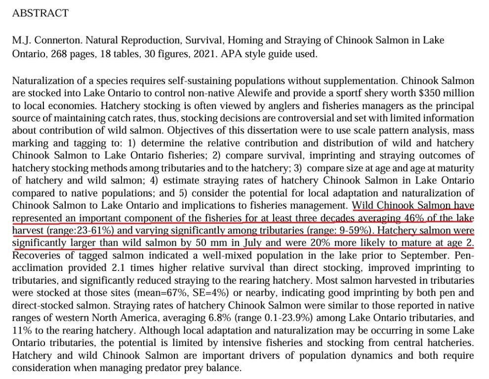
I agree the issue is a matter of genetics and evolution. Overfishing is plausible if fishers used trawling nets, but with rod/reel and a 3 bag limit...no way! Especially with the decline in boat trips over the last 15 years. Given a catch rate of 3.5 per trip and the number of fish out there, overfishing today is a very minimal probability. Selective harvesting is interesting...if anyone has a fish finder that can distinguish between a 25 Lb'r and a 30 Lb'r please send me make/model so I can go buy one! () We go deeper when encountering shakers, but we don't go to the 20 line for 25 Lb'rs and then 20.5 line for 30 Lb'rs. If any charter has a hard & fast rule that his clients only keep fish over 25 Lbs, I'll be the first to write a great yelp review for him. A 25 Lb'r will likely hit a Magnum or meat rig just as a 30 Lb'r will. Any LOC guy that catches a 30 Lb'r and doesn't immediately race in for the weigh station is a dam fool! Likewise, any "lip-ripper" that claims he can distinguish between a moving 25 Lb'r and a 30 Lb'r in a stream, given refraction of light, turbidity and distance to fish, is probably off his meds. Yes, the Kings have been trending smaller. LOC records and Lake Ontario Annual reports have documented it. Here's all the top LOC finishers for a number of years. (winner plus top 20) Big fish generally produce big offspring. One item briefly mentioned so far is Nat Repro Kings which comprise a substantial proportion of the fish out there. (currently over 60% and has been documented since the 90's) For those that don't remember the adipose clipping trailer study by a credible LO biologist: ("more like to mature at age-2") Naturals are also slightly smaller at age-3. Here's the full report: https://experts.esf.edu/esploro/outputs/doctoral/Natural-Reproduction-Survival-Homing-and-Straying/99885320304826 Both Naturals and Stocked Kings spawn in the SR. With microscopic/laboratory analysis, one can tell the difference between the two (see full report) but I'm fairly certain the "egg takers" don't differentiate. So, the question is what will the resultant hybrid offspring be if a stocked female eggs are fertilized with a Naturals milt? Or what if both are Naturals? What if what we're seeing every year is a greater number of Naturals weighed in or more and more 6-7-8th generation hybrids? I think it'd be a great study for some grad student to look at the LOC place finishers to see if Natural or stocked.
-
And now back to east end. Must be something interesting there.
-
Jefferson went back to mapping the East Central region:
-
How many times is Jefferson going to map the same area?
-
2903 went east then back to play around in the harbor: Seth Green made the trip to the Genny:
-
HOYI off the trailer (and off the wall?) 2903 off his meds?
-
Great day for a boat ride with a couple stops along the way: Jefferson docked in Oswego.
-
What is so interesting at arrow #3?
-
Working through the weekend then back up to the harbor:
-
He was. Jeff' dropped the kids off early to work the nearshore at Oswego then headed back up there:
-
Going to check put the harbor?:
-
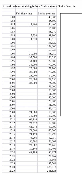 SK8 - Years ago at a State of The Lake meeting, it was theorized that they might, but without any evidence. Look at that video I posted in other thread (GLFC Presentation); at the end of it. CDNs are doing a study with acoustically tagged AS to see if they return to a couple of stocking locations. We'll have to wait a couple years, but it should provide some data as to where they go.
 -
Jefferson repeated some of path from Tuesday, then came in to drop off "kids" to work closer to Oswego. Currently "combat" trolling off Pulaski and east end. KAHO currently in Oswego. Was joined briefly by R/V HOYI, (25 ft'r - specializes in Bloaters & Cisco) but has either turned off AIS or gone back on trailer. EPA Lake Guardian left Milwaukee and currently parked at Sault St. Marie.