

Lucky13
-
Posts
1,234 -
Joined
-
Last visited
Content Type
Profiles
Forums
Events
Gallery
Store
Everything posted by Lucky13
-
If there is a place to use clamps on the rail somewhere, Downeast makes great portable rod holders, got mine from Cabella's. http://www.cabelas.com/product/fishing/fishing-tools/fishing-rod-holders|/pc/104793480/c/104720580/sc/104538780/down-east-single-clamp-rod-holder/699614.uts They have gotten little pricier since I bought mine!
-
Lake Ontario Fisheries History Lesson
Lucky13 replied to RUNNIN REBEL's topic in Open Lake Discussion
 I'll have to admit to a great deal of surprise reading about the use of copper and leadcore nowadays, I thought it was still mainly riggers for LO. I've been using the wire lines for a long time up in the 'daks, but riggers are a lot less useful in smaller lakes with very rough bottom structures, and you can adjust rapidly pulling wire. There is almost nothing like hanging a downrigger ball on a granite ledge in 80 feet of water!
 -
I fish the western 'daks in August. We find the landlocks right on top on calm mornings, generally using Lake Clear wabblers with a 30 inch leader and a two hook gang and minnow. You want to be on the water with the lights on the boat, well before legal sunrise, and we quit as soon as the skiers start, or the fog lifts, unless the fish are still showing here and there.
-
Lake Ontario Fisheries History Lesson
Lucky13 replied to RUNNIN REBEL's topic in Open Lake Discussion
Let's just please remember that that 7 lbs of Coho growth in a few months was in the presence of an uncontrolled, massive bait base. It is a very different situation out in LO right now than the upper GL in 1966. Even with the preliminary bait data indicating a better alewife year class last year, the size structure still says there is a 2 year "hole" in the population that will really start impacting adult kings next year and afterward for a while, so the ice on which we are skating is still a bit on the thin side. But please post the rest of it, Jerry, as this whole discussion will be coming up again very shortly, only about two months until egg take time, so the target numbers discussion is looming. -
Moosehead Lake, ME
Lucky13 replied to Fishin' Finn's topic in Questions About Trout & Salmon Trolling?
 Sutton 44's also work great anywhere that Mooselooks are used.
 -
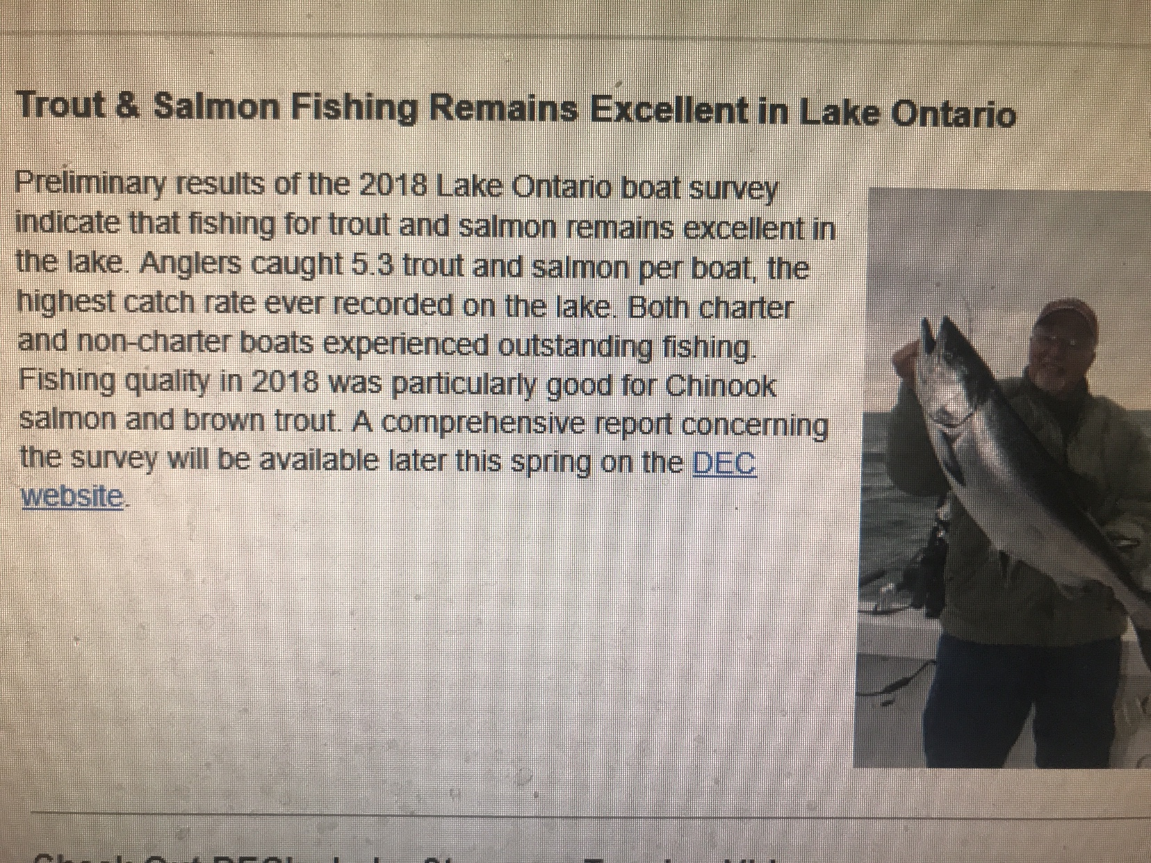
 Here is what DEC reported in 2013. My bold added. http://www.dec.ny.gov/outdoor/90304.html Skaneateles Lake There are no alewives or rainbow smelt in Skaneateles Lake. The main forage base is yellow perch (young of year). Other important prey species are emerald shiner, sculpin, freshwater shrimp and Ephemeroptera (mayflies). Ephemerptera create a unique fishery in early-summer, as they are abundant with most species of fish feeding on them. Lake trout fishery is maintained entirely by natural reproduction (no stocking). The 2012 Skaneateles Lake stocking was 5,000 Finger Lakes Strain Wild (FLW) and 15,000 Finger Lakes Hybrid (FLW X domestic) rainbow trout, and 9000 Atlantic salmon stocked. Cisco numbers appear to be down in Skaneateles Lake. During the 1989 Standard Gang Netting 152 cisco were captured, only eight in 2008, and zero in 2012. VHS (Viral Hemorrhagic Septicemia) was found in the lake in 2006 and may be a possible cause. 2012 angler diary cooperator legal fish/trip was 1.32 lake trout, 0.34 rainbow trout, 0.01 Atlantic salmon. Lengths of harvested salmonids by angler diary cooperators have increased in last few years, as have smallmouth bass lengths. Owasco Lake The 2012 Owasco Lake stocking was 25,000 rainbow trout, 10,000 brown trout and 10,500 lake trout. Lake trout stocking has seen long term reductions. The significant walleye stockings occurred from 1996 to 2006. The Owasco Lake Anglers Association stocked from 1996-2001 and DEC from 2002-2006. Angler diary cooperator trips dropped below 250 in 2008 and has remained low since. Good mix of lake trout, rainbow trout and brown trout (including some real trophies) throughout the 1990s. Lake trout angler catch rates increased through early 2000s despite the population declining since the mid to late 1990s. The sharp declines in the brown trout and rainbow trout fisheries in the early 2000s coincided with the emergence of walleye in the fishery. Walleye and lake trout are both long lived and prey on stocked trout (and themselves!) and the effects of stocking changes take time. We maintained viable fisheries for brown trout and rainbow trout during and following peak lake trout abundance. The timing of the emergence of walleye in the fishery make them prime suspects contributing to the disappearance of the fisheries for brown trout and rainbow trout. So far we have taken steps in an attempt to recover the fisheries for brown trout and rainbow trout. The loss of these fisheries was not discussed as an acceptable consequence of the walleye program. Have not stocked walleye since 2006. Reduced lake trout stocking over the long term. Continued stocking brown trout and rainbow trout. We need to determine if this is the desirable direction (preferred by most) to take the fishery. Some anglers prefer walleye over trout, while other anglers prefer trout over walleye. We will not continue to manage the lake for both. We are doing a survey in 2013 to assess angler desires. "Bucket Biologists" stocking their idea of a desirable fish into lakes where they are not found have ruined a huge number of fisheries in New York State, and should be discouraged whenever encountered.
 -
Gill nets are only legal in the Finger Lakes, and not all of them. The only legal net in Lake Ontario is a seine, maximum of 36 feet square, or a minnow trap, and I don't know that alewifes would go into a minnow trap.
-
A good spot from shore on Tupper is at the mouth of the Bog River, near the south end of the lake. Nice picnic spot, too, and natural rock "waterslides" that are popular in the summer.
-
This is not the fishing reports section, it is open lake discussion, and how to get to a launch seems to be a good fit there, IMHO!
-
Sawbelly = alewife
-
You all definitely need to review the baitfish regulations. I would say a call to NYSDEC would be warranted before bringing Florida baitfish into NYS Waters, as the language dealing with Marine species is as clear as the Genesee River in March! Alewife is limited to the following lakes: Alewife: Canandaigua Lake; Canadice Lake; Cannonsville Reservoir; Cayuga Lake; Cayuta Lake; Conesus Lake; Hemlock Lake; Waneta Lake; Hudson River downstream from Lock C-4 and its associated dam in Stillwater to the Battery at the southern tip of Manhattan Island; Keuka Lake; Otsego Lake; Otisco Lake; Owasco Lake; Lake Ontario; Lake Erie; Lamoka Lake; Pepacton Reservoir; Seneca Lake; St. Lawrence River; Niagara River; Mohawk River, and all waters in Dutchess, Orange, Putnam, Rockland, Sullivan, Ulster and Westchester counties. The regulations are challenging, but where I fish in the 'daks, we get checked quite frequently, for species, and the dated receipt.
-
From the NYSDEC Website on the Guide's program: Individuals engaging in the business of guiding on all lands and waters of the state shall possess a license issued by the department. There are, however, some exceptions. They include persons operating or assisting upon a public vessel for hire (passenger carrying vessels), licensed by the United States Coast Guard or New York State while on the following waters: The Atlantic Ocean All other marine, coastal and tidal waters including: The Hudson River up to the Troy Barrier Dam The St. Lawrence River and the navigable portion of its tributaries The Great Lakes and the navigable portion of their tributaries Lake Champlain and the navigable portion of its tributaries Cayuga Lake and Seneca Lake and the navigable portion of their tributaries
-
Was there really any reason to doubt that those were his true intentions?
-
Coast Guard license holders do not have to get a NYS Guide license for fishing.
-
If you look at the plots they were on the same track as in Dec 2015, the lake starts going up in December every year on that plot. Dec long term average rainfall is 2.63", we got 2.91", January is 2.41, we got 2.56, Feb is 1.95, we got 2.33. The starting stage in Mid December and stage through mid march are nearly identical to 2015. But in March, long term average rainfall is 2.5", we got 4.67", April is 2.73, we got 4.95, and May is 2.87, we got 5.29. Mid march is when they would have been letting the water go, but they had no ice to allow the higher discharges, and these are extraordinary rainfalls, and they had even higher rainfall over the area surrounding Montreal. The averages and monthly totals are what was recorded on Weather underground for Rochester.
-
http://w3.lre.usace.army.mil/hh/ForecastData/BulletinGraphics/MBOGLWL-ontario.pdf Lake Ontario levels were slightly below the long term average from early June 2016 until mid December, when we started to get the precipitation. As an example of water coming into the system, the Genesee River was above 2000 cfs for most of the winter, basically unfishable for the whole season with the exception of about 5 days. Maybe these guys have a functioning crystal ball, if they knew what the weather would bring that far in advance. http://w3.lre.usace.army.mil/hh/GreatLakesPrecipitation/GLP-ThisMonth.pdf http://w3.lre.usace.army.mil/hh/GreatLakesPrecipitation/GLP-LastMonth.pdf So far in May, LO has received nearly twice as much rain as the historic average, and had 155% of average in April. https://www.thestar.com/news/gta/2017/05/25/toronto-rainfall-breaks-record-set-in-1953.html
-
Where would you have put all that water? Please also remember that while LO was 33" over normal average, Montreal was 55" over average. Record rainfall does not confuse the issue, it clarifies it unless you absolutely have to place blame somewhere other than nature. When you build a house on a floodplain, occasionally you have a floodplain on your house, but it usually requires an extraordinary amount of water, which is what we got in April and May. It is also high in Erie, which is not controlled, and all the inland lakes that feed LO are high, no IJC or Board of Control there, although agencies like the Black River Regulatory District are definitely holding water anywhere that they have control, like in the Fulton Chain of Lakes.
-
The board of control people, many of whom opposed 2014, have indicated that they were on track with 2016 levels into January, but they were unable to discharge at the normal winter rates in the St Lawrence due to lack of ice cover. Once the STL gets locked up, they can let it rip under the ice, no shipping problems as there is no shipping in a frozen channel, and no shore impacts because the ice constrains the level of the water, and the velocity of the flow can increase under the ice just like in a pipe. Without the ice cover, discharge had to be throttled down to prevent shore erosion along the STL. And then the rains, double the normal amount of water. In a totally uncontrolled system, no dam, no regulation, this kind of high water would occur once in a while, also the kind of low water that makes Braddock totally unnavigable. AS to the Braddock project being related to 2014, it may have been harder to convince Region 5 EPA to put up the money if it was assured that 2014 would be enacted, as much of what was built in Braddock was designed to mimic the effects of more level variability without the variability involved in 2014.
-
http://www.dec.ny.gov/docs/fish_marine_pdf/pfrcohoctriv.pdf http://www.dec.ny.gov/docs/fish_marine_pdf/pfrmillckr8.pdf Also check the State forest map against the stocking lists. NYSDEC does not stock streams with no access, but may not have formal easements, and where stocked streams run through State forests or FWMA's may be your easiest access.
-
You'll likely never know without trying. But, again, make sure you knock on some doors, there is not a lot of public land down there, or talk to the ranger in charge for info if you are looking at NYS Forest lands.
-
New temporary "no-wake" within 500' of shoreline.
Lucky13 replied to John E Powell's topic in Open Lake Discussion
 Same amount comes out as goes in! Does not matter whether it goes into the plant or over the falls, it all ends up in the Big O!
 -
Burnham Point closed, the launch north of town is listed as open. http://www.dec.ny.gov/outdoor/23890.html
-
Cape Vincent DEC Closes Public Facilities at the Cape Vincent Fisheries Station High Water Levels Causing Flooding Due to high water levels on Lake Ontario and the St. Lawrence River, the New York State Department of Environmental Conservation (DEC) has closed the aquarium, fishing access site, and overnight dockage at the Cape Vincent Fisheries Station until further notice. The picnic area will remain open. However, visitors are advised to use caution and remain a safe distance away from docking areas.
-
2014 yearling population was very low and 2015 yearling was nearly non-existent in the trawls. These would be the preferred size for salmonid predators now,( Literature says 2+ and older are the preferred food size for salmonids) but they are not there in any significant numbers. It would be logical then that salmonids, especially smaller ones like Brown trout, would turn to the yearlings from the 2016 hatch, which would be small now (2-3"). The 2016 hatch was better in the trawls, not record breaking but healthier. The literature also says they are a fragile fish, so conditions out on the lake this year with prolonged turbidity, high water, and fluctuating temperatures cold be inducing some mortality. The lake was rough enough to exacerbate the flooding on Saturday, maybe that knocked some of the little ones around. Or if you are seeing large (6-8") ones on top, that could just be natural mortality, they don't live forever, maximum recorded age is 9 years.
-
There is also a risk that if you killed all the mussels at once, this would start a massive outbreak of Type E. Botulism, with repercussions all through the food chain of the lake. And there is also the issue of cost.