

LongLine
-
Posts
4,171 -
Joined
-
Last visited
Content Type
Profiles
Forums
Events
Gallery
Store
Everything posted by LongLine
-
 So where do you set your drag for "no-fish" break-offs?
 -
 It's great that wild Browns can be found in the creek. Browns & Rainbows are basically homebodies compared to all the salmon. Browns can thrive in almost any water which is why they were introduced to the US years ago. Murky, low oxygen, some pollution, somewhat brackish, etc. Not saying the creek is that way, but the Bay is. The only time Salmon don't care about water conditions is at spawning time. I don't doubt that salmon will make the trek upstream as some Kings have even been seen in road culverts out Hilton way. I only question whether Atlantic's will make the trek out to the lake in appreciable numbers. At all the historical LO stocking sites, freshly stocked fish have a relatively unobstructed path to the wide-open lake. I-Bay is a big obstruction. Salmon need oxygen, more so than other species. I-Bay is a long fairly narrow bay, oriented North-South. Prevailing west winds don't stir it up like other embayments. Its topography, with that deep spot, sharp drop-off and the northern flats greatly increases its retention time. Years ago, they treated the water to try to get pollution to settle to the bottom. They also ran a "bubbler" south of the bridge to put oxygen into the waters as it was considered "dead water" below 15 ft from the surface. I.E. it's prone to stagnation. It's a great habitat for sheepshead (drums) of which many get "huge." In addition to the physical, as already mentioned, there are many predators. Along with the Bass & Pike, DEC has been stocking Walleyes in there for quite a while. (Unknown how they're doing as Walleye fishermen are known for being tight-lip'd) As the initial article is about Atlantic restoration in Lake Ontario, the more I think about it (and as you said there may be a shortfall in stocking) they should stick with the original 4 sites. IMO, DEC should evaluate survival in the lake first, then evaluate Nat. Repro at those sites second, and then look at other stocking sites.
 -
"New" to you doesn't mean its "fresh" line. Mono, flouro and Co-poly all deteriorate over time, dryness & exposure to sunlight. I've bought line that was worthless right out of the packaging. Retailer may have had it in stock from last season. I always test line before using it by placing a strand between my thumb and 1st finger. Then, squeezing it, pull about 18 inches through. If there's any white powdery residue on my finger....it's worthless. That's "plasticizer" coming out of it and the line will be brittle and have no scratch resistance..
-
Not for or against it but have many questions: 1. yes temp tolerance 76-77F or so but what about the north flats of I-bay. Will they cross that large section that is only 5-6 ft deep? It gets pretty warm there, before the drop-off. 2. yes I-bay has temp relief in the deep area but does it have the oxygen content below 20 ft? That deep section is not very long proportionally to the lenght of the bay. 3. Won't bay boaters have an issue with "wood is good"? Recreational or fishing. I don't know any that want more debris in the water.
-
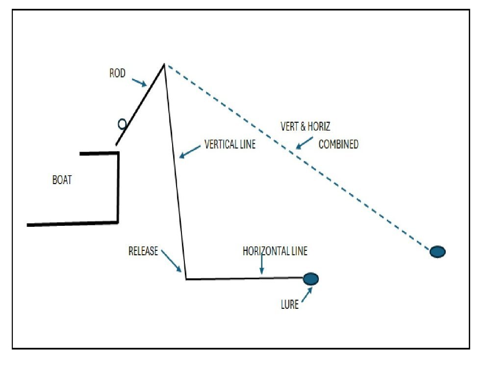
The fish generates the most shock on its initial hit. When stream fishing that shock must be absorbed by the line and near instantly the rod. Line stretch plays an important part of absorbing it. When trolling with a rigger (or planner/dipsey) there are 2 components to the line that have to go tight which help absorb it before the rod takes over. For a rigger there is a vertical and a horizontal component. There is some absorption as the vertical becomes part of the horizontal. (Resistance of the water on the line) You'd have the same situation from a boat, as in a stream. if your ran a clean line less than 25-30 ft off the back of the boat, especially in the cold. Chances of a break-of are also greater with a short rod. Most rigger rods are 6 1/2 - 8 ft long.
-
Davy - Any word back from Mike as to whether they were SEB-TT strain? (WR supplied both SEB and SEB-TT) Also did any of the Atlantics that you saw have lamprey marks on them? It's my understanding that Atlantics were also going to come from Eisenhower National Hatery this year. (also in Vermont) There was a fear that stocking Irond' Creek would have a very low probability of sucess due to them having to traverse the bay which was thought to have too many predators. I.E. Bass, Walleye, Pike and Comorrants.
-
That was only one delivery. Looking at the 2023 LO annual report, there were 4 stocking sites with each getting about 50,000 yrlgs. Those each 50,000 came from 2 different hatcheries. The Wright River in Vermont (WR) and Adirondack in NY. (AD) Within those 2 hatcheries (WR & AD), there were 3 strains delivered over a 6 week period. WR had a hatchery stock from Little Clear in Maine (Sebago - designated SEB) and USF&W developed a new "low tolerant Thiamine" strain (SEB-TT) there. AD yrlgs were from their hatchery stock of SEB. (Designated NSB). NSB was not marked. The others were PBT (parentage based genetic tagged- i.e DNA recorded) Delivery quantities varied between 11,000 and 20,000 at a time. Each site received all 3 strains, at different times each. Overall deliveries to all four sites were NSB - 53,000; SEB - 87,000; SEB-TT - 53,000. Sandy had 3 deliveries. Given only 16K in that delivery then keep your eyes open as there will be more deliveries. And hopefully the SEB-TT strain.
-
Yes. At the south end. Use one of the middle ramps.
-
 Thanx for update.
 -
I-bay is a fairly shallow launch. That big of a boat may be very problematic there. The genny is a deep water launch & I've seen larger boats launch there without a problem.
-
 Technically the Capt & crew are fishing as the purpose of a charter is to assist a client to catch fish. DEC regs define fishing as: "Fishing means the taking, killing, netting, capturing, or withdrawal of fish by any means. This includes every attempt to take fish, plus assisting another person in taking or attempting to take fish." Interesting debate. Legality and Sportsman morality can be different things. IMO, capt is responsible for what happens on his boat and as long as it's legal, sets the rules.
 -
I agree that any properly resuscitated & released salmon (that hasn't been foul hooked or mangled up) has a very high chance of survival. Keyword being resuscitated. If released like Bass fishermen do on TV, they won't survive, regardless of whether they're in the slot or not. Having a slot doesn't prevent them being landed. In a small boat it's fairly easy to resuscitate a salmon. It's also easy to release them before they're brought in the boat. It's precarious to do either in most lake boats that I've seen as the freeboard is too high or there's too much gear along the sides to reach the water line. I suppose one could resuscitate with a net but I don't know how one would keep the fish upright and headfirst.
-
What is the advantage to a slot limit on Salmon?
-
 Ice cover prevents evaporation; hence the lake level will stay higher longer. (which for both Erie & Ontario is very low right now) I don't know how it affects the growing season but I'm sure some were complaining about their lake effect snow fall this year, especially on the east end. As to why the CDN plant not as affected, I can only guess it has to do with the historical clockwise flow of water in Erie (unlike Ontario) that generally drives it towards the US. If the ice chunks are strong enough to "scour" the spawning areas, then they're strong enough to damage docks. If one is fishing/cruising and hits a submerged/floating beam and damages their prop or worse...I guess they just shouldn't have been fishing/cruising there. (Don't we have enough "crap" to avoid out there?)
 -
And how much damage has been avoided since 1964 (when boom first utilized) ? How many more docks, boathouses, launch sites have been built since '64? Modis imagery shows ice formation size has been reduced by approx 70% from 3/25/25 to 3/27/25, so how much of growing season has been lost. especially with the up & down "springs" we get? If there's ice coming down the river, is it from erie or from welland and east of the falls? Power companies don't pay anything. They pass all costs along to their customers. I wonder how much they'd add as a surcharge to his utility bill for repairing/replacing the main intakes to the power station every year.
-
If the ice "chunks" are big enough to scour the spawning beds then they'll cause a lot of damage to river front property such as docks, boat houses etc. There's plenty of other things in the rivers to avoid running into. Who'll be the 1st fisherman to damage his rig hitting ice?
-
NY has a population of 19.6 million and NYSDEC employs just shy of 3,000. This equates to 1.5 DEC employees per 10,000 residents. Pennsylvania has population of 12.8 million and DEP employs 2,500 which equates to 2.0 DEP employees per 10,000 residents. Ohio has population of 11.7 million and ODNR employs 3,300 which equates to 2.8 employees per 10,000 residents. NYSDEC would need 3,920 employees to reach PA's ratio of 2 per 10,000 residents. They'd need 5,488 to reach ODNR ratio of 2.8. ODNR operates 6 hatcheries and stocks approx. 320 locations. Pa Fish & Boat Commission (DEP) operates 12 hatcheries and stocks 823 locations. NYSDEC operates 12 hatcheries plus the Lake Ontario Unit. They stock over 1,200 locations. Looks to me that NYSDEC does a lot more with less than these other states and is greatly understaffed. Although some would, I would not rely on an apprentice plumber to fix an electrical problem in my house.
-
Haven't kept a fish in over 30 yrs. I don't believe high mortality rate with salmon. Just keep them head-first into the current for a minute then push them headfirst towards the bottom. Stlhd & LTs more "delicate."
-
Siwash hooks on spoons ??
LongLine replied to Mike M's topic in Questions About Trout & Salmon Trolling?
Switched the majority of my trebles to siwash a long time ago. I use 2/0 & 3/0 on NK28 sized spoons. Put the point facing the cup of the spoon. -
Boating Frequently Asked Questions - NYS Parks, Recreation & Historic Preservation Persons over 18 and renting a boat don't need it. Persons under 18 renting one do need it. As to enforcement: Any law enforcement in your boating area can enforce it. At the Genny this includes the RPD, MCSD, State Police, NYSDEC, USCG & Border Patrol.
-
Thanx Pete. Glad the offer was made to those guys to be rehired. We're keeping fingers crossed that all works out well.
-
Latest anti-outdoor decisions from Washington
LongLine replied to Gill-T's topic in Open Lake Discussion
There are a considerable number of army/air force bases that have beem closed and not being used at all. If affordable housing is the real driver, why not develop them? They already have roads, utilities, are near towns, etc. Why dig up pristine lands in the middle of nowhere when this land isn't being used at all? -
Thanx Pete. I appreciate the info.
-
Latest anti-outdoor decisions from Washington
LongLine replied to Gill-T's topic in Open Lake Discussion
Well, it only takes about 170 acres for a golf course. Another 70 or so for an airstrrip. Another 50 for a hotel..... Wonder who'd buy that? -
ttt They're at it again. It looks awful real! DO NOT CLICK on the notification to see the reply.

